Point Clear - H L Sonny Callahan
Airport details
| Country | United States of America |
| State | Alabama |
| Region | K7 |
| Airspace | Jacksonville Ctr |
| Municipality | Fairhope |
| Elevation | 95ft (29m) |
| Timezone | GMT -6 |
| Coordinates | 30.46050, -87.87703 |
| Magnetic var | |
| Type | land |
| Available since | X-Plane v10.40 |
| ICAO code | KCQF |
| IATA code | n/a |
| FAA code | n/a |
Communication
| H L Sonny Callahan CTAF/UNICOM | 123.000 |
| H L Sonny Callahan MOBILE Approach/Departure | 118.500 |
Nearby Points of Interest:
Street House
-Twin Beach AME Church
-Lebanon Chapel AME Church
-United States Post Office
-Tolstoy Park
-Sunnyside Hotel
-Governor's Club
-St. Paul's Episcopal Church
-Montrose Historic District
-Methodist Episcopal Church, South (Daphne, Alabama)
-Foley Downtown Historic District
-St. Patrick's Catholic Church
-Martin Lindsey House
-Miller-O'Donnell House
-USS Tecumseh (1863)
-U. J. Cleveland House
-Brisk & Jacobson Store
-Pincus Building
-Bishop Portier House
-Oakleigh Historic Complex
-Barton Academy
-Martin Horst House
-Historic Roman Catholic Properties in Mobile MPS
-Raphael Semmes House
-Cavallero House
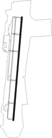
Runway info
| Runway 1 / 19 | ||
| length | 2019m (6624ft) | |
| bearing | 11° / 191° | |
| width | 30m (100ft) | |
| surface | asphalt | |
Nearby beacons
| code | identifier | dist | bearing | frequency |
|---|---|---|---|---|
| BFM | BROOKLEY (MOBILE) VORTAC | 12.9 | 310° | 112.80 |
| NUN | SAUFLEY (PENSACOLA) VOR | 28 | 89° | 108.80 |
| MOB | WISLE (MOBILE) NDB | 28.4 | 305° | 248 |
| SJI | SEMMES (MOBILE) VORTAC | 29.5 | 299° | 115.30 |
| NPA | PENSACOLA TACAN | 29.6 | 100° | 117.20 |
| PKZ | PICKENS (PENSACOLA) NDB | 36.1 | 92° | 326 |
| NSE | WHITING (MILTON) TACAN | 47.1 | 73° | 112.30 |
| NGS | SANTA ROSA (MILTON) TACAN | 49.4 | 81° | 133.60 |
| GCV | GREENE CO. (LEAKESVILLE) VORTAC | 49.5 | 316° | 115.70 |
| MVC | MONROEVILLE VORTAC | 65.7 | 28° | 116.80 |
Instrument approach procedures
| runway | airway (heading) | route (dist, bearing) |
|---|---|---|
| RW01 | BFM (130°) | BFM HITGA (19mi, 188°) 2000ft WITOR (5mi, 105°) 2000ft ILAPY (5mi, 91°) 2000ft |
| RNAV | ILAPY 2000ft OTUDY (6mi, 11°) 1500ft CUBEP (3mi, 11°) 660ft KCQF (2mi, 11°) 122ft (5295mi, 109°) 700ft BFM (5305mi, 289°) 2000ft BFM (turn) | |
| RW19 | BFM (130°) | BFM EYIPA (5mi, 60°) 2000ft GUCTE (7mi, 98°) 2000ft UDOYE (5mi, 191°) 1700ft |
| RNAV | UDOYE 1700ft FITAV (1mi, 191°) 1500ft WARUK (3mi, 191°) 660ft KCQF (2mi, 191°) 126ft (5295mi, 109°) 1500ft BFM (5305mi, 289°) 2000ft BFM (turn) |
Disclaimer
The information on this website is not for real aviation. Use this data with the X-Plane flight simulator only! Data taken with kind consent from X-Plane 12 source code and data files. Content is subject to change without notice.