Cross City
Airport details
| Country | United States of America |
| State | Florida |
| Region | K7 |
| Airspace | Jacksonville Ctr |
| Municipality | Dixie County |
| Elevation | 41ft (12m) |
| Timezone | GMT -5 |
| Coordinates | 29.63553, -83.10475 |
| Magnetic var | |
| Type | land |
| Available since | X-Plane v10.40 |
| ICAO code | KCTY |
| IATA code | CTY |
| FAA code | CTY |
Communication
| Cross City CTAF/UNICOM | 122.800 |
Nearby Points of Interest:
City of Hawkinsville
-Cannon Farm
-Newberry Historic District (Newberry, Florida)
-Sikes House
-South Brooksville Avenue Historic District
-Fort White Public School Historic District
-City of Alachua Downtown Historic District
-Haile Homestead
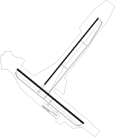
Runway info
Runway 4 / 22  | ||
| length | 1527m (5010ft) | |
| bearing | 47° / 227° | |
| width | 23m (75ft) | |
| surface | asphalt | |
| Runway 13 / 31 | ||
| length | 1526m (5007ft) | |
| bearing | 130° / 310° | |
| width | 30m (100ft) | |
| surface | asphalt | |
Nearby beacons
| code | identifier | dist | bearing | frequency |
|---|---|---|---|---|
| CTY | CROSS CITY VORTAC | 3.6 | 123° | 112 |
| LCQ | LAKE CITY NDB | 42.9 | 44° | 204 |
| GNV | GATORS VORTAC | 43.5 | 86° | 116.20 |
| GN | WYNDS (GAINESVILLE) NDB | 48.7 | 88° | 269 |
| OCF | OCALA VORTAC | 53.5 | 118° | 113.70 |
| TAY | TAYLOR VORTAC | 59.5 | 32° | 112.90 |
| GEF | GREENVILLE VORTAC | 65.3 | 323° | 109 |
Instrument approach procedures
| runway | airway (heading) | route (dist, bearing) |
|---|---|---|
| RW31 | CTY (303°) | CTY OKBIE (8mi, 135°) 2000ft OKBIE (turn) 2000ft |
| RW31 | ORATE (323°) | ORATE OKBIE (10mi, 336°) 2000ft |
| RNAV | OKBIE 2000ft HAMVU (6mi, 310°) 1600ft KCTY (5mi, 312°) 100ft (5045mi, 110°) 383ft WATKI (5049mi, 290°) ZEVEL (9mi, 48°) JUVIX (16mi, 130°) OKBIE (9mi, 228°) 2000ft OKBIE (turn) | |
| RWNVA | CEDDI (339°) | CEDDI ZOSDA (15mi, 308°) 2000ft UGLUF (5mi, 310°) 2000ft |
| RWNVA | HEVVN (103°) | HEVVN COVEP (34mi, 114°) 2000ft UGLUF (5mi, 130°) 2000ft |
| RWNVA | UGLUF (48°) | UGLUF 2000ft |
| RNAV | UGLUF 2000ft JEGIB (6mi, 47°) 1600ft KCTY (5mi, 48°) 94ft (5045mi, 110°) 442ft HULEL (5038mi, 290°) 2000ft HULEL (turn) | |
| RWNVB | ALVIN (184°) | ALVIN ZOTRO (19mi, 172°) 2000ft HULEL (5mi, 130°) 2000ft |
| RWNVB | GNV (266°) | GNV NITDI (32mi, 272°) 2100ft HULEL (5mi, 310°) 2000ft |
| RWNVB | HULEL (227°) | HULEL 2000ft |
| RNAV | HULEL 2000ft WIRET (6mi, 228°) 1600ft KCTY (5mi, 227°) 95ft (5045mi, 110°) 442ft UGLUF (5053mi, 290°) 2000ft UGLUF (turn) |
Disclaimer
The information on this website is not for real aviation. Use this data with the X-Plane flight simulator only! Data taken with kind consent from X-Plane 12 source code and data files. Content is subject to change without notice.