Clinton - Clinton Muni
Airport details
| Country | United States of America |
| State | Iowa |
| Region | K3 |
| Airspace | Chicago Ctr |
| Municipality | Clinton |
| Elevation | 708ft (216m) |
| Timezone | GMT -6 |
| Coordinates | 41.83075, -90.32897 |
| Magnetic var | |
| Type | land |
| Available since | X-Plane v10.40 |
| ICAO code | KCWI |
| IATA code | CWI |
| FAA code | CWI |
Communication
| Clinton Muni AWOS 3 | 125.525 |
| Clinton Muni CTAF/UNICOM | 122.800 |
Approach frequencies
| ILS-cat-I | RW03 | 109.7 | 18.00mi |
| 3° GS | RW03 | 109.7 | 18.00mi |
Nearby Points of Interest:
Horace Anthony House
-Peter Dierks House
-Cherry Bank
-George M. Curtis House
-Clinton High School and Public Library
-Clinton Public Library
-Wilson Building
-Washington Junior High School and Jefferson Grade School
-First National Bank
-Moeszinger-Marquis Hardware Co.
-Ankeny Building
-Howes Building
-Clinton County Courthouse
-Lock and Dam No. 13
-Buffalo Bill Cody Homestead
-Community Building
-Lafayette Lamb House
-Wilson District No. 7 School
-John H. Suiter House
-Kattenbracher House
-George Tromley, Sr., House
-Stone House
-Cody Road Historic District
-Rambo House
-Samuel Van Sant House
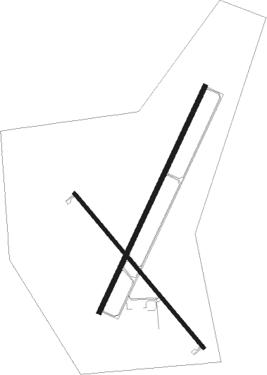
Runway info
Runway 3 / 21  | ||
| length | 1590m (5217ft) | |
| bearing | 37° / 217° | |
| width | 32m (105ft) | |
| surface | concrete | |
| Runway 14 / 32 | ||
| length | 1282m (4206ft) | |
| bearing | 136° / 316° | |
| width | 24m (79ft) | |
| surface | concrete | |
Nearby beacons
| code | identifier | dist | bearing | frequency |
|---|---|---|---|---|
| FN | HILLZ (CLINTON) NDB | 5.4 | 218° | 517 |
| CVA | DAVENPORT VORTAC | 10 | 232° | 113.80 |
| DB | ZILOM (DUBUQUE) NDB | 31.9 | 331° | 341 |
| MZV | MOLINE VOR/DME | 33.6 | 211° | 114.40 |
| PLL | POLO VOR/DME | 36.8 | 80° | 111.20 |
| DBQ | DUBUQUE VORTAC | 38.2 | 326° | 115.80 |
| DDD | CITY DME | 46.2 | 240° | 116.50 |
| BDF | BRADFORD VORTAC | 52.3 | 132° | 114.70 |
| GBG | DME | 53.8 | 187° | 109.80 |
Instrument approach procedures
| runway | airway (heading) | route (dist, bearing) |
|---|---|---|
| RW03 | BILOX (85°) | BILOX YINUT (19mi, 101°) 3100ft WOGOG (5mi, 113°) 3100ft |
| RW03 | CVA (52°) | CVA WOGOG (3mi, 156°) 3100ft WOGOG (turn) 3100ft |
| RW03 | NOWSO (5°) | NOWSO YESUC (6mi, 355°) 3100ft WOGOG (5mi, 293°) 3100ft |
| RNAV | WOGOG 3100ft ZIPOG (6mi, 37°) 2500ft JUKLO (2mi, 37°) 1740ft KCWI (3mi, 38°) 747ft CUDMA (12mi, 37°) 2500ft CUDMA (turn) | |
| RW14 | CIDSO (108°) | CIDSO ORARE (8mi, 62°) 2500ft |
| RW14 | CVA (52°) | CVA ORARE (18mi, 356°) 2500ft ORARE (turn) 2500ft |
| RW14 | WACKS (221°) | WACKS REPRY (17mi, 255°) 2800ft ORARE (6mi, 242°) 2500ft |
| RNAV | ORARE 2500ft GOMAH (7mi, 136°) 2500ft EXUGE (4mi, 136°) 1340ft KCWI (2mi, 133°) 741ft (5420mi, 115°) 951ft BELRE (5412mi, 295°) 2500ft BELRE (turn) | |
| RW21 | LOTTE (115°) | LOTTE CUDMA (17mi, 79°) 2500ft CUDMA (turn) 2500ft |
| RW21 | PACAF (252°) | PACAF CUDMA (12mi, 281°) 2500ft |
| RW21 | WACKS (221°) | WACKS CUDMA (12mi, 225°) 2500ft |
| RNAV | CUDMA 2500ft XOLDY (6mi, 217°) 2400ft OYUYA (3mi, 217°) 1380ft KCWI (3mi, 217°) 748ft (5420mi, 115°) 958ft WIKES (5422mi, 295°) CVA (6mi, 241°) 3000ft CVA (turn) | |
| RW32 | BELRE (317°) | BELRE 2500ft |
| RW32 | ENAME (286°) | ENAME BELRE (10mi, 242°) 2500ft |
| RW32 | NOWSO (5°) | NOWSO BELRE (12mi, 62°) 2500ft |
| RNAV | BELRE 2500ft ADIKE (8mi, 316°) 2500ft KCWI (6mi, 317°) 730ft (5420mi, 115°) 947ft ORARE (5428mi, 295°) 2500ft ORARE (turn) |
Disclaimer
The information on this website is not for real aviation. Use this data with the X-Plane flight simulator only! Data taken with kind consent from X-Plane 12 source code and data files. Content is subject to change without notice.