Bennington - William H Morse State
Airport details
| Country | United States of America |
| State | Vermont |
| Region | K6 |
| Airspace | Boston Ctr |
| Municipality | Bennington |
| Elevation | 827ft (252m) |
| Timezone | GMT -5 |
| Coordinates | 42.89119, -73.24609 |
| Magnetic var | |
| Type | land |
| Available since | X-Plane v10.40 |
| ICAO code | KDDH |
| IATA code | n/a |
| FAA code | DDH |
Communication
| William H Morse State ASOS | 135.925 |
| William H Morse State CTAF/UNICOM | 122.800 |
| William H Morse State ALBANY Approach/Departure | 125.000 |
Nearby Points of Interest:
Henry House
-H.C. White Company Mill Complex
-Bennington station
-Bennington Post Office
-Ritchie Block
-Old Bennington High School
-Carrigan Lane Historic District
-W. H. Bradford Hook and Ladder Fire House
-David Mathews House
-Robert Frost Farm
-Furnace Grove Historic District
-Breese-Reynolds House
-Bennington Fish Hatchery
-Munro-Hawkins House
-United States Post Office
-Hoosick Falls Historic District
-Hoosick Falls Armory
-Estabrook Octagon House
-Tibbits House
-Delaney Hotel
-White Creek Historic District
-Dickinson Hill Fire Tower
-Col. Benjamin Simond House
-Williamstown Rail Yard and Station Historic District
-United States Post Office–Williamstown Main
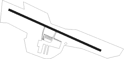
Runway info
| Runway 13 / 31 | ||
| length | 1127m (3698ft) | |
| bearing | 112° / 292° | |
| width | 23m (75ft) | |
| surface | asphalt | |
Nearby beacons
| code | identifier | dist | bearing | frequency |
|---|---|---|---|---|
| CAM | CAMBRIDGE VOR/DME | 7.5 | 316° | 115 |
| AL | HAWKY (ALBANY) NDB | 25.1 | 263° | 219 |
| ALB | ALBANY VORTAC | 26 | 256° | 115.30 |
| GF | GANSE (GLENS FALLS) NDB | 26.9 | 315° | 209 |
| HEU | HUNTER (SCHENECTADY) NDB | 30.3 | 267° | 356 |
| CTR | CHESTER VOR/DME | 38.3 | 154° | 115.10 |
| RUT | DME | 40.3 | 25° | 111 |
| EEN | DME | 42.4 | 96° | 109.40 |
| PFH | PHILMONT (HUDSON) NDB | 43.7 | 217° | 272 |
| CNH | CLAREMONT NDB | 47.9 | 61° | 233 |
| BAF | BARNES (WESTFIELD/SPRINGF VORTAC | 49.6 | 144° | 113 |
| DYO | SMUTO (RUTLAND) NDB | 50.5 | 20° | 221 |
| CEF | WESTOVER(SPRINGFIELD/CHIC TACAN | 52.4 | 134° | 114 |
Instrument approach procedures
| runway | airway (heading) | route (dist, bearing) |
|---|---|---|
| RW13 | FAXIB (112°) | FAXIB 4000ft |
| RW13 | GADYE (128°) | GADYE FAXIB (5mi, 216°) 4000ft |
| RW13 | JOTOV (97°) | JOTOV FAXIB (5mi, 36°) 4000ft |
| RNAV | FAXIB 4000ft CIBTA (10mi, 112°) 2400ft KDDH (5mi, 112°) 839ft (4673mi, 120°) 1227ft FAXIB (4687mi, 300°) 4000ft FAXIB (turn) |
Disclaimer
The information on this website is not for real aviation. Use this data with the X-Plane flight simulator only! Data taken with kind consent from X-Plane 12 source code and data files. Content is subject to change without notice.