Dothan - Dothan Rgnl
Airport details
| Country | United States of America |
| State | Alabama |
| Region | K7 |
| Airspace | Jacksonville Ctr |
| Municipality | Dothan |
| Elevation | 397ft (121m) |
| Timezone | GMT -6 |
| Coordinates | 31.32366, -85.45126 |
| Magnetic var | |
| Type | land |
| Available since | X-Plane v10.40 |
| ICAO code | KDHN |
| IATA code | DHN |
| FAA code | DHN |
Communication
| Dothan Rgnl ATIS | 135.725 |
| Dothan Rgnl CTAF | 118.400 |
| Dothan Rgnl UNICOM | 122.950 |
| Dothan Rgnl Ground Control | 121.700 |
| Dothan Rgnl Tower | 118.400 |
| Dothan Rgnl CAIRNS Approach/Departure | 125.400 |
| Dothan Rgnl Departure | 118.400 |
Approach frequencies
| ILS-cat-I | RW32 | 108.3 | 18.00mi |
| ILS-cat-I | RW14 | 110.75 | 18.00mi |
| 3° GS | RW32 | 108.3 | 18.00mi |
| 3° GS | RW14 | 110.75 | 18.00mi |
Nearby Points of Interest:
Federal Building and United States Courthouse
-Purcell-Killingsworth House
-Kennedy House
-Seaboard Coastline Depot
-Dill House
-Early County Courthouse
-Blakely Court Square Historic District
-Keith Cabin
-Erwin House
-Pender's Store
-Great Oaks
-Coffee County Courthouse
-Henry D. Clayton House
-Chipley City Hall
-Miller-Martin Town House
-Grace Episcopal Church
-South Third Street Historic District
-Petty-Roberts-Beatty House
-Seminole County Courthouse
-Fendall Hall
-Joseph W. Russ Jr. House
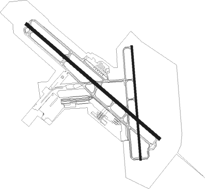
Runway info
Runway 14 / 32  | ||
| length | 2594m (8510ft) | |
| bearing | 131° / 311° | |
| width | 46m (150ft) | |
| surface | asphalt | |
| Runway 18 / 36 | ||
| length | 1681m (5515ft) | |
| bearing | 180° / 360° | |
| width | 30m (100ft) | |
| surface | asphalt | |
| displ threshold | 152m (499ft) / 0m (0ft) | |
Nearby beacons
| code | identifier | dist | bearing | frequency |
|---|---|---|---|---|
| RRS | WIREGRASS (DOTHAN) VORTAC | 2.5 | 153° | 111.60 |
| HEY | HANCHEY (FT RUCKER) VOR | 10.7 | 284° | 110.60 |
| HYE | HANCHEY (FT RUCKER) NDB | 10.8 | 285° | 221 |
| OZR | CAIRNS (FT RUCKER) VOR/DME | 14.4 | 259° | 111.20 |
| LOR | LOWE (FORT RUCKER) NDB | 15.1 | 277° | 269 |
| OZ | RUCKR (FT RUCKER) NDB | 19.6 | 255° | 212 |
| EDN | ENTERPRISE VOR | 23.2 | 267° | 116.60 |
| BVG | BOLL WEEVIL (ENTERPRISE) NDB | 27.2 | 272° | 352 |
| SMY | SOYYA (MARIANNA) NDB | 29.5 | 153° | 329 |
| MAI | MARIANNA VORTAC | 36.3 | 149° | 114 |
| EUF | EUFAULA VORTAC | 41 | 27° | 109.20 |
| TOI | BLOOD (TROY) NDB | 45.2 | 308° | 365 |
| JUY | JUDD (ANDALUSIA) NDB | 48.2 | 269° | 264 |
| LYZ | WILLIS (BAINBRIDGE) NDB | 52 | 111° | 359 |
| AWS | LAWSON (COLUMBUS) NDB | 62.1 | 24° | 335 |
| PFN | LYNNE (PANAMA CITY) NDB | 62.2 | 198° | 278 |
| MGM | MONTGOMERY VORTAC | 69.8 | 316° | 112.10 |
Instrument approach procedures
| runway | airway (heading) | route (dist, bearing) |
|---|---|---|
| RW14 | MUNEE (130°) | MUNEE 2500ft |
| RNAV | MUNEE 2500ft USERY (7mi, 130°) 2000ft ZOPSO (2mi, 131°) 1200ft KDHN (3mi, 129°) 455ft (5172mi, 110°) 900ft OALDY (5157mi, 290°) 3000ft OALDY (turn) | |
| RW18 | UMELY (182°) | UMELY 2700ft |
| RNAV | UMELY 2700ft WAPCE (7mi, 180°) 2000ft ZUMIN (2mi, 180°) 1260ft KDHN (3mi, 187°) 438ft (5172mi, 110°) 900ft OALDY (5157mi, 290°) 3000ft OALDY (turn) | |
| RW32 | JAPIX (311°) | JAPIX 3000ft |
| RNAV | JAPIX 3000ft BASME (7mi, 311°) 2200ft FEKRA (3mi, 311°) 1280ft KDHN (3mi, 312°) 439ft (5172mi, 110°) 900ft HAVSO (5166mi, 290°) 3000ft HAVSO (turn) | |
| RW36 | VIMLY (358°) | VIMLY 2500ft |
| RNAV | VIMLY 2500ft QEDLU (7mi, 360°) 2000ft INUME (3mi, 360°) 960ft KDHN (2mi, 352°) 430ft (5172mi, 110°) 900ft HAVSO (5166mi, 290°) 3000ft HAVSO (turn) |
Disclaimer
The information on this website is not for real aviation. Use this data with the X-Plane flight simulator only! Data taken with kind consent from X-Plane 12 source code and data files. Content is subject to change without notice.