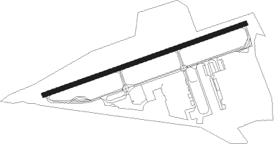
Knoxville - Knoxville Downtown Island
Airport details
| Country | United States of America |
| State | Tennessee |
| Region | K7 |
| Airspace | Atlanta Ctr |
| Municipality | Knoxville |
| Elevation | 833ft (254m) |
| Timezone | GMT -5 |
| Coordinates | 35.96270, -83.87296 |
| Magnetic var | |
| Type | land |
| Available since | X-Plane v10.40 |
| ICAO code | KDKX |
| IATA code | DKX |
| FAA code | DKX |
Communication
| Knoxville Downtown Island AWOS 3 | 125.375 |
| Knoxville Downtown Island CTAF | 126.600 |
| Knoxville Downtown Island Approach/Departure | 123.900 |
Approach frequencies
| LOC | RW26 | 111.3 | 18.00mi |
Nearby Points of Interest:
Colonel John Williams House
-General John T. Wilder House
-Samuel McCammon House
-Lebanon in the Forks Cemetery
-South Market Historic District
-Craighead-Jackson House
-Lindbergh Forest
-Knox County Courthouse
-Mechanics' Bank and Trust Company Building
-Monday House
-Fidelity Building
-The Holston
-Gay Street
-General Building
-James Park House
-United States Post Office and Courthouse
-Tennessee Theatre
-Medical Arts Building
-Jackson Avenue Warehouse District
-Market Square
-Southern Terminal
-Daylight Building
-Caswell–Taylor House
-Isaac Ziegler House
-Old City Hall
Nearby beacons
| code | identifier | dist | bearing | frequency |
|---|---|---|---|---|
| VXV | VOLUNTEER (KNOXVILLE) VORTAC | 3.6 | 201° | 116.40 |
| JXT | JEFFERSON (MORRISTOWN) NDB | 21.2 | 70° | 346 |
| SOT | SNOWBIRD VORTAC | 41.2 | 102° | 108.80 |
| SCX | SCOTT (ONEIDA) NDB | 45.5 | 305° | 403 |
| RVN | ROGERSVILLE NDB | 56.3 | 63° | 329 |
Instrument approach procedures
| runway | airway (heading) | route (dist, bearing) |
|---|---|---|
| RW26 | MALIN (203°) | MALIN JISIT (9mi, 137°) 5100ft SPROC (5mi, 162°) 3500ft |
| RW26 | NOISE (161°) | NOISE JISIT (16mi, 106°) 5100ft SPROC (5mi, 162°) 3500ft |
| RW26 | PITTE (284°) | PITTE YEBUB (12mi, 295°) 5100ft SPROC (5mi, 342°) 3500ft |
| RW26 | WHINS (258°) | WHINS SPROC (17mi, 257°) 3500ft |
| RNAV | SPROC 3500ft CIXUG (7mi, 258°) 2500ft KDKX (5mi, 257°) 863ft (5108mi, 113°) 1233ft ZIRNI (5109mi, 293°) SWASO (18mi, 255°) 4000ft SWASO (turn) |
Disclaimer
The information on this website is not for real aviation. Use this data with the X-Plane flight simulator only! Data taken with kind consent from X-Plane 12 source code and data files. Content is subject to change without notice.