Augusta - Daniel Fld
Airport details
| Country | United States of America |
| State | Georgia |
| Region | K7 |
| Airspace | Atlanta Ctr |
| Municipality | Augusta |
| Elevation | 419ft (128m) |
| Timezone | GMT -5 |
| Coordinates | 33.46658, -82.03939 |
| Magnetic var | |
| Type | land |
| Available since | X-Plane v10.40 |
| ICAO code | KDNL |
| IATA code | DNL |
| FAA code | DNL |
Communication
| Daniel Fld ASOS | 135.275 |
| Daniel Fld CTAF/UNICOM | 123.050 |
| Daniel Fld AUGUSTA Approach/Departure | 126.800 |
Nearby Points of Interest:
Stephen Vincent Benét House
-College Hill
-Reid-Jones-Carpenter House
-Sand Hills Historic District
-Shiloh Orphanage
-Augusta National Golf Club
-Augusta Canal
-Meadow Garden
-Sacred Heart Cultural Center
-United States Post Office and Courthouse
-First Baptist Church
-Woodrow Wilson Boyhood Home
-Joseph Rucker Lamar Boyhood Home
-Lamar Building
-Augusta Downtown Historic District
-Rosemary Hall
-Brahe House
-B.C. Wall House
-Old Government House
-Lookaway Hall
-Charles Hammond House
-Seclusaval and Windsor Spring
-The Cedars
-Hopewell Rosenwald School
-Oakland Plantation (Beech Island, South Carolina)
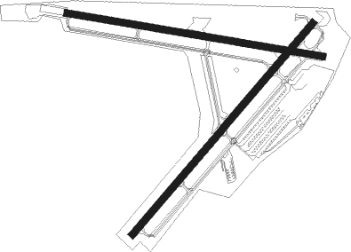
Runway info
Runway 5 / 23  | ||
| length | 1221m (4006ft) | |
| bearing | 50° / 230° | |
| width | 30m (100ft) | |
| surface | asphalt | |
| displ threshold | 61m (200ft) / 88m (289ft) | |
| blast zone | 0m (0ft) / 46m (151ft) | |
| Runway 11 / 29 | ||
| length | 1138m (3734ft) | |
| bearing | 102° / 282° | |
| width | 30m (100ft) | |
| surface | asphalt | |
| displ threshold | 99m (325ft) / 96m (315ft) | |
| blast zone | 122m (400ft) / 61m (200ft) | |
Nearby beacons
| code | identifier | dist | bearing | frequency |
|---|---|---|---|---|
| EMR | EMORY (AUGUSTA) NDB | 2.1 | 95° | 385 |
| AG | BUSHE (AUGUSTA) NDB | 11.7 | 153° | 233 |
| IRQ | COLLIERS VORTAC | 15.7 | 333° | 113.90 |
| AIK | AIKEN NDB | 21.2 | 63° | 347 |
| AA | CEDAR (THOMSON) NDB | 29 | 277° | 341 |
| ALD | ALLENDALE VOR | 46.3 | 121° | 116.70 |
| GIW | CORONACA (GREENWOOD) NDB | 47.3 | 357° | 239 |
| GRD | GREENWOOD VORTAC | 47.4 | 352° | 115.50 |
| CA | MURRY (COLUMBIA) NDB | 49.7 | 58° | 362 |
| VV | JUNNE (GREENSBORO) NDB | 50.3 | 280° | 353 |
| EEX | EMANUEL COUNTY (SWAINSBORO) NDB | 52.3 | 207° | 309 |
| JYL | SYLVANIA NDB | 53.9 | 151° | 245 |
| CAE | COLUMBIA VORTAC | 54.5 | 68° | 114.70 |
| EOE | ENOREE (NEWBERRY) NDB | 54.5 | 26° | 278 |
| DBN | DUBLIN VORTAC | 67.2 | 221° | 113.10 |
| ELW | ELECTRIC CITY (ANDERSON) VORTAC | 68.2 | 322° | 108.60 |
Departure and arrival routes
| Transition altitude | 18000ft |
| Transition level | 18000ft |
| SID end points | distance | outbound heading | |
|---|---|---|---|
| ALL | |||
| CHATT6 | 107mi | 13° | |
| AZALA4, MISTY6, NDINA5, SAMMI4 | 26mi | 59° | |
Instrument approach procedures
| runway | airway (heading) | route (dist, bearing) |
|---|---|---|
| RW11-Y | FOGOB (77°) | FOGOB JODVU (6mi, 16°) 2100ft |
| RW11-Y | INIKE (129°) | INIKE JODVU (6mi, 196°) 2100ft |
| RW11-Y | JODVU (102°) | JODVU 2100ft |
| RNAV | JODVU 2100ft JITOL (7mi, 101°) 2000ft KDNL (4mi, 103°) 476ft (5007mi, 112°) 1400ft JODVU (5018mi, 292°) 2100ft JODVU (turn) |
Disclaimer
The information on this website is not for real aviation. Use this data with the X-Plane flight simulator only! Data taken with kind consent from X-Plane 12 source code and data files. Content is subject to change without notice.