Des Moines - Des Moines Intl
Airport details
| Country | United States of America |
| State | Iowa |
| Region | K3 |
| Airspace | Minneapolis Ctr |
| Municipality | Des Moines |
| Elevation | 957ft (292m) |
| Timezone | GMT -6 |
| Coordinates | 41.53397, -93.66309 |
| Magnetic var | |
| Type | land |
| Available since | X-Plane v10.40 |
| ICAO code | KDSM |
| IATA code | DSM |
| FAA code | DSM |
Communication
| Des Moines Intl ATIS | 119.550 |
| Des Moines Intl UNICOM | 122.950 |
| Des Moines Intl Clearance DEL | 134.150 |
| Des Moines Intl Ground Control | 121.900 |
| Des Moines Intl Tower | 118.300 |
| Des Moines Intl Approach/Departure | 135.200 |
| Des Moines Intl Approach/Departure | 118.600 |
| Des Moines Intl Approach/Departure | 123.900 |
Approach frequencies
| ILS-cat-III | RW31 | 110.3 | 18.00mi |
| ILS-cat-I | RW05 | 111.5 | 18.00mi |
| ILS-cat-I | RW13 | 111.9 | 18.00mi |
| 3° GS | RW31 | 110.3 | 18.00mi |
| 3° GS | RW05 | 111.5 | 18.00mi |
| 3° GS | RW13 | 111.9 | 18.00mi |
Nearby Points of Interest:
Mary A. and Caleb D. Scott House
-Boyt Company Building
-Byron and Ivan Boyd House
-Jay Norwood and Genevieve Pendleton Darling House
-Valley Junction-West Des Moines City Hall and Engine House
-Valley Junction Commercial Historic District
-Albert Baird Cummins House
-I.O.O.F. Valley Junction Lodge Hall No. 604
-Herndon Hall
-F. W. Fitch Company Historic District
-Plymouth Place
-Mahnke House
-Ingersoll Place Plat Historic District
-Studebaker Corporation Branch Office Building
-Crane Building
-G.W. Jones Building
-Apperson-Iowa Motor Car Company Building
-Schmitt and Henry Manufacturing Company
-D.S. Chamberlain Building
-National Biscuit Company Building
-Hallett Flats–Rawson & Co. Apartment Building
-Grocers Wholesale Company Building
-Hubbell Warehouse
-Clemens Automobile Company Building
-Herring Motor Car Company Building
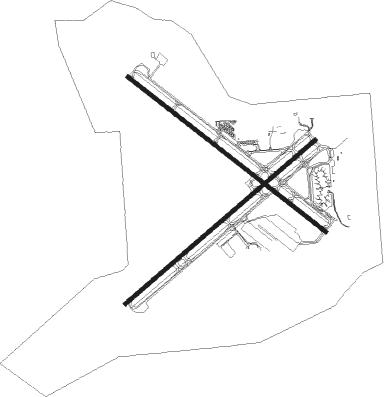
Runway info
Runway 5 / 23  | ||
| length | 2744m (9003ft) | |
| bearing | 61° / 241° | |
| width | 46m (150ft) | |
| surface | asphalt | |
| blast zone | 61m (200ft) / 213m (699ft) | |
| Runway 13 / 31 | ||
| length | 2751m (9026ft) | |
| bearing | 124° / 304° | |
| width | 46m (150ft) | |
| surface | asphalt | |
| blast zone | 152m (499ft) / 152m (499ft) | |
Nearby beacons
| code | identifier | dist | bearing | frequency |
|---|---|---|---|---|
| DSM | DES MOINES VORTAC | 5.8 | 171° | 117.50 |
| TNU | NEWTON VOR/DME | 29 | 66° | 112.50 |
| PEA | PELLA NDB | 33.2 | 100° | 257 |
| EFW | JEFFERSON NDB | 41.9 | 305° | 391 |
| JWJ | ELMWOOD (MARSHALTOWN) VOR/DME | 48.3 | 53° | 109.40 |
| LMN | LAMONI VOR/DME | 57.9 | 198° | 116.70 |
| FO | BARRO (FORT DODGE) NDB | 65.4 | 327° | 341 |
Departure and arrival routes
| Transition altitude | 18000ft |
| Transition level | 18000ft |
| SID end points | distance | outbound heading | |
|---|---|---|---|
| RW05 | |||
| DSM1 | 11mi | 124° | |
| RW13 | |||
| DSM1 | 11mi | 124° | |
| RW23 | |||
| DSM1 | 11mi | 124° | |
| RW31 | |||
| DSM1 | 11mi | 124° | |
Instrument approach procedures
| runway | airway (heading) | route (dist, bearing) |
|---|---|---|
| RW05 | DELAY (61°) | DELAY 3000ft |
| RNAV | DELAY 3000ft MAARY (7mi, 61°) 2500ft CEDIP (3mi, 61°) 1480ft KDSM (2mi, 58°) 971ft (5570mi, 114°) 1131ft IOWAA (5560mi, 294°) 3100ft IOWAA (turn) | |
| RW13 | WATTY (125°) | WATTY 3500ft |
| RNAV | WATTY 3500ft CLIVE (8mi, 124°) 2600ft TILTH (3mi, 124°) 1500ft KDSM (3mi, 128°) 968ft (5570mi, 114°) 1122ft CYCLN (5562mi, 294°) 3000ft CYCLN (turn) | |
| RW23 | IOWAA (242°) | IOWAA 3100ft |
| RNAV | IOWAA 3100ft HERKY (6mi, 241°) 2600ft TUPNE (3mi, 241°) 1780ft KDSM (3mi, 244°) 991ft (5570mi, 114°) 1242ft DELAY (5580mi, 294°) 3000ft DELAY (turn) | |
| RW31 | CYCLN (304°) | CYCLN 3000ft |
| RNAV | CYCLN 3000ft FOREM (6mi, 305°) 2400ft KDSM (5mi, 303°) 1010ft (5570mi, 114°) 1158ft WATTY (5580mi, 294°) 3500ft WATTY (turn) |
Disclaimer
The information on this website is not for real aviation. Use this data with the X-Plane flight simulator only! Data taken with kind consent from X-Plane 12 source code and data files. Content is subject to change without notice.