Phoenix - Phoenix Deer Valley
Airport details
| Country | United States of America |
| State | Arizona |
| Region | K2 |
| Airspace | Albuquerque Ctr |
| Municipality | Phoenix |
| Elevation | 1478ft (450m) |
| Timezone | GMT -7 |
| Coordinates | 33.68644, -112.08298 |
| Magnetic var | |
| Type | land |
| Available since | X-Plane v10.40 |
| ICAO code | KDVT |
| IATA code | DVT |
| FAA code | DVT |
Communication
| Phoenix Deer Valley ATIS | 126.500 |
| Phoenix Deer Valley CTAF | 118.400 |
| Phoenix Deer Valley UNICOM | 122.950 |
| Phoenix Deer Valley Clearance | 123.900 |
| Phoenix Deer Valley Ground Control | 121.800 |
| Phoenix Deer Valley Deer Valley Tower 07R-25L | 118.400 |
| Phoenix Deer Valley Deer Valley Tower 07L-25R | 120.200 |
| Phoenix Deer Valley Approach | 120.700 |
| Phoenix Deer Valley Departure | 120.700 |
Nearby Points of Interest:
Louis J. Bohn and Gertrude Lee House
-Kinter K. Koontz House
-Sahuaro Ranch
-Manistee Ranch
-Ralph Converse House
-E. Payne Palmer House
-Catlin Court Historic District
-Floralcroft Historic District
-Brophy College Chapel
-Cave Creek Service Station
-Roald Amundsen
-Louise Lincoln Kerr House and Studio
-Phoenix Homesteads Historic District
-Edward L. Jones House
-Phoenix Towers
-Encanto-Palmcroft Historic District
-Rancho Joaquina House
-Smurthwaite House
-Helen Anderson House
-Temple Beth Israel
-Garfield Methodist Church
-Knights of Pythias Building
-United States Post Office in Phoenix
-J. T. Whitney Funeral Home
-Phoenix Union High School
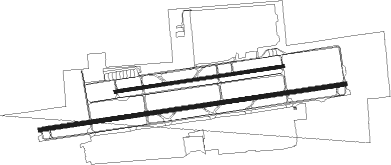
Runway info
Runway 7R / 25L  | ||
| length | 2495m (8186ft) | |
| bearing | 87° / 267° | |
| width | 30m (100ft) | |
| surface | asphalt | |
| displ threshold | 279m (915ft) / 282m (925ft) | |
| blast zone | 47m (154ft) / 46m (151ft) | |
| Runway 7L / 25R | ||
| length | 1369m (4491ft) | |
| bearing | 87° / 267° | |
| width | 23m (75ft) | |
| surface | asphalt | |
Nearby beacons
| code | identifier | dist | bearing | frequency |
|---|---|---|---|---|
| PXR | PHOENIX VORTAC | 16.2 | 156° | 115.60 |
| LUF | LUKE (GLENDALE) TACAN | 17.3 | 243° | 113 |
| IWA | WILLIE (PHOENIX) VORTAC | 31.5 | 132° | 113.30 |
| BXK | BUCKEYE VORTAC | 39.6 | 253° | 110.60 |
| TFD | STANFIELD (CASA GRANDE) VORTAC | 48.8 | 168° | 114.80 |
| PAN | DME | 50.5 | 53° | 116.35 |
| GBN | GILA BEND VORTAC | 52.9 | 219° | 116.60 |
Departure and arrival routes
| Transition altitude | 18000ft |
| Transition level | 18000ft |
| SID end points | distance | outbound heading | |
|---|---|---|---|
| RW07 (ALL) | |||
| DVT1 | 16mi | 156° | |
| RW25 (ALL) | |||
| SNOBL6, YOTES6 | 144mi | 40° | |
| LALUZ6 | 153mi | 76° | |
| FTHLS6 | 271mi | 83° | |
| KATMN6 | 167mi | 114° | |
| BNYRD6 | 112mi | 144° | |
| DVT1 | 16mi | 156° | |
| JUDTH7 | 110mi | 244° | |
| IZZZO7 | 86mi | 274° | |
| MAYSA7 | 81mi | 317° | |
| STAR starting points | distance | inbound heading | |
|---|---|---|---|
| ALL | |||
| ARLIN4, BLH5 | 38.6 | 56° | |
| DSERT2 | 49.9 | 209° | |
| SUNSS8 | 74.2 | 313° | |
Instrument approach procedures
| runway | airway (heading) | route (dist, bearing) |
|---|---|---|
| RW07R | BANYO (183°) | BANYO AZNUP (12mi, 262°) 5400ft BOLES (8mi, 175°) 3900ft |
| RNAV | BOLES 3900ft CEGAP (6mi, 87°) 2900ft JURUX (1mi, 87°) 2440ft KDVT (4mi, 88°) 1487ft (6500mi, 107°) 1795ft VIFPE (6499mi, 287°) AVENT (1mi, 82°) 5000ft AVENT (turn) | |
| RW25L | BANYO (183°) | BANYO CIPLU (18mi, 113°) 6300ft CIPLU (turn) 5600ft DUYAC (4mi, 267°) 5100ft |
| RW25L | POURS (202°) | POURS CIPLU (23mi, 155°) 8200ft CIPLU (turn) 5600ft DUYAC (4mi, 267°) 5100ft |
| RW25L | PXR (336°) | PXR CIPLU (20mi, 38°) 6300ft CIPLU (turn) 5600ft DUYAC (4mi, 267°) 5100ft |
| RNAV | DUYAC 5100ft FEGEV (2mi, 267°) 4700ft GIGEC (5mi, 267°) 2940ft KDVT (5mi, 266°) 1515ft BOLES (11mi, 267°) HEVRO (10mi, 321°) BANYO (17mi, 85°) 6000ft BANYO (turn) | |
| RWNVB | RADOM (218°) | RADOM SOQSY (8mi, 193°) 7500ft JAFBY (4mi, 193°) 5800ft KNOBB (6mi, 193°) 4600ft |
| RNAV | KNOBB 4600ft JERGI (6mi, 266°) 3100ft MIKSY (2mi, 266°) 2420ft (6499mi, 107°) 2420ft CEBEM (6511mi, 287°) HEVRO (10mi, 321°) BANYO (17mi, 85°) 6000ft BANYO (turn) |
Holding patterns
| STAR name | hold at | type | turn | heading* | altitude | leg | speed limit |
|---|---|---|---|---|---|---|---|
| ARLIN4 | ARLIN | VHF | right | 256 (76)° | 1.0min timed | ICAO rules | |
| ARLIN4 | HYDRR | VHF | right | 215 (35)° | 1.0min timed | ICAO rules | |
| BLH5 | ARLIN | VHF | right | 256 (76)° | 1.0min timed | ICAO rules | |
| BLH5 | HYDRR | VHF | right | 215 (35)° | 1.0min timed | ICAO rules | |
| DSERT2 | DSERT | VHF | left | 345 (165)° | DME 10.0mi | ICAO rules | |
| DSERT2 | SHOCK | VHF | left | 2 (182)° | DME 10.0mi | ICAO rules | |
| SUNSS8 | BAYBI | VHF | left | 120 (300)° | DME 9.0mi | ICAO rules | |
| SUNSS8 | ITEMM | VHF | left | 93 (273)° | DME 10.0mi | ICAO rules | |
| SUNSS8 | SQUEZ | VHF | left | 120 (300)° | DME 7.0mi | ICAO rules | |
| *) magnetic outbound (inbound) holding course | |||||||
Disclaimer
The information on this website is not for real aviation. Use this data with the X-Plane flight simulator only! Data taken with kind consent from X-Plane 12 source code and data files. Content is subject to change without notice.