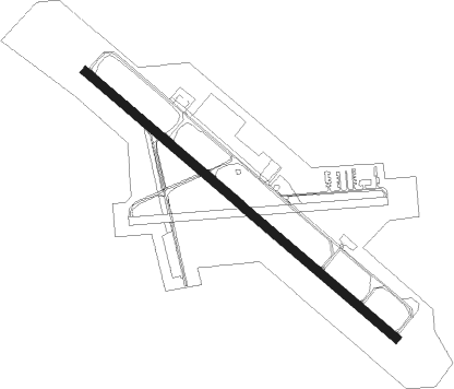
Wenatchee - Pangborn Memorial
Airport details
| Country | United States of America |
| State | Washington |
| Region | K1 |
| Airspace | Seattle Ctr |
| Municipality | Douglas County |
| Elevation | 1249ft (381m) |
| Timezone | GMT -8 |
| Coordinates | 47.39809, -120.20573 |
| Magnetic var | |
| Type | land |
| Available since | X-Plane v10.40 |
| ICAO code | KEAT |
| IATA code | EAT |
| FAA code | EAT |
Communication
| Pangborn Memorial ASOS | 119.925 |
| Pangborn Memorial CTAF/UNICOM | 123.000 |
Approach frequencies
| ILS-cat-I | RW12 | 109.35 | 18.00mi |
| 3.6° GS | RW12 | 109.35 | 18.00mi |
Nearby Points of Interest:
Senator George Sellar Bridge
-Wenatchee Fire Station No. 1
-Douglas County Courthouse
-Badger Mountain Lookout
-Chelan Butte Lookout
-Leavenworth Ranger Station
-Chicago, Milwaukee, St. Paul & Pacific Railroad-Kittitas Depot
-Grant County Courthouse
Nearby beacons
| code | identifier | dist | bearing | frequency |
|---|---|---|---|---|
| EAT | WENATCHEE VOR/DME | 0.2 | 287° | 111 |
| ELN | ELLENSBURG (ELLENSBERG) VOR/DME | 24.6 | 214° | 117.90 |
| EPH | EPHRATA VORTAC | 31.8 | 91° | 112.60 |
| MWH | MOSES LAKE VOR/DME | 37.9 | 102° | 115 |
| MW | PELLY (MOSES LAKE) NDB | 41.5 | 107° | 408 |
| YKM | YAKIMA VORTAC | 50.6 | 196° | 116 |
Departure and arrival routes
| Transition altitude | 18000ft |
| Transition level | 18000ft |
| SID end points | distance | outbound heading | |
|---|---|---|---|
| RW12 | |||
| OFARO2 | 15mi | 145° | |
| ZARLO2 | 54mi | 287° | |
| RW30 | |||
| OFARO2 | 15mi | 145° | |
| ZARLO2 | 54mi | 287° | |
Instrument approach procedures
| runway | airway (heading) | route (dist, bearing) |
|---|---|---|
| RW12 | CASHS (92°) | CASHS ZUBEX (9mi, 93°) 6400ft VENJU (13mi, 52°) 5400ft WULIP (4mi, 312°) 5400ft FEMAM (7mi, 258°) 5200ft |
| RW12 | EPH (271°) | EPH JETNU (26mi, 290°) 6000ft WULIP (5mi, 290°) 5400ft FEMAM (7mi, 258°) 5200ft |
| RW12 | QUINT (302°) | QUINT VENJU (21mi, 343°) 5400ft WULIP (4mi, 312°) 5400ft FEMAM (7mi, 258°) 5200ft |
| RNAV | FEMAM 5200ft CIRZI (5mi, 218°) 3700ft YUBBU (2mi, 168°) KEAT (6mi, 124°) 1262ft JOKRU (7mi, 124°) QUINT (10mi, 120°) 5400ft QUINT (turn) | |
| RW30-Y | EAT (107°) | EAT FEXUS (7mi, 115°) 4900ft CRUMM (5mi, 115°) 4600ft CRUMM (turn) 4600ft |
| RW30-Y | EPH (271°) | EPH CRUMM (22mi, 260°) 4600ft |
| RW30-Y | QUINT (302°) | QUINT CRUMM (4mi, 327°) 4600ft |
| RNAV | CRUMM 4600ft CAMUR (7mi, 295°) 3200ft DOVME (3mi, 293°) 2020ft ERUME (1mi, 293°) 1461ft (6601mi, 112°) 3000ft DOVME (6600mi, 292°) CRUMM (10mi, 114°) 4600ft CRUMM (turn) | |
| RW30-Z | EAT (107°) | EAT VEDUC (9mi, 90°) 6000ft CORTH (9mi, 140°) 5000ft HESNI (7mi, 271°) 3900ft |
| RW30-Z | QUINT (302°) | QUINT HESNI (7mi, 292°) 3900ft |
| RW30-Z | ZAXUL (325°) | ZAXUL HESNI (6mi, 358°) 3900ft |
| RNAV | HESNI 3900ft DOOGI (6mi, 323°) 3000ft CUKSI (1mi, 291°) YURLU (turn) KEAT (2mi, 304°) 1292ft KULOC (5mi, 304°) FEXUB (6mi, 63°) QUINT (21mi, 140°) 6000ft QUINT (turn) |
Disclaimer
The information on this website is not for real aviation. Use this data with the X-Plane flight simulator only! Data taken with kind consent from X-Plane 12 source code and data files. Content is subject to change without notice.
