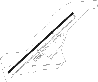
Enterprise - Enterprise Muni
Airport details
| Country | United States of America |
| State | Alabama |
| Region | K7 |
| Airspace | Jacksonville Ctr |
| Municipality | Coffee County |
| Elevation | 359ft (109m) |
| Timezone | GMT -5 |
| Coordinates | 31.29972, -85.89983 |
| Magnetic var | |
| Type | land |
| Available since | X-Plane v10.40 |
| ICAO code | KEDN |
| IATA code | ETS |
| FAA code | EDN |
Communication
| Enterprise Muni CTAF/UNICOM | 122.800 |
| Enterprise Muni CAIRNS Approach/Departure | 133.450 |
Nearby Points of Interest:
Seaboard Coastline Depot
-Coffee County Courthouse
-Keith Cabin
-Brantley Historic District
-Federal Building and United States Courthouse
-Avant House (Andalusia, Alabama)
-Covington County Courthouse and Jail
-Bank of Andalusia
-College Street Historic District
-Luverne Historic District
Nearby beacons
| code | identifier | dist | bearing | frequency |
|---|---|---|---|---|
| EDN | ENTERPRISE VOR | 0.2 | 221° | 116.60 |
| BVG | BOLL WEEVIL (ENTERPRISE) NDB | 4.8 | 296° | 352 |
| OZ | RUCKR (FT RUCKER) NDB | 6.1 | 131° | 212 |
| LOR | LOWE (FORT RUCKER) NDB | 8.8 | 68° | 269 |
| OZR | CAIRNS (FT RUCKER) VOR/DME | 9 | 100° | 111.20 |
| HEY | HANCHEY (FT RUCKER) VOR | 13.4 | 73° | 110.60 |
| HYE | HANCHEY (FT RUCKER) NDB | 13.4 | 73° | 221 |
| RRS | WIREGRASS (DOTHAN) VORTAC | 24 | 92° | 111.60 |
| JUY | JUDD (ANDALUSIA) NDB | 25.2 | 271° | 264 |
| TOI | BLOOD (TROY) NDB | 33.5 | 339° | 365 |
| CE | KOBRA (CRESTVIEW) NDB | 42.3 | 235° | 201 |
| SMY | SOYYA (MARIANNA) NDB | 43.1 | 122° | 329 |
| CEW | CRESTVIEW VORTAC | 49.1 | 239° | 115.90 |
| MAI | MARIANNA VORTAC | 50.4 | 124° | 114 |
| EUF | EUFAULA VORTAC | 55.4 | 50° | 109.20 |
| PFN | LYNNE (PANAMA CITY) NDB | 58.7 | 173° | 278 |
| DWG | WARRINGTON (VALPARAISO) TACAN | 58.8 | 217° | 134.50 |
| MGM | MONTGOMERY VORTAC | 59.4 | 336° | 112.10 |
| HRT | HURLBURT (MARY ESTHER) TACAN | 66.3 | 222° | 110.80 |
| AWS | LAWSON (COLUMBUS) NDB | 74.5 | 41° | 335 |
Instrument approach procedures
| runway | airway (heading) | route (dist, bearing) |
|---|---|---|
| RW05 | IWAVE (29°) | IWAVE 2500ft ROTOY (5mi, 318°) 2500ft |
| RW05 | JAYSZ (79°) | JAYSZ 2500ft ROTOY (5mi, 138°) 2500ft |
| RW05 | ROTOY (56°) | ROTOY 2500ft |
| RNAV | ROTOY 2500ft ADWEL (6mi, 56°) 1600ft KEDN (4mi, 56°) 382ft CEYLU (7mi, 56°) HAXES (12mi, 289°) ROTOY (15mi, 189°) 2500ft ROTOY (turn) |
Disclaimer
The information on this website is not for real aviation. Use this data with the X-Plane flight simulator only! Data taken with kind consent from X-Plane 12 source code and data files. Content is subject to change without notice.