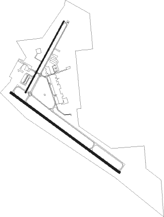
Kerrville - Kerrville Muni Louis Schreiner Fld
Airport details
| Country | United States of America |
| State | Texas |
| Region | K4 |
| Airspace | Houston Oceanic Ctr |
| Municipality | Kerrville |
| Elevation | 1617ft (493m) |
| Timezone | GMT -6 |
| Coordinates | 29.97902, -99.08692 |
| Magnetic var | |
| Type | land |
| Available since | X-Plane v10.40 |
| ICAO code | KERV |
| IATA code | ERV |
| FAA code | ERV |
Communication
| KERRVILLE MUNI LOUIS SCHREINER FLD Kerrville AWOS-3 | 118.125 |
| KERRVILLE MUNI LOUIS SCHREINER FLD Kerrville CTAF/UNICOM | 122.700 |
Approach frequencies
| LOC | RW30 | 109.1 | 18.00mi |
Nearby Points of Interest:
Masonic Building
-Capt. Charles Schreiner Mansion
-Old Camp Verde
-Otto Brinkmann House
-Comfort Historic District
-Wrede School
-HA. 19
-Frank Van Der Stucken Birthplace
-Fredericksburg Memorial Library
-Hoerster Building
-Fredericksburg Historic District
-Kendall County Courthouse and Jail
-Cave Without a Name
-Williams Creek School
-Lyndon B. Johnson National Historical Park
-Trinity Lutheran Church
-Reconstructed Birthplace
-Cherry Spring School
-Crabapple School

Nearby beacons
| code | identifier | dist | bearing | frequency |
|---|---|---|---|---|
| CSI | CENTER POINT (KERRVILLE) VORTAC | 7.4 | 246° | 117.50 |
| STV | STONEWALL VORTAC | 24 | 59° | 113.80 |
| AN | ALAMO (SAN ANTONIO) NDB | 34.9 | 126° | 368 |
| SAT | SAN ANTONIO VORTAC | 38.3 | 118° | 116.80 |
| KSY | KELLY (SAN ANTONIO) TACAN | 44 | 139° | 112 |
| RND | RANDOLPH VORTAC | 50.1 | 120° | 112.30 |
| DHK | RANDOLPH TACAN | 50.2 | 118° | 109.90 |
| HHH | DEVINE NDB | 51 | 170° | 359 |
| LLO | LLANO VORTAC | 51.4 | 20° | 108.20 |
| JCT | JUNCTION VORTAC | 53 | 310° | 116 |
| SSF | STINSON (SAN ANTONIO) VOR | 54.7 | 138° | 108.40 |
Instrument approach procedures
| runway | airway (heading) | route (dist, bearing) |
|---|---|---|
| RW12 | OBUCO (126°) | OBUCO 4000ft |
| RNAV | OBUCO 4000ft LAVIC (7mi, 127°) 3300ft HALOL (2mi, 127°) 2500ft KERV (3mi, 123°) 1616ft (5877mi, 107°) 1836ft DIYER (5869mi, 287°) 4100ft DIYER (turn) | |
| RW30 | CSI (66°) | CSI JAMPI (15mi, 120°) 4100ft DIYER (5mi, 44°) 4100ft |
| RW30 | DIYER (308°) | DIYER 4100ft |
| RW30 | STV (239°) | STV FIMEL (19mi, 206°) 4100ft DIYER (5mi, 225°) 4100ft |
| RNAV | DIYER 4100ft RITRE (6mi, 307°) 3300ft KERV (6mi, 308°) 1634ft (5877mi, 107°) 1860ft OBUCO (5886mi, 287°) 4000ft OBUCO (turn) |
Disclaimer
The information on this website is not for real aviation. Use this data with the X-Plane flight simulator only! Data taken with kind consent from X-Plane 12 source code and data files. Content is subject to change without notice.