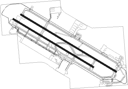
Fresno - Fresno Air Terminal
Airport details
| Country | United States of America |
| State | California |
| Region | K2 |
| Airspace | Oakland Ctr |
| Municipality | Fresno |
| Elevation | 333ft (101m) |
| Timezone | GMT -8 |
| Coordinates | 36.78380, -119.71906 |
| Magnetic var | |
| Type | land |
| Available since | X-Plane v10.40 |
| ICAO code | KFAT |
| IATA code | FAT |
| FAA code | FAT |
Communication
| Fresno Air Terminal ATIS | 121.350 |
| Fresno Air Terminal GROUND | 121.700 |
| Fresno Air Terminal Tower | 118.200 |
| Fresno Air Terminal ApproachROACH | 132.200 |
| Fresno Air Terminal DepartureARTURE | 132.200 |
Approach frequencies
| LOC | RW11L | 111.3 | 18.00mi |
| ILS-cat-III | RW29R | 111.3 | 18.00mi |
| 3° GS | RW29R | 111.3 | 18.00mi |
Nearby Points of Interest:
Einstein House
-Fresno Bee Building
-San Joaquin Light and Power Corporation Building
-Bank of Italy
-Southern Pacific Depot
-Fresno Municipal Sanitary Landfill
-Fowler
-Fort Miller
-Orange Cove Santa Fe Railway Depot
-Orosi Branch Library
-Kings County Courthouse
-Taoist Temple (Hanford, California)
Runway info
Runway 11R / 29L  | ||
| length | 2440m (8005ft) | |
| bearing | 120° / 300° | |
| width | 46m (150ft) | |
| surface | asphalt | |
| blast zone | 255m (837ft) / 255m (837ft) | |
| Runway 11L / 29R | ||
| length | 2905m (9531ft) | |
| bearing | 120° / 300° | |
| width | 46m (150ft) | |
| surface | asphalt | |
| displ threshold | 0m (0ft) / 95m (312ft) | |
| blast zone | 255m (837ft) / 255m (837ft) | |
Nearby beacons
| code | identifier | dist | bearing | frequency |
|---|---|---|---|---|
| CZQ | CLOVIS (FRESNO) VORTAC | 7.6 | 316° | 112.90 |
| FRA | FRIANT VORTAC | 20.1 | 21° | 115.60 |
| VIS | VISALIA VOR/DME | 27.4 | 150° | 109.40 |
| NLC | NAVY LEMOORE TACAN | 28.9 | 209° | 113.30 |
| HYP | EL NIDO (MERCED) VOR/DME | 41.8 | 303° | 114.20 |
| TTE | TULE VOR/DME | 62.2 | 141° | 109.20 |
Departure and arrival routes
| Transition altitude | 18000ft |
| Transition level | 18000ft |
| SID end points | distance | outbound heading | |
|---|---|---|---|
| RW11 (ALL) | |||
| OAL4 | 118mi | 58° | |
| BULL3, YOSE3 | 83mi | 255° | |
| RW29 (ALL) | |||
| OAL4 | 118mi | 58° | |
| BULL3, YOSE3 | 83mi | 255° | |
| STAR starting points | distance | inbound heading | |
|---|---|---|---|
| RW11L | |||
| ALTTA9 | 62.2 | 321° | |
| RW29R | |||
| ALTTA9 | 62.2 | 321° | |
Instrument approach procedures
| runway | airway (heading) | route (dist, bearing) |
|---|---|---|
| RW11L | BLEAR (95°) | BLEAR MORLA (14mi, 77°) 3000ft |
| RW11L | EBTUW (136°) | EBTUW MORLA (31mi, 142°) 3000ft |
| RW11L | FRAME (345°) | FRAME MORLA (20mi, 319°) 3000ft MORLA (turn) 3000ft |
| RW11L | ISESY (141°) | ISESY MORLA (6mi, 203°) 3000ft |
| RW11L | SIBOC (280°) | SIBOC RIWSO (20mi, 288°) 4000ft MORLA (5mi, 285°) 3000ft MORLA (turn) 3000ft |
| RNAV | MORLA 3000ft SLACK (6mi, 120°) 1800ft WEPOX (3mi, 120°) 800ft KFAT (2mi, 111°) 383ft (6810mi, 107°) 536ft SANGO (6803mi, 287°) 2600ft SANGO (turn) | |
| RW11R | BLEAR (95°) | BLEAR WOSIM (13mi, 74°) 3000ft |
| RW11R | EBTUW (136°) | EBTUW WOSIM (30mi, 143°) 3000ft |
| RW11R | FRAME (345°) | FRAME WOSIM (21mi, 318°) 3000ft WOSIM (turn) 3000ft |
| RW11R | ISESY (141°) | ISESY WOSIM (5mi, 216°) 3000ft |
| RW11R | SIBOC (280°) | SIBOC RIWSO (20mi, 288°) 4000ft WOSIM (7mi, 287°) 3000ft WOSIM (turn) 3000ft |
| RNAV | WOSIM 3000ft ZUVEK (7mi, 120°) 1800ft JITMU (3mi, 120°) 800ft KFAT (2mi, 109°) 380ft (6810mi, 107°) 584ft IPUJE (6804mi, 287°) 2600ft IPUJE (turn) | |
| RW29L | ALTTA (301°) | ALTTA IPUJE (12mi, 299°) 2600ft |
| RW29L | FRA (201°) | FRA OCAVI (18mi, 170°) 4900ft IPUJE (9mi, 173°) 2700ft IPUJE (turn) 2600ft |
| RW29L | FRAME (345°) | FRAME IPUJE (8mi, 70°) 2700ft IPUJE (turn) 2600ft |
| RW29L | LATON (338°) | LATON IPUJE (17mi, 5°) 2600ft |
| RNAV | IPUJE 2600ft ZUDAB (6mi, 300°) 1800ft CUMUX (3mi, 300°) 820ft KFAT (2mi, 310°) 382ft (6810mi, 107°) 581ft WOSIM (6817mi, 287°) 2000ft WOSIM (turn) | |
| RW29R | ALTTA (301°) | ALTTA SANGO (11mi, 300°) 2600ft |
| RW29R | FRA (201°) | FRA OCAVI (18mi, 170°) 4900ft SANGO (9mi, 170°) 2700ft SANGO (turn) 2600ft |
| RW29R | FRAME (345°) | FRAME SANGO (8mi, 72°) 2700ft SANGO (turn) 2600ft |
| RW29R | LATON (338°) | LATON SANGO (17mi, 6°) 2600ft |
| RNAV | SANGO 2600ft STORI (6mi, 300°) 1800ft WILAB (3mi, 300°) 820ft KFAT (2mi, 306°) 390ft (6810mi, 107°) 533ft MORLA (6817mi, 287°) 2000ft MORLA (turn) |
Disclaimer
The information on this website is not for real aviation. Use this data with the X-Plane flight simulator only! Data taken with kind consent from X-Plane 12 source code and data files. Content is subject to change without notice.