Yakima - Vagabond Ahp
Airport details
| Country | United States of America |
| State | Washington |
| Region | K1 |
| Airspace | Seattle Ctr |
| Municipality | Yakima County |
| Elevation | 1375ft (419m) |
| Timezone | GMT -8 |
| Coordinates | 46.66652, -120.45395 |
| Magnetic var | |
| Type | land |
| Available since | X-Plane v10.40 |
| ICAO code | KFCT |
| IATA code | FCT |
| FAA code | FCT |
Communication
| Vagabond AHP CTAF | 126.200 |
Nearby Points of Interest:
Powell House
-Masonic Temple
-William O. Douglas Federal Building
-Reuben Sweet House
-E. William Brackett House
-Umtanum Ridge Water Gap
-Yakima Indian Agency Building
-Olmstead Place State Park
-Chicago, Milwaukee, St. Paul & Pacific Railroad-Kittitas Depot
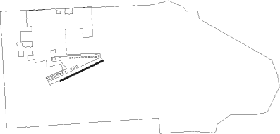
Runway info
| Runway 5 / 23 | ||
| length | 489m (1604ft) | |
| bearing | 75° / 255° | |
| width | 15m (50ft) | |
| surface | asphalt | |
| blast zone | 255m (837ft) / 255m (837ft) | |
Nearby beacons
| code | identifier | dist | bearing | frequency |
|---|---|---|---|---|
| YKM | YAKIMA VORTAC | 5.7 | 174° | 116 |
| ELN | ELLENSBURG (ELLENSBERG) VOR/DME | 21.4 | 359° | 117.90 |
| EAT | WENATCHEE VOR/DME | 45.1 | 18° | 111 |
| LTJ | KLICKITAT (THE DALLES) VOR/DME | 63.2 | 214° | 112.30 |
Disclaimer
The information on this website is not for real aviation. Use this data with the X-Plane flight simulator only! Data taken with kind consent from X-Plane 12 source code and data files. Content is subject to change without notice.