Findlay
Airport details
| Country | United States of America |
| State | Ohio |
| Region | K5 |
| Airspace | Cleveland Ctr |
| Municipality | Hancock County |
| Elevation | 812ft (247m) |
| Timezone | GMT -5 |
| Coordinates | 41.01203, -83.66861 |
| Magnetic var | |
| Type | land |
| Available since | X-Plane v10.40 |
| ICAO code | KFDY |
| IATA code | FDY |
| FAA code | FDY |
Communication
| Findlay ASOS | 132.850 |
| Findlay CTAF/UNICOM | 122.725 |
| Findlay Toledo Approach | 120.800 |
| Findlay TOLEDO Approach/Departure | 120.800 |
| Findlay Toledo Departure | 120.800 |
Nearby Points of Interest:
First Hancock County Courthouse
-Adams School
-Leipsic Village Hall
-John Edwards House
-Ada Pennsylvania Station and Railroad Park
-Col. Crawford Burn Site Monument
-Ottawa Waterworks Building
-Putnam County Courthouse
-Dr. H. Huber Block
-North Main-North Detroit Street Historic District
-Wood County Courthouse and Jail
-Michaels Farm
-Kenton Public Library
-Hardin County Courthouse
-Floral Hall
-Armstrong Farm
-Bagby-Hossler House
-Aigler Alumni Building
-The Octagon
-Lima Pennsylvania Railroad Passenger Depot
-Klaus Block
-Metropolitan Block
-Renz Block
-Allen County Courthouse
-Ohio Theatre
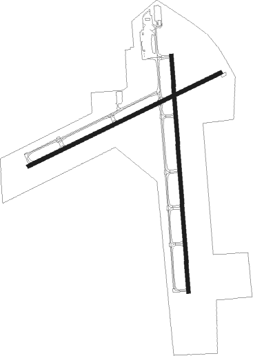
Runway info
Runway 18 / 36  | ||
| length | 1982m (6503ft) | |
| bearing | 180° / 0° | |
| width | 30m (100ft) | |
| surface | asphalt | |
| Runway 7 / 25 | ||
| length | 1790m (5873ft) | |
| bearing | 74° / 254° | |
| width | 30m (100ft) | |
| surface | asphalt | |
| displ threshold | 99m (325ft) / 305m (1001ft) | |
| blast zone | 0m (0ft) / 40m (131ft) | |
Nearby beacons
| code | identifier | dist | bearing | frequency |
|---|---|---|---|---|
| FBC | FLAG CITY VORTAC | 5.2 | 237° | 108.20 |
| TII | TIFFIN NDB | 21.1 | 80° | 269 |
| TO | TOPHR (TOLEDO) NDB | 34.4 | 335° | 219 |
| TOL | TOLEDO TACAN | 35.4 | 347° | 112.50 |
| BUD | BUCKEYE (MARION) VOR | 36.3 | 123° | 109.80 |
| ROD | ROSEWOOD VORTAC | 46.7 | 207° | 117.50 |
| PCW | PORT CLINTON NDB | 47.2 | 58° | 423 |
| ADG | ADRIAN NDB | 54.7 | 335° | 278 |
| OS | FULER (COLUMBUS) NDB | 60.3 | 153° | 515 |
| DQN | DAYTON VOR/DME | 68.4 | 216° | 114.50 |
Instrument approach procedures
| runway | airway (heading) | route (dist, bearing) |
|---|---|---|
| RW07 | JINAK (85°) | JINAK PURIC (16mi, 93°) 2500ft |
| RW07 | KINDE (35°) | KINDE PURIC (10mi, 337°) 2500ft |
| RW07 | PURIC (74°) | PURIC 2500ft |
| RNAV | PURIC 2500ft NOBIC (6mi, 73°) 2400ft KFDY (5mi, 75°) 834ft (5118mi, 116°) 1213ft DOYET (5108mi, 296°) 2500ft DOYET (turn) | |
| RW18 | DAZEY (210°) | DAZEY GAVEY (9mi, 241°) 2500ft |
| RW18 | GAVEY (181°) | GAVEY 2500ft |
| RW18 | ILLIE (117°) | ILLIE GAVEY (21mi, 95°) 2500ft |
| RNAV | GAVEY 2500ft MANSY (6mi, 180°) 2400ft CAKIS (2mi, 180°) 1640ft KFDY (3mi, 183°) 848ft (5118mi, 116°) 1063ft KASPE (5118mi, 296°) 2600ft KASPE (turn) | |
| RW25 | DAZEY (210°) | DAZEY DOYET (13mi, 161°) 2500ft |
| RW25 | DOYET (253°) | DOYET 2500ft |
| RW25 | DUSKY (282°) | DUSKY DOYET (15mi, 306°) 2500ft |
| RNAV | DOYET 2500ft EPEYE (6mi, 254°) 2500ft KFDY (5mi, 252°) 855ft (5118mi, 116°) 1116ft PURIC (5129mi, 296°) 2500ft PURIC (turn) | |
| RW36 | FBC (57°) | FBC KASPE (9mi, 148°) 3000ft KASPE (turn) 2600ft |
| RW36 | LAWTO (323°) | LAWTO KASPE (9mi, 283°) 2600ft |
| RW36 | ROD (27°) | ROD COSOP (21mi, 35°) 3000ft KASPE (15mi, 36°) 2600ft |
| RNAV | KASPE 2600ft FABKI (6mi, 0°) 2500ft KFDY (6mi, 359°) 850ft (5118mi, 116°) 1106ft GAVEY (5119mi, 296°) 2500ft GAVEY (turn) |
Disclaimer
The information on this website is not for real aviation. Use this data with the X-Plane flight simulator only! Data taken with kind consent from X-Plane 12 source code and data files. Content is subject to change without notice.