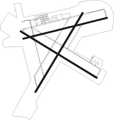
Fernandina Beach - Fernandina Beach Muni
Airport details
| Country | United States of America |
| State | Florida |
| Region | K7 |
| Airspace | Jacksonville Ctr |
| Municipality | Fernandina Beach |
| Elevation | 16ft (5m) |
| Timezone | GMT -5 |
| Coordinates | 30.61183, -81.46120 |
| Magnetic var | |
| Type | land |
| Available since | X-Plane v10.40 |
| ICAO code | KFHB |
| IATA code | n/a |
| FAA code | FHB |
Communication
| Fernandina Beach Muni AWOS-3 | 118.075 |
| Fernandina Beach Muni CTAF/UNICOM | 122.700 |
| Fernandina Beach Muni JACKSONVILLE Approach | 127.000 |
| Fernandina Beach Muni JACKSONVILLE Departure | 127.000 |
Runway info
Nearby beacons
| code | identifier | dist | bearing | frequency |
|---|---|---|---|---|
| NRB | MAYPORT TACAN | 13.5 | 170° | 111.40 |
| CRG | CRAIG (JACKSONVILLE) VORTAC | 16.5 | 190° | 114.50 |
| JA | DINNS (JACKSONVILLE) NDB | 19.6 | 247° | 344 |
| NIP | JACKSONVILLE TACAN | 25.2 | 210° | 108.20 |
| SSI | BRUNSWICK (ST SIMONS I) VORTAC | 26.3 | 2° | 109.80 |
| NZC | CECIL TACAN | 31.6 | 226° | 114.10 |
| SGJ | SAINT AUGUSTINE VOR/DME | 39.9 | 169° | 109.40 |
| RYD | REYNOLDS (GREEN COVE SPRINGS) NDB | 40 | 197° | 338 |
| AY | WIKET (WAYCROSS) NDB | 64.5 | 307° | 219 |
| GN | WYNDS (GAINESVILLE) NDB | 67.5 | 217° | 269 |
| GNV | GATORS VORTAC | 69.4 | 221° | 116.20 |
Instrument approach procedures
| runway | airway (heading) | route (dist, bearing) |
|---|---|---|
| RW04 | WILNA (39°) | WILNA 2100ft |
| RNAV | WILNA 2100ft SHOAT (7mi, 40°) 1800ft DENOO (3mi, 40°) 880ft KFHB (3mi, 39°) 59ft (4964mi, 111°) 265ft EZDAW (4958mi, 291°) 2000ft EZDAW (turn) | |
| RW13 | ACAPU (121°) | ACAPU 3000ft |
| RW13 | HUPAR (146°) | HUPAR ACAPU (6mi, 220°) 3000ft |
| RW13 | JOBUK (99°) | JOBUK ACAPU (6mi, 40°) 3000ft |
| RNAV | ACAPU 3000ft ZIGOL (6mi, 122°) 2000ft HIROP (3mi, 122°) 1080ft KFHB (4mi, 120°) 61ft (4964mi, 111°) 500ft ACAPU (4975mi, 291°) 3000ft ACAPU (turn) 3000ft | |
| RW22 | EZDAW (220°) | EZDAW 2000ft |
| RW22 | HEVIP (244°) | HEVIP EZDAW (6mi, 302°) 2000ft |
| RW22 | IFWOC (192°) | IFWOC EZDAW (6mi, 122°) 2000ft |
| RNAV | EZDAW 2000ft CUGTO (7mi, 220°) 2000ft FIVBA (3mi, 220°) 1080ft KFHB (3mi, 220°) 75ft (4964mi, 111°) 600ft EZDAW (4958mi, 291°) 2000ft EZDAW (turn) |
Disclaimer
The information on this website is not for real aviation. Use this data with the X-Plane flight simulator only! Data taken with kind consent from X-Plane 12 source code and data files. Content is subject to change without notice.

