Frankfort - Frankfort Muni
Airport details
| Country | United States of America |
| State | Indiana |
| Region | K5 |
| Airspace | Chicago Ctr |
| Municipality | Frankfort |
| Elevation | 859ft (262m) |
| Timezone | GMT -5 |
| Coordinates | 40.27343, -86.56217 |
| Magnetic var | |
| Type | land |
| Available since | X-Plane v10.40 |
| ICAO code | KFKR |
| IATA code | n/a |
| FAA code | FKR |
Communication
| Frankfort Muni AWOS 3 | 124.325 |
| Frankfort Muni CTAF/UNICOM | 123.000 |
Nearby Points of Interest:
South Frankfort Historic District
-Frankfort Commercial Historic District
-Clinton County Courthouse
-Charles H. and Emma Condon House
-Old Frankfort Stone High School
-Christian Ridge Historic District
-Colfax Carnegie Library
-Rosenberger Building
-Thorntown Public Library
-John Young House
-Kirklin Public Library
-William Fisher Polygonal Barn
-Lancaster Covered Bridge
-Hershey House
-Strange Nathanial Cragun House
-Boone County Courthouse
-Andrew B. VanHuys Round Barn
-Ely Homestead
-Linden Depot
-Scott Street Pavilion
-Waldron-Beck House and Carriage House
-St. Mary Historic District
-Ninth Street Hill Neighborhood Historic District
-Judge Cyrus Ball House
-James H. Ward House
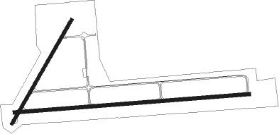
Runway info
Runway 9 / 27  | ||
| length | 1520m (4987ft) | |
| bearing | 90° / 270° | |
| width | 23m (75ft) | |
| surface | asphalt | |
| Runway 4 / 22 | ||
| length | 774m (2539ft) | |
| bearing | 42° / 222° | |
| width | 21m (70ft) | |
| surface | asphalt | |
Nearby beacons
| code | identifier | dist | bearing | frequency |
|---|---|---|---|---|
| CFJ | CRAWFORDSVILLE NDB | 23.9 | 230° | 388 |
| LA | EARLE (LAFAYETTE) NDB | 24.2 | 287° | 401 |
| OKK | KOKOMO VORTAC | 27.6 | 63° | 113.50 |
| BVT | BOILER (LAFAYETTE) VORTAC | 28.7 | 299° | 115.10 |
| VHP | BRICKYARD VORTAC | 28.9 | 157° | 116.30 |
| GUS | GRISSOM (PERU) VORTAC | 29.1 | 48° | 108.45 |
| UMP | METROPOLITAN (INDIANAPOLIS) NDB | 30.9 | 123° | 338 |
| FV | LAREZ (INDIANAPOLIS) NDB | 33.7 | 143° | 349 |
| CO | COLFA (INDIANAPOLIS) NDB | 40.8 | 149° | 232 |
| MZZ | MARION VOR/DME | 42.4 | 76° | 108.60 |
| DN | JULIP (DANVILLE) NDB | 44.3 | 271° | 332 |
| DNV | DANVILLE VORTAC | 45.6 | 271° | 111 |
| SHB | SHELBYVILLE VOR/DME | 51.3 | 131° | 112 |
| TTH | TERRE HAUTE VORTAC | 56.7 | 221° | 115.30 |
| HU | YINNO (TERRE HAUTE) NDB | 65.6 | 223° | 245 |
| BA | CLIFS (COLUMBUS) NDB | 66.6 | 142° | 410 |
Instrument approach procedures
| runway | airway (heading) | route (dist, bearing) |
|---|---|---|
| RW09 | BVT (119°) | BVT JOVIV (14mi, 123°) 2500ft HULOL (8mi, 180°) 2500ft |
| RW09 | HULOL (90°) | HULOL 2500ft |
| RW09 | JELLS (20°) | JELLS VAPBU (11mi, 306°) 2500ft HULOL (8mi, 360°) 2500ft |
| RNAV | HULOL 2500ft OSWAB (7mi, 90°) 2500ft ZITUD (3mi, 90°) 1680ft KFKR (3mi, 89°) 896ft (5248mi, 115°) 1106ft CAXEV (5235mi, 295°) 2500ft CAXEV (turn) | |
| RW27 | CAXEV (270°) | CAXEV 2500ft |
| RW27 | OKK (243°) | OKK WONPU (13mi, 242°) 2500ft CAXEV (8mi, 180°) 2500ft |
| RW27 | ZIPPY (319°) | ZIPPY JOXUD (10mi, 3°) 2500ft CAXEV (8mi, 0°) 2500ft |
| RNAV | CAXEV 2500ft OSJOG (7mi, 270°) 2500ft KFKR (6mi, 270°) 901ft (5248mi, 115°) 1111ft HULOL (5260mi, 295°) 2500ft HULOL (turn) |
Disclaimer
The information on this website is not for real aviation. Use this data with the X-Plane flight simulator only! Data taken with kind consent from X-Plane 12 source code and data files. Content is subject to change without notice.