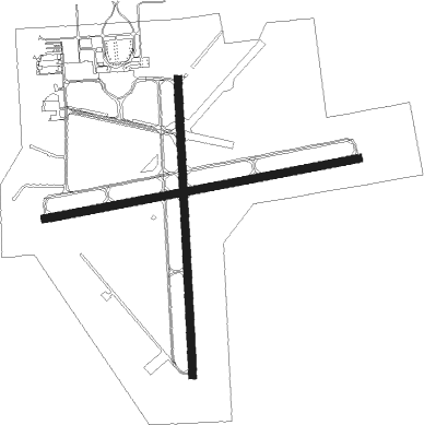
Florence - Florence Rgnl
Airport details
| Country | United States of America |
| State | South Carolina |
| Region | K7 |
| Airspace | Jacksonville Ctr |
| Municipality | Florence County |
| Elevation | 145ft (44m) |
| Timezone | GMT -5 |
| Coordinates | 34.18536, -79.72389 |
| Magnetic var | |
| Type | land |
| Available since | X-Plane v10.40 |
| ICAO code | KFLO |
| IATA code | FLO |
| FAA code | FLO |
Communication
| Florence Rgnl ATIS | 123.625 |
| Florence Rgnl CTAF | 125.100 |
| Florence Rgnl UNICOM | 122.950 |
| Florence Rgnl Ground Control/Clearance DEL | 121.900 |
| Florence Rgnl Tower | 125.100 |
| Florence Rgnl Approach Departure | 118.600 |
| Florence Rgnl Approach Departure | 135.250 |
Approach frequencies
| ILS-cat-I | RW09 | 109.1 | 18.00mi |
| 3° GS | RW09 | 109.1 | 18.00mi |
Nearby Points of Interest:
Florence Stockade
-Poynor School
-Florence Downtown Historic District
-Florence Public Library
-Bonnie Shade
-Red Doe
-Mt. Zion Rosenwald School
-Blooming Grove
-Roseville Plantation
-Claussen House
-Young Farm
-Edmund H. Deas House
-South Carolina Western Railway Station
-Wilds-Edwards House
-Clarence McCall House
-Manne Building
-Darlington Downtown Historic District
-Cashua Street-Spring Street Historic District
-Charles S. McCullough House
-Julius A. Dargan House
-Mrs. B.F. Williamson House
-John Hayes Farmstead
-Marion High School
-McMillan House (Latta, South Carolina)
-Dillon Downtown Historic District
Nearby beacons
| code | identifier | dist | bearing | frequency |
|---|---|---|---|---|
| FLO | FLORENCE VORTAC | 4.3 | 54° | 115.20 |
| FL | ALCOT (FLORENCE) NDB | 6.4 | 265° | 335 |
| UDG | DARLINGTON NDB | 17.4 | 328° | 245 |
| CFY | EVANS (LAKE CITY) NDB | 19.9 | 187° | 420 |
| DLC | DILLON NDB | 23.7 | 53° | 274 |
| HVS | HARTSVILLE NDB | 23.7 | 299° | 341 |
| BES | BENNETTSVILLE NDB | 26.1 | 359° | 230 |
| SMS | SUMTER NDB | 33.7 | 253° | 252 |
| ME | MAXTN (MAXTON) NDB | 35.7 | 27° | 257 |
| JB | JIGEL (LUMBERTON) NDB | 36.2 | 58° | 384 |
| HYW | HORRY (CONWAY) NDB | 36.7 | 121° | 370 |
| SSC | SHAW (SUMTER) TACAN | 38.9 | 254° | 110.10 |
| CTF | CHESTERFIELD VOR/DME | 39 | 310° | 108.20 |
| MNI | MANNING NDB | 43.1 | 219° | 381 |
| PHH | ANDREWS NDB | 45.1 | 165° | 255 |
| CRE | GRAND STRAND VORTAC | 54.5 | 110° | 114.40 |
| VAN | VANCE VORTAC | 55.9 | 226° | 110.40 |
| FAY | FAYETTEVILLE VOR/DME | 63.8 | 47° | 108.80 |
| POB | POPE (FAYETTEVILLE) TACAN | 68.5 | 36° | 113.80 |
| FGP | FORT BRAGG NDB | 72.8 | 44° | 393 |
Instrument approach procedures
| runway | airway (heading) | route (dist, bearing) |
|---|---|---|
| RW01 | CLETA (284°) | CLETA EBPAM (16mi, 255°) 2500ft NUTAL (5mi, 269°) 2000ft |
| RW01 | NUTAL (0°) | NUTAL 2000ft |
| RW01 | PEGIE (44°) | PEGIE NUTAL (11mi, 81°) 2000ft |
| RNAV | NUTAL 2000ft PAILS (6mi, 359°) 1700ft KFLO (5mi, 2°) 169ft TNPIN (11mi, 2°) 2000ft TNPIN (turn) | |
| RW09 | CHART (78°) | CHART CADZU (14mi, 72°) 3000ft |
| RW09 | FLO (234°) | FLO CADZU (16mi, 258°) 3000ft CADZU (turn) 3000ft |
| RW09 | PEGIE (44°) | PEGIE GOBAC (7mi, 348°) 3000ft CADZU (5mi, 352°) 3000ft |
| RW09 | WARNR (135°) | WARNR OXBIP (14mi, 175°) 3000ft CADZU (5mi, 172°) 3000ft |
| RNAV | CADZU 3000ft IMOVE (6mi, 85°) 2200ft GOCEL (3mi, 85°) 1180ft KFLO (4mi, 85°) 206ft (4896mi, 113°) 441ft ESVAC (4885mi, 293°) 2000ft ESVAC (turn) | |
| RW19 | CARLI (260°) | CARLI RINCE (15mi, 292°) 2000ft TNPIN (5mi, 271°) 2000ft |
| RW19 | COPEL (144°) | COPEL TNPIN (7mi, 89°) 2000ft |
| RW19 | DUNGY (194°) | DUNGY TNPIN (10mi, 208°) 2000ft |
| RW19 | TNPIN (182°) | TNPIN 2000ft |
| RNAV | TNPIN 2000ft FRACK (6mi, 182°) 1700ft HOBEN (3mi, 182°) 840ft KFLO (3mi, 181°) 185ft PAILS (5mi, 182°) NUTAL (6mi, 179°) 2000ft NUTAL (turn) | |
| RW27 | CARLI (260°) | CARLI ESVAC (9mi, 253°) 2000ft |
| RW27 | CLETA (284°) | CLETA ESVAC (12mi, 304°) 2000ft |
| RW27 | FLO (234°) | FLO ESVAC (8mi, 100°) 2000ft ESVAC (turn) 2000ft |
| RNAV | ESVAC 2000ft MENGY (6mi, 265°) 1600ft KFLO (5mi, 264°) 168ft (4896mi, 113°) 474ft IMOVE (4902mi, 293°) 2000ft IMOVE (turn) |
Disclaimer
The information on this website is not for real aviation. Use this data with the X-Plane flight simulator only! Data taken with kind consent from X-Plane 12 source code and data files. Content is subject to change without notice.

