Black Forest - Meadow Lake
Airport details
| Country | United States of America |
| State | Colorado |
| Region | K2 |
| Airspace | Denver Ctr |
| Municipality | El Paso County |
| Elevation | 6874ft (2095m) |
| Timezone | GMT -7 |
| Coordinates | 38.94575, -104.56989 |
| Magnetic var | |
| Type | land |
| Available since | X-Plane v10.40 |
| ICAO code | KFLY |
| IATA code | n/a |
| FAA code | n/a |
Communication
| Meadow Lake CTAF/UNICOM | 122.700 |
Nearby Points of Interest:
Black Squirrel Creek Bridge
-Black Forest School
-Taylor Memorial Chapel
-J.G. Evans Barn
-Cottonwood Creek Bridge
-Drennan School
-Lennox House
-Edgeplain
-Fort Collins Municipal Railway No. 22
-Ida M. Rice House
-Burgess House
-Santa Fe Depot
-Montgomery Hall, Colorado College
-Bemis Hall
-Frederick H. Cossitt Memorial Hall
-S. A. Wilson Elementary School
-Gwynne–Love House
-Hagerman Mansion
-Judson Moss Bemis House
-United States Post Office and Federal Courthouse-Colorado Springs Main
-DeGraff Building
-Emmanuel Presbyterian Church
-Colorado Springs Public Library-Carnegie Building
-D&RGW 168
-Calhan Rock Island Railroad Depot
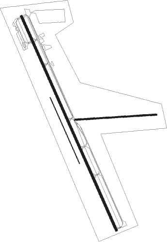
Runway info
Runway 15 / 33  | ||
| length | 1831m (6007ft) | |
| bearing | 156° / 336° | |
| width | 18m (60ft) | |
| surface | asphalt | |
| Runway 08 / 26 | ||
| length | 636m (2087ft) | |
| bearing | 91° / 271° | |
| width | 11m (35ft) | |
| surface | dirt | |
| Runway 16 / 34 | ||
| length | 563m (1847ft) | |
| bearing | 156° / 336° | |
| width | 5m (15ft) | |
| surface | grass | |
Nearby beacons
| code | identifier | dist | bearing | frequency |
|---|---|---|---|---|
| BRK | BLACK FOREST VOR/DME | 2.9 | 269° | 112.50 |
| CO | PETEY (COLORADO SPRINGS) NDB | 16.5 | 210° | 407 |
| FCS | BUTTS (FORT CARSON) VOR/DME | 18.1 | 215° | 108.80 |
| IHS | IRONHORSE (FORT CARSON) NDB | 18.1 | 214° | 335 |
| PUB | PUEBLO VORTAC | 39.6 | 168° | 116.70 |
| TF | ARUBA (PUEBLO) NDB | 40.6 | 162° | 373 |
| FQF | FALCON (DENVER) VORTAC | 44.7 | 356° | 116.30 |
| HGO | HUGO VOR/DME | 45 | 98° | 112.10 |
| BKF | BUCKLEY (AURORA) TACAN | 46.5 | 347° | 109.60 |
| DEN | DENVER VOR/DME | 52.2 | 354° | 117.90 |
| DVV | MILE HIGH (DENVER) VORTAC | 57 | 357° | 114.70 |
| BJC | JEFFCO (DENVER) VOR/DME | 63.8 | 330° | 115.40 |
Disclaimer
The information on this website is not for real aviation. Use this data with the X-Plane flight simulator only! Data taken with kind consent from X-Plane 12 source code and data files. Content is subject to change without notice.