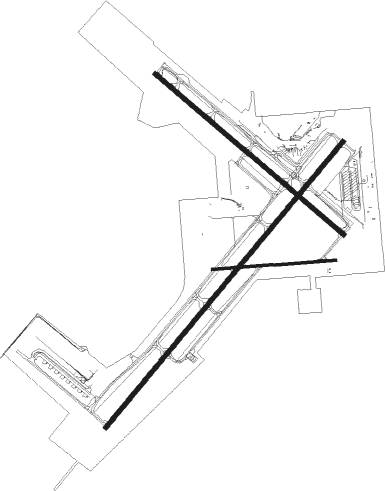
Fort Wayne - Ft Wayne Intl
Airport details
| Country | United States of America |
| State | Indiana |
| Region | K5 |
| Airspace | Chicago Ctr |
| Municipality | Fort Wayne |
| Elevation | 812ft (247m) |
| Timezone | GMT -5 |
| Coordinates | 40.97847, -85.19517 |
| Magnetic var | |
| Type | land |
| Available since | X-Plane v10.40 |
| ICAO code | KFWA |
| IATA code | FWA |
| FAA code | FWA |
Communication
| Ft Wayne Intl ATIS | 121.250 |
| Ft Wayne Intl UNICOM | 122.950 |
| Ft Wayne Intl Clearance DEL | 124.750 |
| Ft Wayne Intl Ground Control | 121.900 |
| Ft Wayne Intl Tower | 119.100 |
| Ft Wayne Intl FORT WAYNE ApproachROACH | 132.150 |
| Ft Wayne Intl FORT WAYNE ApproachROACH | 135.325 |
| Ft Wayne Intl FORT WAYNE DepartureARTURE | 127.200 |
Approach frequencies
| ILS-cat-II | RW05 | 111.9 | 18.00mi |
| ILS-cat-I | RW32 | 109.9 | 18.00mi |
| 3° GS | RW32 | 109.9 | 18.00mi |
| 3° GS | RW05 | 111.9 | 18.00mi |
Nearby Points of Interest:
Horney Robinson House
-Foster Park Neighborhood Historic District
-Illsley Place-West Rudisill Historic District
-Lafayette Place Historic District
-Oakdale Historic District
-South Wayne Historic District
-Robert M. Feustel House
-John D. Haynes House
-Wildwood Park Historic District
-Williams-Woodland Park Historic District
-Fairfield Manor
-Harry A. Keplinger House
-Vermilyea Inn Historic District
-Thomas W. Swinney House
-St. Peter's Square
-West End Historic District
-John Claus Peters House
-E. Ross Adair Federal Building and United States Courthouse
-Masonic Temple
-Blackstone Building
-Trinity Episcopal Church
-Fort Wayne Printing Company Building
-Schmitz Block
-Louis Mohr Block
-Kresge-Groth Building
Runway info
Nearby beacons
| code | identifier | dist | bearing | frequency |
|---|---|---|---|---|
| FWA | FORT WAYNE VORTAC | 0.3 | 85° | 117.80 |
| OLK | WEBSTER LAKE VOR | 21.1 | 312° | 110.40 |
| GW | SHENK (AUBURN) NDB | 22.8 | 37° | 227 |
| MZZ | MARION VOR/DME | 36.5 | 225° | 108.60 |
| MIE | MUNCIE VOR/DME | 45.4 | 195° | 114.40 |
| OKK | KOKOMO VORTAC | 47.6 | 242° | 113.50 |
| GUS | GRISSOM (PERU) VORTAC | 47.8 | 251° | 108.45 |
| JN | BALLL (MUNCIE) NDB | 48.2 | 189° | 365 |
| MI | BALLL (MUNCIE) NDB | 48.2 | 189° | 365 |
| GSH | GOSHEN VORTAC | 49.9 | 303° | 113.70 |
| AWW | WINCHESTER NDB | 50.2 | 161° | 212 |
| IRS | STURGIS NDB | 51.2 | 344° | 382 |
| AI | VIDEO (ANDERSON) NDB | 56.4 | 199° | 394 |
| DQN | DAYTON VOR/DME | 68.3 | 140° | 114.50 |
Instrument approach procedures
| runway | airway (heading) | route (dist, bearing) |
|---|---|---|
| RW05 | FWA (265°) | FWA EBACO (13mi, 233°) 3000ft EBACO (turn) 3000ft |
| RNAV | EBACO 3000ft ZANOX (6mi, 52°) 2500ft KFWA (6mi, 51°) 870ft (5187mi, 116°) 1065ft SLYDR (5180mi, 296°) 3000ft SLYDR (turn) | |
| RW14 | FWA (265°) | FWA LABIC (12mi, 307°) 3000ft LABIC (turn) 3000ft |
| RNAV | LABIC 3000ft MUPUE (6mi, 127°) 2500ft KFWA (6mi, 130°) 855ft (5187mi, 116°) 1002ft CABAC (5179mi, 296°) 3000ft CABAC (turn) | |
| RW23 | FWA (265°) | FWA SLYDR (11mi, 52°) 3000ft SLYDR (turn) 3000ft |
| RW23 | GRABI (227°) | GRABI SLYDR (10mi, 219°) 3000ft |
| RNAV | SLYDR 3000ft AKEWS (6mi, 232°) 2300ft BABAC (2mi, 232°) 1520ft KFWA (3mi, 234°) 854ft (5187mi, 116°) 1053ft EBACO (5195mi, 296°) 3000ft EBACO (turn) | |
| RW32 | FWA (265°) | FWA CABAC (11mi, 126°) 3000ft CABAC (turn) 3000ft |
| RNAV | CABAC 3000ft DABYA (6mi, 307°) 2300ft KFWA (5mi, 303°) 852ft (5187mi, 116°) 1000ft LABIC (5196mi, 296°) 3000ft LABIC (turn) |
Disclaimer
The information on this website is not for real aviation. Use this data with the X-Plane flight simulator only! Data taken with kind consent from X-Plane 12 source code and data files. Content is subject to change without notice.

