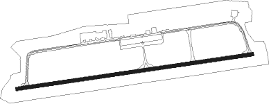
West Point - Middle Peninsula Regl
Airport details
| Country | United States of America |
| State | Virginia |
| Region | K6 |
| Airspace | Washington Ctr |
| Municipality | King and Queen County |
| Elevation | 20ft (6m) |
| Timezone | GMT -5 |
| Coordinates | 37.52133, -76.76275 |
| Magnetic var | |
| Type | land |
| Available since | X-Plane v10.40 |
| ICAO code | KFYJ |
| IATA code | n/a |
| FAA code | FYJ |
Communication
| Middle Peninsula Regl AWOS 3 | 132.825 |
| Middle Peninsula Regl CTAF/UNICOM | 123.000 |
| Middle Peninsula Regl POTOMAC Approach/Departure | 126.400 |
| Middle Peninsula Regl POTOMAC Approach/Departure | 126.750 |
Approach frequencies
| LOC | RW10 | 109.55 | 18.00mi |
Nearby beacons
| code | identifier | dist | bearing | frequency |
|---|---|---|---|---|
| HCM | HARCUM VORTAC | 5 | 145° | 108.80 |
| HPW | HOPEWELL VORTAC | 20.4 | 241° | 112 |
| RIC | RICHMOND VORTAC | 26.5 | 268° | 114.10 |
| LFI | LANGLEY (HAMPTON) TACAN | 32.4 | 137° | 112.30 |
| AKQ | WAKEFIELD NDB | 34.2 | 204° | 274 |
| CCV | CAPE CHARLES VORTAC | 37.9 | 103° | 112.20 |
| NGU | CHAMBERS (NORFOLK) TACAN | 41.9 | 140° | 113.95 |
| ORF | NORFOLK VORTAC | 46.3 | 138° | 116.90 |
| OR | INGLE (NORFOLK) NDB | 47.6 | 143° | 329 |
| NHK | NAS PATUXENT RIVER TACAN | 48.5 | 25° | 110.25 |
| NHK | PATUXENT NDB | 48.9 | 25° | 400 |
| PXT | PATUXENT (PATUXENT RIVER) VORTAC | 49.1 | 25° | 117.60 |
| FKN | FRANKLIN VORTAC | 49.9 | 197° | 110.60 |
| NTU | OCEANA TACAN | 54.3 | 134° | 116.60 |
| EZF | SHANNON (FREDERICKSBURG) NDB | 55.3 | 317° | 237 |
| BRV | BROOKE VORTAC | 56.3 | 324° | 114.50 |
| NFE | CHESAPEAKE TACAN | 57.8 | 143° | 108.25 |
Instrument approach procedures
| runway | airway (heading) | route (dist, bearing) |
|---|---|---|
| RW10 | HPW (61°) | HPW ICACO (11mi, 23°) 2000ft |
| RW10 | ICACO (87°) | ICACO 2000ft |
| RNAV | ICACO 2000ft KULEY (8mi, 87°) 1700ft GORYE (3mi, 87°) 660ft KFYJ (2mi, 87°) 58ft (4777mi, 116°) 264ft CIBAC (4774mi, 296°) JUDLU (8mi, 130°) 2000ft JUDLU (turn) | |
| RWNVB | CORET (230°) | CORET ZINAV (12mi, 175°) 2000ft |
| RWNVB | STEIN (262°) | STEIN ZINAV (9mi, 254°) 2000ft |
| RWNVB | ZINAV (267°) | ZINAV 2000ft |
| RNAV | ZINAV 2000ft JUGPI (7mi, 267°) 2000ft YINDU (3mi, 267°) 740ft KFYJ (2mi, 267°) 73ft (4777mi, 116°) 420ft ICACO (4790mi, 296°) 2000ft ICACO (turn) |
Disclaimer
The information on this website is not for real aviation. Use this data with the X-Plane flight simulator only! Data taken with kind consent from X-Plane 12 source code and data files. Content is subject to change without notice.
