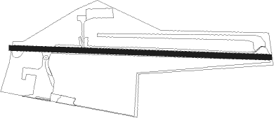
Great Barrington - Walter J Koladza
Airport details
| Country | United States of America |
| State | Massachusetts |
| Region | K6 |
| Airspace | Boston Ctr |
| Municipality | Great Barrington |
| Elevation | 736ft (224m) |
| Timezone | GMT -5 |
| Coordinates | 42.18422, -73.40324 |
| Magnetic var | |
| Type | land |
| Available since | X-Plane v10.40 |
| ICAO code | KGBR |
| IATA code | GBR |
| FAA code | GBR |
Communication
| WALTER J KOLADZA CTAF/UNICOM | 122.800 |
| WALTER J KOLADZA ALBANY Approach/Departure | 125.000 |
Nearby Points of Interest:
Taconic and West Avenues Historic District
-Dwight-Henderson House
-Wheeler Family Farmstead
-United States Post Office–Great Barrington Main
-Westover-Bacon-Potts Farm
-Columbia Turnpike-East Tollhouse
-Monument Mills
-Housatonic Congregational Church
-Ramsdell Public Library
-Benjamin Osborn House
-Sheffield Center Historic District
-Hillsdale Hamlet Historic District
-North Hillsdale Methodist Church
-Glendale Power House
-Copake Iron Works Historic District
-North Chatham Historic District
-Church of St. John in the Wilderness
-Villa Virginia
-Main Street Historic District
-Elm-Maple-South Streets Historic District
-Mission House
-Stockbridge Casino
-Merrell Tavern
-Colonel John Ashley House
-Rock Ridge
Nearby beacons
| code | identifier | dist | bearing | frequency |
|---|---|---|---|---|
| PFH | PHILMONT (HUDSON) NDB | 14.8 | 282° | 272 |
| CTR | CHESTER VOR/DME | 21.1 | 77° | 115.10 |
| PWL | PAWLING (POUGHKEEPSIE) VOR/DME | 26.4 | 205° | 114.30 |
| BAF | BARNES (WESTFIELD/SPRINGF VORTAC | 30.6 | 92° | 113 |
| IGN | KINGSTON VOR/DME | 36.3 | 219° | 117.60 |
| ALB | ALBANY VORTAC | 38.1 | 325° | 115.30 |
| CEF | WESTOVER(SPRINGFIELD/CHIC TACAN | 39 | 89° | 114 |
| AL | HAWKY (ALBANY) NDB | 42 | 327° | 219 |
| HEU | HUNTER (SCHENECTADY) NDB | 46.5 | 322° | 356 |
| CAM | CAMBRIDGE VOR/DME | 48.7 | 4° | 115 |
| SKU | STANWYCK (NEWBURGH) NDB | 48.7 | 224° | 261 |
| HFD | HARTFORD VOR/DME | 50.2 | 122° | 114.90 |
| CMK | CARMEL VOR/DME | 54.8 | 191° | 116.60 |
| SW | NEELY (NEWBURGH) NDB | 55.8 | 230° | 335 |
| HVN | HAVEN DME | 60 | 151° | 109.80 |
| MAD | MADISON VOR/DME | 61.2 | 141° | 110.40 |
| JJH | JOHNSTOWN NDB | 63.8 | 311° | 523 |
Instrument approach procedures
| runway | airway (heading) | route (dist, bearing) |
|---|---|---|
| RW11 | BOWAN (57°) | BOWAN PIHIV (9mi, 304°) 4000ft PIHIV (turn) 4000ft |
| RW11 | CIRRU (137°) | CIRRU COGUD (9mi, 165°) 4000ft PIHIV (9mi, 188°) 4000ft |
| RW11 | WIGAN (76°) | WIGAN PIHIV (10mi, 49°) 4000ft |
| RNAV | PIHIV 4000ft ZACCO (7mi, 95°) 2500ft KGBR (6mi, 95°) 779ft (4671mi, 120°) 1139ft PIHIV (4683mi, 300°) 4000ft PIHIV (turn) | |
| RWNVB | PWL (25°) | PWL NIVIC (13mi, 52°) 4000ft INOPE (7mi, 68°) 4000ft HUMEP (6mi, 325°) 3000ft |
| RWNVB | STELA (249°) | STELA LUCIB (15mi, 173°) 4000ft INOPE (7mi, 248°) 4000ft HUMEP (6mi, 325°) 3000ft |
| RNAV | HUMEP 3000ft DUYPA (2mi, 325°) 2500ft ATRLO (5mi, 324°) 1500ft PIHIV (12mi, 275°) 4000ft PIHIV (turn) |
Disclaimer
The information on this website is not for real aviation. Use this data with the X-Plane flight simulator only! Data taken with kind consent from X-Plane 12 source code and data files. Content is subject to change without notice.
