Grand Forks - Grand Forks Intl
Airport details
| Country | United States of America |
| State | North Dakota |
| Region | K3 |
| Airspace | Minneapolis Ctr |
| Municipality | Grand Forks |
| Elevation | 845ft (258m) |
| Timezone | GMT -6 |
| Coordinates | 47.94728, -97.17377 |
| Magnetic var | |
| Type | land |
| Available since | X-Plane v10.40 |
| ICAO code | KGFK |
| IATA code | GFK |
| FAA code | GFK |
Communication
| Grand Forks Intl ATIS | 119.400 |
| Grand Forks Intl Clearance | 135.725 |
| Grand Forks Intl Grand Forks Ground | 124.575 |
| Grand Forks Intl Grand Forks Tower | 118.400 |
| Grand Forks Intl Grand Forks Approach | 118.100 |
| Grand Forks Intl Departure | 118.100 |
Approach frequencies
| ILS-cat-I | RW35L | 109.1 | 18.00mi |
| 2.7° GS | RW35L | 109.1 | 18.00mi |
Nearby Points of Interest:
Oxford House
-University of North Dakota Historic District
-North Dakota Mill and Elevator
-The Kegs Drive-In
-Grand Forks Riverside Neighborhood Historic District
-St. Michael's Hospital and Nurses' Residence
-St. Michael's Church
-Washington School
-Skarsbo Apartments
-Lyons Garage
-Grand Forks City Hall
-Northern Pacific Depot and Freight House
-Grand Forks Mercantile Building 1898
-Grand Forks Mercantile Co.
-Ronald N. Davies Federal Building and U.S. Courthouse
-New Hampshire Apartments
-Telephone Co. Building
-Finks and Gokey Block
-Wright Block
-Iddings Block
-Roller Office Supply
-First National Bank
-St. John's Block Commercial Exchange
-Stratford Building
-Dakota Block
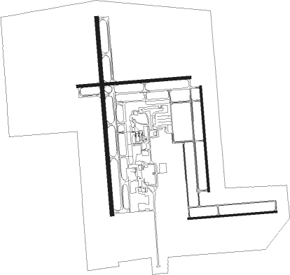
Runway info
Runway 9R / 27L  | ||
| length | 1003m (3291ft) | |
| bearing | 90° / 270° | |
| width | 18m (60ft) | |
| surface | concrete | |
| Runway 17R / 35L | ||
| length | 2242m (7356ft) | |
| bearing | 180° / 0° | |
| width | 46m (150ft) | |
| surface | asphalt | |
| blast zone | 64m (210ft) / 57m (187ft) | |
| Runway 17L / 35R | ||
| length | 1190m (3904ft) | |
| bearing | 180° / 0° | |
| width | 23m (75ft) | |
| surface | concrete | |
| Runway 9L / 27R | ||
| length | 1279m (4196ft) | |
| bearing | 90° / 270° | |
| width | 30m (100ft) | |
| surface | concrete | |
Nearby beacons
| code | identifier | dist | bearing | frequency |
|---|---|---|---|---|
| GFK | GRAND FORKS VOR/DME | 0.6 | 303° | 114.30 |
| GF | HISER NDB | 6 | 184° | 345 |
| RDR | RED RIVER (GRAND FORKS) TACAN | 9.3 | 272° | 116.40 |
| TVF | THIEF RIVER FALLS VOR/DME | 40.3 | 83° | 114.45 |
| HML | HUMBOLDT TACAN | 55.4 | 3° | 112.40 |
| AA | KENIE (FARGO) NDB | 58.1 | 159° | 365 |
Instrument approach procedures
| runway | airway (heading) | route (dist, bearing) |
|---|---|---|
| RW09L | BISCA (96°) | BISCA DUCEV (6mi, 108°) 4000ft |
| RW09L | GFK (123°) | GFK DUCEV (11mi, 269°) 4000ft DUCEV (turn) 4000ft |
| RW09L | UNIZY (57°) | UNIZY DUCEV (28mi, 39°) 4000ft |
| RNAV | DUCEV 4000ft ARIDE (6mi, 90°) 2500ft BALEE (3mi, 90°) 1400ft KGFK (2mi, 95°) 880ft (5693mi, 116°) 1093ft URBAH (5682mi, 296°) 2800ft URBAH (turn) | |
| RW17R | EYWUS (236°) | EYWUS WIXAG (5mi, 278°) 2600ft FODIB (7mi, 270°) 2600ft |
| RW17R | GFK (123°) | GFK FODIB (12mi, 1°) 2600ft FODIB (turn) 2600ft |
| RW17R | WUTSO (182°) | WUTSO FODIB (6mi, 190°) 2600ft |
| RNAV | FODIB 2600ft RULLO (7mi, 180°) 2500ft KGFK (6mi, 176°) 896ft (5693mi, 116°) 1043ft ERIXE (5695mi, 296°) 2600ft ERIXE (turn) | |
| RW27R | EYWUS (236°) | EYWUS URBAH (11mi, 180°) 2800ft |
| RW27R | GFK (123°) | GFK URBAH (12mi, 91°) 2800ft URBAH (turn) 2800ft |
| RW27R | JIXIR (295°) | JIXIR URBAH (8mi, 0°) 2800ft |
| RNAV | URBAH 2800ft JMKNG (6mi, 270°) 2400ft KGFK (5mi, 268°) 891ft (5693mi, 116°) 1093ft DUCEV (5705mi, 296°) 4000ft DUCEV (turn) 4000ft | |
| RW35L | GFK (123°) | GFK ERIXE (12mi, 179°) 2600ft ERIXE (turn) 2600ft |
| RW35L | SHELS (322°) | SHELS JOCOR (17mi, 301°) 2600ft ERIXE (8mi, 324°) 2600ft |
| RW35L | UNIZY (57°) | UNIZY IGIME (24mi, 67°) 3000ft ERIXE (5mi, 90°) 2600ft |
| RNAV | ERIXE 2600ft JAGBI (6mi, 0°) 2600ft KGFK (6mi, 4°) 900ft (5693mi, 116°) 1095ft FODIB (5692mi, 296°) 2600ft FODIB (turn) |
Disclaimer
The information on this website is not for real aviation. Use this data with the X-Plane flight simulator only! Data taken with kind consent from X-Plane 12 source code and data files. Content is subject to change without notice.