Grinnell - Grinnell Rgnl
Airport details
| Country | United States of America |
| State | Iowa |
| Region | K3 |
| Airspace | Chicago Ctr |
| Municipality | Grinnell |
| Elevation | 1004ft (306m) |
| Timezone | GMT -6 |
| Coordinates | 41.70989, -92.73597 |
| Magnetic var | |
| Type | land |
| Available since | X-Plane v10.40 |
| ICAO code | KGGI |
| IATA code | n/a |
| FAA code | GGI |
Communication
| Grinnell Rgnl CTAF/UNICOM | 122.800 |
| Grinnell Rgnl CHICAGO CNTR | 127.050 |
Nearby Points of Interest:
Chicago, Rock Island and Pacific Railroad-Grinnell Passenger Station
-Spaulding Manufacturing Company
-Bowers and McDonald Office Building
-Pioneer Oil Company Filling Station
-Stewart Library
-E.A. and Rebecca (Johnson) Marsh House
-Grinnell Herald Building
-Farmers Mutual Reinsurance Company Building
-Interior Telephone Company Building
-Levi P. Grinnell House
-Christian Science Society
-Goodnow Hall
-Mears Cottage
-B.J. Ricker House
-Poweshiek County Courthouse
-Montezuma Downtown Historic District
-Thomas Arthur House
-Jasper County Courthouse
-Lincoln Highway Bridge
-Tama County Jail
-Tama County Courthouse
-Thomas F. and Nancy Tuttle House
-Philipus J. and Cornelia Koelman House
-Dirk and Cornelia J. Vander Wilt Cottage
-Dominie Henry P. Scholte House
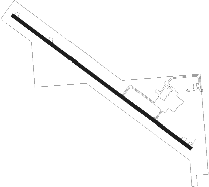
Runway info
| Runway 13 / 31 | ||
| length | 1584m (5197ft) | |
| bearing | 123° / 303° | |
| width | 23m (75ft) | |
| surface | concrete | |
| displ threshold | 65m (213ft) / 64m (210ft) | |
Nearby beacons
| code | identifier | dist | bearing | frequency |
|---|---|---|---|---|
| TNU | NEWTON VOR/DME | 17.2 | 281° | 112.50 |
| PEA | PELLA NDB | 20.5 | 214° | 257 |
| JWJ | ELMWOOD (MARSHALTOWN) VOR/DME | 25.3 | 337° | 109.40 |
| CID | CEDAR RAPIDS VOR/DME | 43.8 | 79° | 114.10 |
| DSM | DES MOINES VORTAC | 44.1 | 253° | 117.50 |
| OTM | OTTUMWA VOR/DME | 44.8 | 149° | 111.60 |
| ALO | WATERLOO VOR/DME | 53 | 22° | 112.20 |
| IIB | WAPSIE (INDEPENDENCE) NDB | 56.7 | 47° | 206 |
| BEX | BLOOMFIELD NDB | 59.5 | 162° | 269 |
Instrument approach procedures
| runway | airway (heading) | route (dist, bearing) |
|---|---|---|
| RW13 | BAXKO (123°) | BAXKO 3000ft |
| RW13 | BEIGE (255°) | BEIGE CIRYI (30mi, 274°) 3000ft BAXKO (5mi, 229°) 3000ft |
| RW13 | SINGR (44°) | SINGR DEFSA (18mi, 353°) 3000ft BAXKO (5mi, 49°) 3000ft |
| RNAV | BAXKO 3000ft APADY (6mi, 123°) 2700ft KGGI (6mi, 123°) 1024ft PICRA (12mi, 123°) 3000ft PICRA (turn) | |
| RW31 | GUERN (274°) | GUERN PICRA (15mi, 253°) 3000ft |
| RW31 | NASAL (337°) | NASAL PICRA (8mi, 44°) 3000ft |
| RW31 | PICRA (303°) | PICRA |
| RNAV | PICRA 3000ft IMOGE (6mi, 303°) 2600ft KGGI (5mi, 303°) 1048ft BAXKO (12mi, 303°) 3000ft BAXKO (turn) |
Disclaimer
The information on this website is not for real aviation. Use this data with the X-Plane flight simulator only! Data taken with kind consent from X-Plane 12 source code and data files. Content is subject to change without notice.