Greenville - Greenville Downtown
Airport details
| Country | United States of America |
| State | South Carolina |
| Region | K7 |
| Airspace | Atlanta Ctr |
| Municipality | Greenville |
| Elevation | 1044ft (318m) |
| Timezone | GMT -4 |
| Coordinates | 34.85056, -82.34982 |
| Magnetic var | |
| Type | land |
| Available since | X-Plane v10.40 |
| ICAO code | KGMU |
| IATA code | GMU |
| FAA code | GMU |
Communication
| Greenville Downtown ATIS | 127.075 |
| Greenville Downtown UNICOM | 122.950 |
| Greenville Downtown Ground Control | 121.250 |
| Greenville Downtown Tower | 119.900 |
| Greenville Downtown GREER Approach/Departure | 118.800 |
Approach frequencies
| ILS-cat-I | RW01 | 109.7 | 18.00mi |
| 3° GS | RW01 | 109.7 | 18.00mi |
Nearby Points of Interest:
Fountain Fox Beattie House
-East Park Historic District
-C.F. Haynsworth Federal Building and United States Courthouse
-Gilfillin and Houston Building
-Broad Margin
-American Cigar Factory
-Working Benevolent Temple and Professional Building
-Stradley and Barr Dry Goods Store
-Chamber of Commerce Building
-Greenville County Courthouse
-Old Greenville City Hall
-T.Q. Donaldson House
-Carolina Supply Company
-Hugh Aiken House
-Reedy River Industrial District
-Wyche Pavilion
-Whitehall
-West End Commercial Historic District
-C. Granville Wyche House
-Earle Town House
-First National Bank
-Parker High School Auditorium
-Mills Mill
-Monaghan Mill
-Southern Bleachery and Print Works
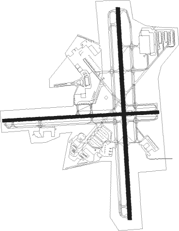
Runway info
Runway 1 / 19  | ||
| length | 1648m (5407ft) | |
| bearing | 1° / 181° | |
| width | 30m (100ft) | |
| surface | asphalt | |
| blast zone | 0m (0ft) / 61m (200ft) | |
| Runway 10 / 28 | ||
| length | 1216m (3990ft) | |
| bearing | 91° / 271° | |
| width | 24m (80ft) | |
| surface | asphalt | |
| displ threshold | 81m (266ft) / 82m (269ft) | |
Nearby beacons
| code | identifier | dist | bearing | frequency |
|---|---|---|---|---|
| GM | JUDKY (GREENVILLE) NDB | 4.2 | 180° | 521 |
| GY | DYANA (GREENVILLE) NDB | 10.6 | 210° | 338 |
| SPA | SPARTANBURG VORTAC | 23.5 | 67° | 115.70 |
| BRA | BROAD RIVER (ASHEVILLE) NDB | 26 | 344° | 379 |
| ELW | ELECTRIC CITY (ANDERSON) VORTAC | 33.6 | 225° | 108.60 |
| SUG | SUGARLOAF MT. (ASHEVILLE) VORTAC | 33.6 | 8° | 112.20 |
| UOT | UNION COUNTY NDB | 36.3 | 103° | 326 |
| GRD | GREENWOOD VORTAC | 37.2 | 162° | 115.50 |
| GIW | CORONACA (GREENWOOD) NDB | 38.1 | 156° | 239 |
| IM | KEANS (ASHEVILLE) NDB | 42.6 | 341° | 357 |
| SLP | FIRST RIVER (SHELBY) NDB | 44.1 | 62° | 417 |
| ODF | FOOTHILLS (TOCCOA) VOR/DME | 47.6 | 261° | 113.40 |
| EOE | ENOREE (NEWBERRY) NDB | 47.9 | 127° | 278 |
| FIQ | FIDDLERS (MORGANTON) NDB | 61.4 | 38° | 391 |
| SOT | SNOWBIRD VORTAC | 66 | 323° | 108.80 |
| AHN | ATHENS VOR/DME | 72.6 | 227° | 109.60 |
Departure and arrival routes
| Transition altitude | 18000ft |
| Transition level | 18000ft |
| SID end points | distance | outbound heading | |
|---|---|---|---|
| ALL | |||
| BWALL2 | 43mi | 5° | |
| BIMMR2 | 75mi | 76° | |
| STAR starting points | distance | inbound heading | |
|---|---|---|---|
| ALL | |||
| WORXS2 | 61.5 | 36° | |
| RCTOR2 | 22.3 | 196° | |
| JUNNR3 | 104.0 | 238° | |
| MCHLN2 | 41.1 | 329° | |
Instrument approach procedures
| runway | airway (heading) | route (dist, bearing) |
|---|---|---|
| RW01 | ICASY (332°) | ICASY 3700ft RIGYY (5mi, 271°) 3000ft |
| RW01 | JOGED (30°) | JOGED 3000ft RIGYY (5mi, 91°) 3000ft |
| RW01 | RIGYY (1°) | RIGYY 3000ft |
| RNAV | RIGYY 3000ft FARUL (6mi, 1°) 2400ft KGMU (5mi, 0°) 1025ft GEBLL (2mi, 4°) PELAM (7mi, 60°) 3400ft PELAM (turn) | |
| RW10 | FOORT (90°) | FOORT 3700ft |
| RNAV | FOORT 3700ft IWAKE (6mi, 91°) 2700ft KGMU (6mi, 90°) 1053ft (5028mi, 113°) 1269ft JADOT (5017mi, 293°) 3700ft JADOT (turn) | |
| RW19 | DOODD (146°) | DOODD TIVIL (6mi, 92°) 4000ft |
| RW19 | TUXDO (168°) | TUXDO TIVIL (8mi, 151°) 4000ft |
| RW19 | UNMAN (215°) | UNMAN TIVIL (6mi, 270°) 4000ft |
| RNAV | TIVIL 4000ft HIDBA (6mi, 181°) 2400ft KGMU (4mi, 183°) 1088ft (5028mi, 113°) 1373ft RIGYY (5028mi, 293°) 3000ft RIGYY (turn) | |
| RW28 | JADOT (272°) | JADOT 3700ft |
| RNAV | JADOT 3700ft BECKM (6mi, 271°) 2700ft KGMU (5mi, 273°) 1053ft (5028mi, 113°) 1263ft FOORT (5040mi, 293°) 3700ft FOORT (turn) |
Disclaimer
The information on this website is not for real aviation. Use this data with the X-Plane flight simulator only! Data taken with kind consent from X-Plane 12 source code and data files. Content is subject to change without notice.