Grand Rapids - Gerald R Ford Intl
Airport details
| Country | United States of America |
| State | Michigan |
| Region | K5 |
| Airspace | Chicago Ctr |
| Municipality | Cascade Charter Township |
| Elevation | 791ft (241m) |
| Timezone | GMT -5 |
| Coordinates | 42.88083, -85.52280 |
| Magnetic var | |
| Type | land |
| Available since | X-Plane v10.40 |
| ICAO code | KGRR |
| IATA code | GRR |
| FAA code | GRR |
Communication
| Gerald R Ford Intl ATIS | 118.725 |
| Gerald R Ford Intl UNICOM | 122.950 |
| Gerald R Ford Intl CTAF | 135.650 |
| Gerald R Ford Intl Clearance DEL | 119.300 |
| Gerald R Ford Intl Ground Control | 121.800 |
| Gerald R Ford Intl GRAND RAPIDS Tower | 135.650 |
| Gerald R Ford Intl GRAND RAPIDS Approach/Departure NORTH | 124.600 |
| Gerald R Ford Intl GRAND RAPIDS Approach/Departure SOUTH | 128.400 |
Approach frequencies
| ILS-cat-I | RW08R | 108.3 | 18.00mi |
| ILS-cat-I | RW35 | 111.9 | 18.00mi |
| ILS-cat-I | RW26L | 109.7 | 18.00mi |
| 3° GS | RW08R | 108.3 | 18.00mi |
| 3° GS | RW35 | 111.9 | 18.00mi |
| 3° GS | RW26L | 109.7 | 18.00mi |
Nearby Points of Interest:
Saint Joseph Seminary
-John W. Blodgett Estate
-Division Avenue–Plaster Creek Bridge
-Mathias J. Alten House and Studio
-Paddock Place
-President Gerald R. Ford, Jr. Boyhood Home
-Third Reformed Church of Grand Rapids, Michigan
-Heartside Historic District
-Loraine Building
-Peck Block
-Grand Rapids Savings Bank Building
-Woodbridge N. Ferris Building
-Michigan Trust Company Building
-Old Grand Rapids City Hall
-Rood Building
-Goodspeed Brothers Building
-Exhibitors Building
-Downtown Lowell Historic District
-North Country Trail
-Berkey and Gay Furniture Company Factory
-Norton Mound Group
-John Carveth House
-Hudsonville Christian School Building
-Barry County Courthouse
-Daniel Striker House
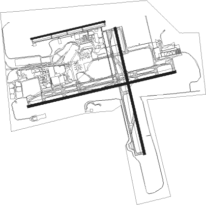
Runway info
Runway 8R / 26L  | ||
| length | 3041m (9977ft) | |
| bearing | 84° / 264° | |
| width | 46m (151ft) | |
| surface | concrete | |
| blast zone | 61m (200ft) / 61m (200ft) | |
| Runway 8L / 26R | ||
| length | 1521m (4990ft) | |
| bearing | 84° / 264° | |
| width | 30m (100ft) | |
| surface | asphalt | |
| Runway 17 / 35 | ||
| length | 2594m (8510ft) | |
| bearing | 168° / 348° | |
| width | 46m (151ft) | |
| surface | concrete | |
| blast zone | 61m (200ft) / 61m (200ft) | |
Nearby beacons
| code | identifier | dist | bearing | frequency |
|---|---|---|---|---|
| VIO | VICTORY VOR/DME | 5.7 | 165° | 115.95 |
| GR | KNOBS (GRAND RAPIDS) NDB | 6.4 | 84° | 263 |
| MKG | MUSKEGON TACAN | 28.5 | 299° | 115.20 |
| BT | BATOL (BATTLE CREEK) NDB | 34.5 | 147° | 272 |
| PMM | PULLMAN VOR/DME | 35.7 | 235° | 112.10 |
| AZO | KALAMAZOO VOR/DME | 38.6 | 183° | 109 |
| HIC | WHITE CLOUD VOR/DME | 42.5 | 344° | 117.60 |
| AZ | AUSTN (KALAMAZOO) NDB | 45 | 181° | 371 |
| ELX | KEELER VOR/DME | 51.5 | 219° | 116.60 |
| MOP | MOUNT PLEASANT VOR/DME | 56.2 | 47° | 110.60 |
| LFD | LITCHFIELD VOR/DME | 59.5 | 137° | 111.20 |
Instrument approach procedures
| runway | airway (heading) | route (dist, bearing) |
|---|---|---|
| RW08L | FIVLO (110°) | FIVLO HIPOP (13mi, 137°) 2700ft |
| RNAV | HIPOP 2700ft JELMO (6mi, 83°) 2400ft TECTU (2mi, 84°) 1620ft KGRR (3mi, 91°) 831ft (5208mi, 117°) 1037ft WAGMI (5203mi, 297°) CLOCK (17mi, 323°) 3000ft CLOCK (turn) | |
| RW17 | CLOCK (165°) | CLOCK WEBOM (5mi, 152°) 2600ft |
| RNAV | WEBOM 2600ft HABKO (6mi, 168°) 2400ft KGRR (5mi, 172°) 832ft (5208mi, 117°) 1108ft HONSE (5207mi, 297°) VIO (3mi, 167°) 3000ft VIO (turn) | |
| RW26L | UNSUN (286°) | UNSUN HAPIG (12mi, 315°) 2700ft |
| RNAV | HAPIG 2700ft CAVUS (6mi, 264°) 2700ft DAXEJ (3mi, 264°) 1640ft KGRR (3mi, 265°) 844ft (5208mi, 117°) 990ft FERLI (5214mi, 297°) JAKES (8mi, 263°) 2700ft JAKES (turn) | |
| RW26R | ORIEN (253°) | ORIEN FATOG (12mi, 245°) 3000ft |
| RNAV | FATOG 3000ft WAGMI (6mi, 264°) 2400ft KGRR (5mi, 259°) 834ft (5208mi, 117°) 1037ft JELMO (5214mi, 297°) CLOCK (16mi, 11°) 3000ft CLOCK (turn) | |
| RW35 | BOHRR (343°) | BOHRR JJUDD (6mi, 336°) 3000ft |
| RNAV | JJUDD 3000ft FALSU (6mi, 348°) 2500ft HONSE (3mi, 348°) 1480ft KGRR (3mi, 342°) 844ft (5208mi, 117°) 990ft HABKO (5209mi, 297°) CLOCK (11mi, 341°) 3000ft CLOCK (turn) |
Disclaimer
The information on this website is not for real aviation. Use this data with the X-Plane flight simulator only! Data taken with kind consent from X-Plane 12 source code and data files. Content is subject to change without notice.