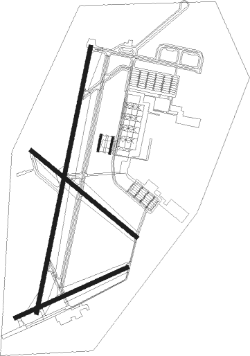
Fort Drum - Wheeler Sack Aaf
Airport details
| Country | United States of America |
| State | New York |
| Region | K6 |
| Airspace | Boston Ctr |
| Municipality | Town of Le Ray |
| Elevation | 687ft (209m) |
| Timezone | GMT -5 |
| Coordinates | 44.05561, -75.71989 |
| Magnetic var | |
| Type | land |
| Available since | X-Plane v10.40 |
| ICAO code | KGTB |
| IATA code | GTB |
| FAA code | GTB |
Communication
| WHEELER SACK AAF ATIS | 119.525 |
| WHEELER SACK AAF Ground Control | 121.900 |
| WHEELER SACK AAF Tower | 118.750 |
| WHEELER SACK AAF Approach/Departure | 128.250 |
Approach frequencies
| ILS-cat-I | RW03 | 108.5 | 18.00mi |
| ILS-cat-I | RW21 | 108.5 | 18.00mi |
| 3° GS | RW03 | 108.5 | 18.00mi |
| 3° GS | RW21 | 108.5 | 18.00mi |
Nearby Points of Interest:
State Street Historic District
-Thomas Memorial AME Zion Church
-Public Square
-Paddock Arcade
-Roswell P. Flower Memorial Library
-Watertown Masonic Temple
-Paddock Mansion
-Jefferson County Courthouse Complex
-Emma Flower Taylor Mansion
-William Archer House
-Gen. Jacob Brown Mansion
-La Farge Retainer Houses
-La Fargeville United Methodist Church
-La Farge Land Office
-Central Garage
-Dexter Universalist Church
-Dr. Abner Benton House
-Methodist Episcopal Church (Orleans, New York)
-Dr. Samuel Guthrie House
-George Brothers Building
-Madison Barracks
-Methodist-Protestant Church at Fisher's Landing
-Elisha Camp House
-Rock Island Light
-Franklin B. Hough House
Runway info
Nearby beacons
| code | identifier | dist | bearing | frequency |
|---|---|---|---|---|
| ART | WATERTOWN VORTAC | 16.1 | 253° | 109.80 |
| YGK | KINGSTON NDB | 40.7 | 285° | 263 |
| OG | OGIVE (OGDENSBURG) NDB | 41.8 | 30° | 358 |
| FZ | FALLN (FULTON) NDB | 52.6 | 217° | 220 |
| PTD | POTSDAM NDB | 53.8 | 51° | 400 |
| SYR | SYRACUSE VORTAC | 57.7 | 208° | 117 |
| MS | MISSE (MASSENA) NDB | 59 | 45° | 278 |
| MSS | MASSENA TACAN | 66.9 | 49° | 114.10 |
Departure and arrival routes
| Transition altitude | 18000ft |
| Transition level | 18000ft |
| SID end points | distance | outbound heading | |
|---|---|---|---|
| RW03 | |||
| ART2 | 16mi | 253° | |
| RW15 | |||
| ART2 | 16mi | 253° | |
| RW21 | |||
| ART2 | 16mi | 253° | |
| RW33 | |||
| ART2 | 16mi | 253° | |
Instrument approach procedures
| runway | airway (heading) | route (dist, bearing) |
|---|---|---|
| RW03 | ART (73°) | ART DOBTE (13mi, 153°) 5000ft FILOS (5mi, 102°) 5000ft |
| RW03 | FLOOR (19°) | FLOOR JESBI (16mi, 27°) 5000ft FILOS (5mi, 333°) 5000ft |
| RNAV | FILOS 5000ft KIMBO (13mi, 22°) 3000ft ZEBUK (3mi, 22°) 1880ft KGTB (4mi, 23°) 748ft WITED (16mi, 21°) 4000ft WITED (turn) | |
| RW15 | ART (73°) | ART JIGIB (11mi, 17°) 3000ft WOBDI (6mi, 59°) 3000ft |
| RW15 | WOBDI (125°) | WOBDI 3000ft |
| RNAV | WOBDI 3000ft KICPE (6mi, 125°) 2300ft KGTB (5mi, 126°) 706ft (4792mi, 120°) 1090ft WOBDI (4801mi, 300°) 3000ft WOBDI (turn) | |
| RW21 | ART (73°) | ART PIRTE (27mi, 41°) 3900ft WITED (5mi, 102°) 3900ft |
| RNAV | WITED 3900ft SHRAK (10mi, 202°) 2400ft KGTB (6mi, 201°) 724ft WODEG (3mi, 203°) ART (14mi, 261°) 3000ft ART (turn) | |
| RW33 | ART (73°) | ART JOGEG (21mi, 105°) 3600ft CEYAP (6mi, 52°) 3600ft |
| RW33 | CEYAP (304°) | CEYAP 3600ft |
| RNAV | CEYAP 3600ft TEGOC (6mi, 305°) 2800ft FOVAX (3mi, 305°) 1780ft KGTB (4mi, 303°) 730ft (4792mi, 120°) 1090ft CEYAP (4781mi, 300°) 3600ft CEYAP (turn) |
Disclaimer
The information on this website is not for real aviation. Use this data with the X-Plane flight simulator only! Data taken with kind consent from X-Plane 12 source code and data files. Content is subject to change without notice.

