Great Falls - Great Falls Intl
Airport details
| Country | United States of America |
| State | Montana |
| Region | K1 |
| Airspace | Salt Lake City Ctr |
| Municipality | Great Falls |
| Elevation | 3674ft (1120m) |
| Timezone | GMT -7 |
| Coordinates | 47.48265, -111.37061 |
| Magnetic var | |
| Type | land |
| Available since | X-Plane v10.40 |
| ICAO code | KGTF |
| IATA code | GTF |
| FAA code | GTF |
Communication
| Great Falls Intl ATIS | 126.600 |
| Great Falls Intl UNICOM | 122.950 |
| Great Falls Intl Ground Control/Clearance DEL | 121.700 |
| Great Falls Intl Tower | 118.700 |
| Great Falls Intl Approach/Departure | 128.600 |
Approach frequencies
| ILS-cat-III | RW03 | 111.3 | 18.00mi |
| 3° GS | RW03 | 111.3 | 18.00mi |
Nearby Points of Interest:
Timothy Edwards Collins Mansion
-Montana ExpoPark
-United States Post Office and Courthouse–Great Falls
-Cascade County Courthouse
-Masonic Temple
-Great Falls Portage
-J. C. Adams Stone Barn
-St. Peter's Mission Church and Cemetery
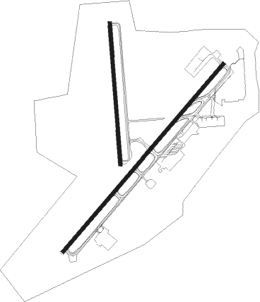
Runway info
Runway 3 / 21  | ||
| length | 3197m (10489ft) | |
| bearing | 56° / 236° | |
| width | 46m (150ft) | |
| surface | asphalt | |
| blast zone | 60m (197ft) / 255m (837ft) | |
| Runway 17 / 35 | ||
| length | 1837m (6027ft) | |
| bearing | 180° / 0° | |
| width | 46m (150ft) | |
| surface | asphalt | |
| displ threshold | 70m (230ft) / 0m (0ft) | |
| blast zone | 60m (197ft) / 64m (210ft) | |
Nearby beacons
| code | identifier | dist | bearing | frequency |
|---|---|---|---|---|
| GTF | GREAT FALLS VORTAC | 2.5 | 232° | 115.10 |
| HAU | HAUSER (HELENA) NDB | 57.1 | 203° | 386 |
| HLN | HELENA VORTAC | 57.7 | 214° | 117.70 |
Instrument approach procedures
| runway | airway (heading) | route (dist, bearing) |
|---|---|---|
| RW03-Y | GTF (52°) | GTF FRYMN (13mi, 236°) 8100ft FRYMN (turn) 8100ft |
| RW03-Y | HOXEK (35°) | HOXEK FRYMN (11mi, 356°) 8100ft |
| RW03-Y | ROSOE (77°) | ROSOE FRYMN (18mi, 93°) 8100ft |
| RW03-Y | WOKEN (53°) | WOKEN FRYMN (24mi, 51°) 8100ft |
| RNAV | FRYMN 8100ft DCEEE (8mi, 56°) 6000ft KGTF (8mi, 55°) 3734ft (6261mi, 113°) 3880ft DEELM (6256mi, 293°) PSHKN (11mi, 56°) 6200ft PSHKN (turn) | |
| RW03-Z | JAYKE (292°) | JAYKE BELLT (9mi, 261°) 5700ft AUERR (3mi, 281°) 5100ft TESTR (4mi, 360°) 4700ft |
| RW03-Z | KYELL (126°) | KYELL DVINT (9mi, 184°) 5300ft MUDLR (4mi, 128°) 5200ft TESTR (2mi, 76°) 4700ft |
| RW03-Z | MSURY (53°) | MSURY DCEEE (10mi, 51°) 5200ft TESTR (4mi, 56°) 4700ft |
| RW03-Z | PSHKN (236°) | PSHKN HANTZ (14mi, 257°) 6700ft KEPPR (8mi, 233°) 5400ft DVINT (2mi, 211°) 5300ft MUDLR (4mi, 128°) 5200ft TESTR (2mi, 76°) 4700ft |
| RW03-Z | SHIMY (88°) | SHIMY NIMPH (19mi, 94°) 6300ft MUDLR (7mi, 94°) 5200ft TESTR (2mi, 76°) 4700ft |
| RNAV | TESTR 4700ft KGTF (4mi, 53°) 3734ft DEELM (6mi, 58°) PSHKN (11mi, 56°) 6200ft PSHKN (turn) | |
| RW17 | GTF (52°) | GTF KNOWL (14mi, 10°) 6700ft KNOWL (turn) 6200ft |
| RW17 | JEBOB (134°) | JEBOB KNOWL (15mi, 109°) 6200ft |
| RW17 | RESLE (236°) | RESLE KNOWL (16mi, 263°) 6200ft |
| RNAV | KNOWL 6200ft GISKE (6mi, 180°) 5400ft KGTF (6mi, 179°) 3689ft (6261mi, 113°) 3910ft NICKH (6265mi, 293°) 9000ft NICKH (turn) | |
| RW21-Y | KAVMY (305°) | KAVMY SOTOW (16mi, 2°) 6500ft SOTOW (turn) 6200ft |
| RW21-Y | PSHKN (236°) | PSHKN SOTOW (5mi, 235°) 6200ft |
| RW21-Y | TUCKB (75°) | TUCKB SOTOW (25mi, 67°) 6200ft SOTOW (turn) 6200ft |
| RNAV | SOTOW 6200ft DEELM (6mi, 236°) 5300ft WAGAN (3mi, 236°) 4380ft KGTF (3mi, 239°) 3718ft (6261mi, 113°) 3869ft DCEEE (6268mi, 293°) TUCKB (7mi, 274°) 8000ft TUCKB (turn) | |
| RW21-Z | BRADZ (137°) | BRADZ WOLLY (40mi, 129°) 5500ft BDGER (5mi, 130°) 5400ft KUDEY (4mi, 184°) 4700ft |
| RW21-Z | DATSA (100°) | DATSA KEPPR (11mi, 104°) 5500ft JANON (8mi, 57°) 5500ft BDGER (4mi, 92°) 5400ft KUDEY (4mi, 184°) 4700ft |
| RW21-Z | PSHKN (236°) | PSHKN DRYFT (8mi, 235°) 5100ft KUDEY (5mi, 236°) 4700ft |
| RW21-Z | TUCKB (75°) | TUCKB KEPPR (8mi, 56°) 5500ft JANON (8mi, 57°) 5500ft BDGER (4mi, 92°) 5400ft KUDEY (4mi, 184°) 4700ft |
| RW21-Z | URELE (12°) | URELE ROWER (24mi, 29°) 8000ft PADDL (9mi, 29°) 5900ft WEDAR (3mi, 338°) 5100ft KUDEY (4mi, 268°) 4700ft |
| RW21-Z | YOGOS (286°) | YOGOS ZILEP (15mi, 298°) 6100ft WEDAR (5mi, 298°) 5100ft KUDEY (4mi, 268°) 4700ft |
| RNAV | KUDEY 4700ft KGTF (4mi, 238°) 3718ft ZETNI (5mi, 234°) UPIGY (7mi, 259°) TUCKB (3mi, 280°) 8000ft TUCKB (turn) 8000ft | |
| RW35 | GTF (52°) | GTF NICKH (12mi, 169°) 8000ft NICKH (turn) 8000ft |
| RW35 | HOXEK (35°) | HOXEK NICKH (14mi, 61°) 8000ft |
| RNAV | NICKH 8000ft CEVRO (7mi, 0°) 5800ft TEFFS (4mi, 0°) 4440ft KGTF (3mi, 3°) 3716ft (6261mi, 113°) 3918ft KNOWL (6258mi, 293°) 6200ft KNOWL (turn) |
Disclaimer
The information on this website is not for real aviation. Use this data with the X-Plane flight simulator only! Data taken with kind consent from X-Plane 12 source code and data files. Content is subject to change without notice.