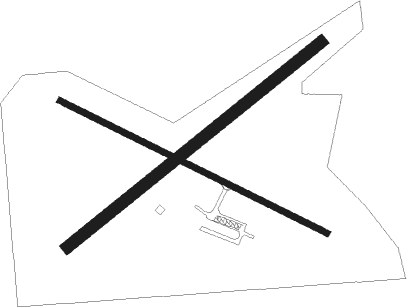
Grantsburg - Grantsburg Muni
Airport details
| Country | United States of America |
| State | Wisconsin |
| Region | K5 |
| Airspace | Minneapolis Ctr |
| Municipality | Grantsburg |
| Elevation | 925ft (282m) |
| Timezone | GMT -6 |
| Coordinates | 45.79838, -92.66433 |
| Magnetic var | |
| Type | land |
| Available since | X-Plane v10.40 |
| ICAO code | KGTG |
| IATA code | GTG |
| FAA code | GTG |
Communication
| Grantsburg Muni CTAF | 122.900 |
Nearby Points of Interest:
Burnett County Abstract Company
-Daniels Town Hall
-St. Croix Recreational Demonstration Area
-St. Croix State Park Fire Tower
-Snake River Fur Post
-Northern Pacific Depot
-Wild River State Park
-Polk County Courthouse
-Lamar Community Center
-Cushing Land Agency Building
-Thomas Henry Thompson House
-Taylors Falls Public Library
-Interstate State Park WPA/Rustic Style Historic Resources
-Center City Historic District
-Kanabec County Courthouse
-Isanti County Courthouse
Nearby beacons
| code | identifier | dist | bearing | frequency |
|---|---|---|---|---|
| RZN | DME | 12.2 | 86° | 109.40 |
| BXR | BIG DOCTOR (SIREN) NDB | 12.5 | 86° | 203 |
| ROS | RUSH CITY NDB | 13.6 | 251° | 282 |
| PNM | PRINCETON NDB | 41.9 | 256° | 368 |
| RP | WICKR (RICE LAKE) NDB | 46.3 | 119° | 221 |
| GEP | GOPHER (MINNEAPOLIS) VORTAC | 49.2 | 227° | 117.30 |
| MSP | MINNEAPOLIS VOR/DME | 59.3 | 212° | 115.30 |
| FCM | FLYING CLOUD (MINNEAPOLIS VOR/DME | 67 | 219° | 117.70 |
Instrument approach procedures
| runway | airway (heading) | route (dist, bearing) |
|---|---|---|
| RW12 | YIDUK (112°) | YIDUK 3400ft |
| RNAV | YIDUK 3400ft WOVUR (7mi, 112°) 2500ft ZELPU (3mi, 113°) 1440ft KGTG (2mi, 112°) 964ft (5517mi, 116°) 1300ft WUGAX (5507mi, 296°) 3400ft WUGAX (turn) | |
| RW30 | WUGAX (293°) | WUGAX 3400ft |
| RNAV | WUGAX 3400ft OSVEC (7mi, 293°) 2500ft VITUY (3mi, 293°) 1500ft KGTG (2mi, 293°) 974ft (5517mi, 116°) 1320ft YIDUK (5527mi, 296°) 3400ft YIDUK (turn) |
Disclaimer
The information on this website is not for real aviation. Use this data with the X-Plane flight simulator only! Data taken with kind consent from X-Plane 12 source code and data files. Content is subject to change without notice.

