Gainesville - Gainsville - Lee Gilmer Mem
Airport details
| Country | United States of America |
| State | Georgia |
| Region | K7 |
| Airspace | Atlanta Ctr |
| Municipality | Gainesville |
| Elevation | 1272ft (388m) |
| Timezone | GMT -5 |
| Coordinates | 34.27263, -83.83022 |
| Magnetic var | |
| Type | land |
| Available since | X-Plane v10.40 |
| ICAO code | KGVL |
| IATA code | GVL |
| FAA code | GVL |
Communication
| Gainsville - Lee Gilmer Mem ASOS | 126.475 |
| Gainsville - Lee Gilmer Mem CTAF/UNICOM | 123.075 |
| Gainsville - Lee Gilmer Mem ATLANTA Approach/Departure | 134.800 |
Approach frequencies
| ILS-cat-I | RW05 | 110.55 | 18.00mi |
| 3° GS | RW05 | 110.55 | 18.00mi |
Nearby Points of Interest:
Old Hall County Courthouse
-Gainesville Commercial Historic District
-Federal Building and U.S. Courthouse
-Beulah Rucker House-School
-Bowman-Pirkle House
-John Quincy Allen House
-Calhoun Mine
-Boyd and Sallie Gilleland House
-Price Memorial Hall
-Fields Place-Vickery House
-Fort Hollingsworth–White House
-Lumpkin County Jail
-Barrow County Courthouse
-Gwinnett County Courthouse
-Old Seminary Building
-Kilgore Mill Covered Bridge and Mill Site
-William Harris Homestead
-Superb
-Walnut Hill Historic District
-Hamilton Historic District
-Mauldin House
-Henry Asbury House
-Newtown Elementary School
-Sautee Valley Historic District
-Ball Ground Historic District
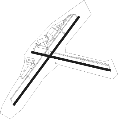
Runway info
Runway 5 / 23  | ||
| length | 1677m (5502ft) | |
| bearing | 46° / 226° | |
| width | 30m (100ft) | |
| surface | asphalt | |
| displ threshold | 0m (0ft) / 121m (397ft) | |
| blast zone | 46m (151ft) / 46m (151ft) | |
| Runway 11 / 29 | ||
| length | 1218m (3996ft) | |
| bearing | 105° / 285° | |
| width | 30m (100ft) | |
| surface | asphalt | |
| displ threshold | 39m (128ft) / 35m (115ft) | |
Nearby beacons
| code | identifier | dist | bearing | frequency |
|---|---|---|---|---|
| FKV | FLOWERY BRANCH (GAINESVILLE) NDB | 5.6 | 228° | 365 |
| TX | GWNET (LAWRENCEVILLE) NDB | 15.2 | 187° | 419 |
| BMW | BARROW COUNTY (WINDER) NDB | 23.5 | 144° | 404 |
| AHN | ATHENS VOR/DME | 31.8 | 123° | 109.60 |
| DJD | CHERO NDB | 32.6 | 268° | 415 |
| PDK | PEACHTREE (ATLANTA) VOR/DME | 33.3 | 230° | 116.60 |
| ODF | FOOTHILLS (TOCCOA) VOR/DME | 36.6 | 52° | 113.40 |
| VOF | ALCOVY (COVINGTON) NDB | 38.6 | 176° | 370 |
| DOB | DOBBINS (MARIETTA) TACAN | 39.9 | 242° | 113 |
| HRS | HARRIS VORTAC | 40.4 | 353° | 109.80 |
| ATL | ATLANTA VORTAC | 49 | 223° | 116.90 |
| AT | CATTA (ATLANTA) NDB | 51.6 | 229° | 375 |
| VV | JUNNE (GREENSBORO) NDB | 55.1 | 128° | 353 |
| FFC | PECAT (ATLANTA) NDB | 66.9 | 214° | 316 |
Departure and arrival routes
| Transition altitude | 18000ft |
| Transition level | 18000ft |
| STAR starting points | distance | inbound heading | |
|---|---|---|---|
| ALL | |||
| DIFFI4 | 100.6 | 48° | |
| BOKRT3 | 89.4 | 52° | |
Instrument approach procedures
| runway | airway (heading) | route (dist, bearing) |
|---|---|---|
| RW05 | AWSON (143°) | AWSON HADUD (19mi, 196°) 4000ft IYULU (5mi, 126°) 3100ft |
| RW05 | CONLY (325°) | CONLY ETAKE (12mi, 270°) 3700ft IYULU (5mi, 306°) 3100ft |
| RNAV | IYULU 3100ft FLAWR (6mi, 46°) 3100ft KGVL (6mi, 47°) 1317ft SOGDE (5mi, 45°) MACEY (4mi, 88°) 4000ft MACEY (turn) 4000ft | |
| RW23 | ANNYE (166°) | ANNYE JATOX (10mi, 125°) 5000ft DUBNE (5mi, 126°) 3500ft |
| RW23 | IRMOS (278°) | IRMOS FEGTA (12mi, 313°) 3800ft DUBNE (5mi, 306°) 3500ft |
| RNAV | DUBNE 3500ft BUYAC (6mi, 226°) 3000ft LAGME (2mi, 226°) 2220ft KGVL (3mi, 225°) 1280ft ZADIT (3mi, 228°) WOMAC (7mi, 200°) 4000ft WOMAC (turn) 4000ft |
Holding patterns
| STAR name | hold at | type | turn | heading* | altitude | leg | speed limit |
|---|---|---|---|---|---|---|---|
| DIFFI4 | LGC | NDB | right | 228 (48)° | 1.0min timed | ICAO rules | |
| *) magnetic outbound (inbound) holding course | |||||||
Disclaimer
The information on this website is not for real aviation. Use this data with the X-Plane flight simulator only! Data taken with kind consent from X-Plane 12 source code and data files. Content is subject to change without notice.