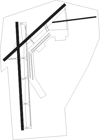
Greenwood - Greenwood Leflore
Airport details
| Country | United States of America |
| State | Mississippi |
| Region | K7 |
| Airspace | Memphis Ctr |
| Municipality | Carroll County |
| Elevation | 162ft (49m) |
| Timezone | GMT -6 |
| Coordinates | 33.49430, -90.08480 |
| Magnetic var | |
| Type | land |
| Available since | X-Plane v10.40 |
| ICAO code | KGWO |
| IATA code | GWO |
| FAA code | GWO |
Communication
| GREENWOOD LEFLORE ASOS | 119.975 |
| GREENWOOD LEFLORE CTAF | 118.350 |
| GREENWOOD LEFLORE UNICOM | 122.950 |
| GREENWOOD LEFLORE Ground Control | 125.550 |
| GREENWOOD LEFLORE Tower | 118.350 |
Approach frequencies
| ILS-cat-I | RW18 | 111.3 | 18.00mi |
| 3° GS | RW18 | 111.3 | 18.00mi |
Nearby Points of Interest:
Wesley Memorial Methodist Episcopal
-Southworth House
-Cotesworth
-Acona Church, Cemetery, and School
-Immanuel Episcopal Church
-Odd Fellows and Confederate Cemetery
-Grenada Masonic Temple
-Jaketown Site
-Ruleville Depot
-Indianola Historic District
-Dockery Plantation
-Woodburn Bridge
-Tallahatchie County Courthouse
-Heathman Plantation
Nearby beacons
| code | identifier | dist | bearing | frequency |
|---|---|---|---|---|
| GW | TEOCK NDB | 5.8 | 0° | 349 |
| SQS | SIDON VORTAC | 9.8 | 261° | 114.70 |
| GLH | GREENVILLE VOR/DME | 45 | 272° | 114.25 |
| MTQ | METCALF (GREENVILLE) NDB | 45.1 | 266° | 359 |
| UV | TUNNG (OXFORD) NDB | 58.1 | 27° | 426 |
Instrument approach procedures
| runway | airway (heading) | route (dist, bearing) |
|---|---|---|
| RW05 | HIVBI (58°) | HIVBI 2500ft |
| RNAV | HIVBI 2500ft PORIY (8mi, 57°) 1700ft ZESBU (3mi, 57°) 700ft KGWO (2mi, 61°) 175ft (5409mi, 110°) 600ft HIVBI (5420mi, 290°) 2500ft HIVBI (turn) | |
| RW18 | ZUBUK (181°) | ZUBUK 2100ft |
| RNAV | ZUBUK 2100ft EGCUP (8mi, 182°) 2100ft JOBIV (4mi, 182°) 720ft KGWO (2mi, 176°) 196ft (5409mi, 110°) 471ft YECUD (5410mi, 290°) 2100ft YECUD (turn) | |
| RW36 | YECUD (3°) | YECUD 2100ft |
| RNAV | YECUD 2100ft KUBBY (8mi, 2°) 1900ft WABAV (3mi, 2°) 980ft KGWO (3mi, 5°) 189ft (5409mi, 110°) 389ft ZUBUK (5409mi, 291°) 2100ft ZUBUK (turn) |
Disclaimer
The information on this website is not for real aviation. Use this data with the X-Plane flight simulator only! Data taken with kind consent from X-Plane 12 source code and data files. Content is subject to change without notice.

