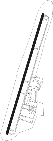
Asheboro - Asheboro Rgnl
Airport details
| Country | United States of America |
| State | North Carolina |
| Region | K7 |
| Airspace | Atlanta Ctr |
| Municipality | Asheboro |
| Elevation | 670ft (204m) |
| Timezone | GMT -5 |
| Coordinates | 35.65453, -79.89475 |
| Magnetic var | |
| Type | land |
| Available since | X-Plane v10.32 |
| ICAO code | KHBI |
| IATA code | n/a |
| FAA code | HBI |
Communication
| Asheboro Rgnl AWOS 3 | 119.275 |
| Asheboro Rgnl CTAF/UNICOM | 122.800 |
| Asheboro Rgnl AI Traffic | 128.800 |
| Asheboro Rgnl GREENSBORO Approach/Departure | 118.500 |
Nearby Points of Interest:
Lewis-Thornburg Farm
-Randolph County Courthouse
-Franklinville Historic District
-Randleman Graded School
-Coleridge Historic District
-Jugtown Pottery
-Moses Hammond House
-Randolph Street Historic District
-Smith Clinic
-Thomasville Railroad Passenger Depot
-Mitchell House
-Church Street School
-Narrows Dam and Power Plant Complex
-Marley House
-Montgomery County Courthouse
-Highland Cotton Mills Village Historic District
-Pickett Cotton Mills
-Carolina Casket Company
-Guilford County Office and Court Building
-O. Arthur Kirkman House and Outbuildings
-Market Square
-West High Street Historic District
-College Hill, Greensboro, North Carolina
-Oakwood Historic District
-Enterprise Building
Nearby beacons
| code | identifier | dist | bearing | frequency |
|---|---|---|---|---|
| VU | ALLER (ALBEMARLE) NDB | 13.5 | 229° | 346 |
| LIB | LIBERTY VORTAC | 16.6 | 61° | 113 |
| GSO | GREENSBORO VORTAC | 23.8 | 348° | 116.20 |
| HB | ALAMM NDB | 24.6 | 44° | 361 |
| IN | REENO (WINSTON SALEM) NDB | 28.3 | 327° | 317 |
| RU | ROVDY (SALISBURY) NDB | 29.3 | 278° | 275 |
| SDZ | SANDHILLS (SOUTHERN PINES VORTAC | 30.3 | 145° | 111.80 |
| SIF | SLAMMER (REIDSVILLE) NDB | 44.1 | 10° | 423 |
| POB | POPE (FAYETTEVILLE) TACAN | 51.8 | 119° | 113.80 |
| POB | POPE (FAYETTEVILLE) NDB | 52.6 | 114° | 338 |
| HUR | PERSON (ROXBORO) NDB | 53.2 | 55° | 220 |
| UV | BALES (MARTINSVILLE) NDB | 56.1 | 359° | 396 |
| ME | MAXTN (MAXTON) NDB | 59.5 | 154° | 257 |
| DAN | DANVILLE VOR | 61.2 | 31° | 113.10 |
| LKR | LANCASTER NDB | 73.2 | 226° | 400 |
Instrument approach procedures
| runway | airway (heading) | route (dist, bearing) |
|---|---|---|
| RW03 | EETEE (319°) | EETEE OVUVE (8mi, 275°) 3300ft FAPOG (8mi, 299°) 3300ft |
| RW03 | GANTS (46°) | GANTS FAPOG (7mi, 72°) 3300ft |
| RNAV | FAPOG 3300ft GABNE (5mi, 26°) 2500ft KHBI (5mi, 26°) 721ft (4913mi, 114°) 1920ft KEWPI (4921mi, 294°) 3000ft KEWPI (turn) | |
| RW21 | CEEDE (190°) | CEEDE HABUG (6mi, 142°) 3700ft |
| RW21 | LIB (241°) | LIB HABUG (8mi, 273°) 3700ft |
| RNAV | HABUG 3700ft COLUN (5mi, 222°) 2600ft HUGIS (3mi, 206°) 1680ft KHBI (4mi, 206°) 708ft (4913mi, 114°) 3000ft KEWPI (4921mi, 294°) 3000ft KEWPI (turn) |
Disclaimer
The information on this website is not for real aviation. Use this data with the X-Plane flight simulator only! Data taken with kind consent from X-Plane 12 source code and data files. Content is subject to change without notice.
