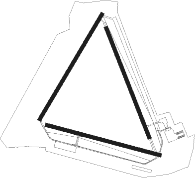
Camp Mackall - Mackall Aaf
Airport details
| Country | United States of America |
| State | North Carolina |
| Region | K7 |
| Airspace | Washington Ctr |
| Municipality | Richmond County |
| Elevation | 375ft (114m) |
| Timezone | GMT -5 |
| Coordinates | 35.03661, -79.49731 |
| Magnetic var | |
| Type | land |
| Available since | X-Plane v10.40 |
| ICAO code | KHFF |
| IATA code | HFF |
| FAA code | HFF |
Communication
| Mackall AAF Ground Control | 128.350 |
| Mackall AAF Tower | 121.000 |
| Mackall AAF FAYETTEVILLE Approach/Departure | 127.800 |
Nearby Points of Interest:
Aberdeen Historic District
-Malcolm Blue Farm
-Lloyd-Howe House
-Southern Pines Historic District
-Mystic Cottage
-James Boyd House
-Shaw Family Farms
-Laurinburg Commercial Historic District
-Roberdel Mill No. 1 Company Store
-Mill Prong
-Main Street Commercial Historic District
-Raeford Historic District
-Hoke County Courthouse
-Rockingham Historic District
-Bostick School
-Manufacturers Building
-Bank of Pee Dee Building
-U. S. Post Office and Federal Building
-Rockingham County Courthouse
-Richmond County Courthouse
-Alfred Dockery House
-E. Hervey Evans House
-Thomas J. Gill House
-Villa Nova
-John Blue House
Runway info
Nearby beacons
| code | identifier | dist | bearing | frequency |
|---|---|---|---|---|
| SDZ | SANDHILLS (SOUTHERN PINES VORTAC | 11.6 | 333° | 111.80 |
| ME | MAXTN (MAXTON) NDB | 18.4 | 170° | 257 |
| POB | POPE (FAYETTEVILLE) TACAN | 24.7 | 75° | 113.80 |
| BES | BENNETTSVILLE NDB | 27.5 | 210° | 230 |
| POB | POPE (FAYETTEVILLE) NDB | 29 | 71° | 338 |
| FAY | FAYETTEVILLE VOR/DME | 30.7 | 95° | 108.80 |
| FGP | FORT BRAGG NDB | 34.1 | 81° | 393 |
| JB | JIGEL (LUMBERTON) NDB | 34.3 | 144° | 384 |
| DLC | DILLON NDB | 35.7 | 168° | 274 |
| VU | ALLER (ALBEMARLE) NDB | 39.5 | 308° | 346 |
| UDG | DARLINGTON NDB | 40.5 | 213° | 245 |
| CTF | CHESTERFIELD VOR/DME | 44.7 | 244° | 108.20 |
| HQT | HARNETT (ERWIN) NDB | 46.8 | 64° | 417 |
| LIB | LIBERTY VORTAC | 46.8 | 352° | 113 |
| HVS | HARTSVILLE NDB | 48.7 | 225° | 341 |
| FLO | FLORENCE VORTAC | 48.9 | 191° | 115.20 |
| FL | ALCOT (FLORENCE) NDB | 54.6 | 202° | 335 |
| HB | ALAMM NDB | 56.7 | 355° | 361 |
| CPC | CAMP (WHITEVILLE) NDB | 60 | 134° | 227 |
| RDU | RALEIGH-DURHAM VORTAC | 61.1 | 41° | 117.20 |
| RU | ROVDY (SALISBURY) NDB | 64.1 | 305° | 275 |
| LE | LEEVY (RALEIGH/DURHAM) NDB | 65.5 | 41° | 350 |
Instrument approach procedures
| runway | airway (heading) | route (dist, bearing) |
|---|---|---|
| RW12 | AAMMO (105°) | AAMMO 2400ft |
| RW12 | ITGUY (133°) | ITGUY 2400ft AAMMO (8mi, 203°) 2400ft |
| RW12 | JOGTU (80°) | JOGTU 2400ft AAMMO (8mi, 23°) 2400ft |
| RNAV | AAMMO 2400ft DAZED (8mi, 106°) 2100ft FIGHT (2mi, 106°) 1440ft KHFF (4mi, 102°) 430ft (4890mi, 114°) 575ft HITIT (4876mi, 294°) 2100ft HITIT (turn) 6000ft | |
| RW30 | HITIT (287°) | HITIT 2100ft |
| RW30 | KEFFR (315°) | KEFFR 2100ft HITIT (8mi, 23°) 2100ft |
| RW30 | MABOZ (262°) | MABOZ 2200ft HITIT (8mi, 203°) 2100ft |
| RNAV | HITIT 2100ft LENRD (8mi, 286°) 2100ft PARKY (2mi, 286°) 1400ft KHFF (4mi, 290°) 387ft (4890mi, 114°) 602ft AAMMO (4903mi, 294°) 2400ft AAMMO (turn) 6000ft |
Disclaimer
The information on this website is not for real aviation. Use this data with the X-Plane flight simulator only! Data taken with kind consent from X-Plane 12 source code and data files. Content is subject to change without notice.

