Hebron - Hebron Muni
Airport details
| Country | United States of America |
| State | Nebraska |
| Region | K3 |
| Airspace | Minneapolis Ctr |
| Municipality | Thayer County |
| Elevation | 1466ft (447m) |
| Timezone | GMT -6 |
| Coordinates | 40.15194, -97.58453 |
| Magnetic var | |
| Type | land |
| Available since | X-Plane v10.40 |
| ICAO code | KHJH |
| IATA code | n/a |
| FAA code | HJH |
Communication
| Hebron Muni AWOS3 | 118.525 |
| Hebron Muni CTAF | 122.900 |
Nearby Points of Interest:
Hebron United States Post Office
-Richard E. Dill House
-Strang School District No. 36
-Jefferson County Courthouse
-IOOF Temple Building
-Fairbury Public Library
-Pawnee Indian Museum State Historic Site
-Nuckolls County Courthouse
-The Auditorium
-George W. Smith House
-Cesko-narodni sin-Milligan Auditorium
-Nelson Cemetery Walk
-Wallace Warren and Lillian Genevieve Bradshaw Kendall House
-Fairmont State Airfield
-Rad Saline Center cis. 389 Z.C.B.J.
-Fairfield Carnegie Library
-County Line Bowstring
-Colman House
-Isaac Newton Clark House
Runway info
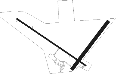
Runway 12 / 30  | ||
| length | 1098m (3602ft) | |
| bearing | 121° / 301° | |
| width | 18m (60ft) | |
| surface | concrete | |
| Runway 03 / 21 | ||
| length | 766m (2513ft) | |
| bearing | 49° / 229° | |
| width | 46m (150ft) | |
| surface | grass | |
Nearby beacons
| code | identifier | dist | bearing | frequency |
|---|---|---|---|---|
| FBY | FAIRBURY NDB | 19.2 | 87° | 293 |
| FMZ | BEKLOF (FAIRMONT) NDB | 26.3 | 2° | 392 |
| TKO | MANKATO VORTAC | 37.3 | 243° | 109.80 |
| BIE | BEATRICE VOR | 39 | 80° | 110.60 |
| JYR | YORK NDB | 44.8 | 358° | 257 |
| HSI | HASTINGS VOR/DME | 47.2 | 298° | 108.80 |
| LN | POTTS (LINCOLN) NDB | 51.8 | 54° | 385 |
| GR | SANCY NDB | 54.6 | 315° | 380 |
| GRI | GRAND ISLAND VOR/DME | 60 | 319° | 112 |
| LNK | LINCOLN VORTAC | 60.2 | 48° | 116.10 |
Disclaimer
The information on this website is not for real aviation. Use this data with the X-Plane flight simulator only! Data taken with kind consent from X-Plane 12 source code and data files. Content is subject to change without notice.