Helena - Helena Regl
Airport details
| Country | United States of America |
| State | Montana |
| Region | K1 |
| Airspace | Salt Lake City Ctr |
| Municipality | Helena |
| Elevation | 3875ft (1181m) |
| Timezone | GMT -7 |
| Coordinates | 46.60671, -111.98335 |
| Magnetic var | |
| Type | land |
| Available since | X-Plane v10.40 |
| ICAO code | KHLN |
| IATA code | HLN |
| FAA code | HLN |
Communication
| Helena Regl ATIS | 120.400 |
| Helena Regl CTAF | 118.300 |
| Helena Regl UNICOM | 122.950 |
| Helena Regl Ground Control | 121.900 |
| Helena Regl Tower | 118.300 |
| Helena Regl Approach | 119.500 |
| Helena Regl Departure | 119.500 |
Approach frequencies
| ILS-cat-I | RW27 | 110.1 | 18.00mi |
| 3° GS | RW27 | 110.1 | 18.00mi |
Nearby Points of Interest:
Montana Veterans and Pioneers Memorial Building
-Montana State Capitol
-Wick-Seiler House
-Morris Silverman House
-Robert and Elizabeth Fisk House
-Porter Flats Apartments
-Lewis and Clark County Hospital Historic District
-Helena Civic Center
-Kluge House
-Olsen House
-Hauser Mansion
-Helena Historic District
-Forestvale Cemetery
-W.C. Child Ranch
-Mann Gulch fire
-Eagle Guard Station
-Jefferson County Courthouse
-Montana Deaf and Dumb Asylum
-St. Joseph's Catholic Mission Church
-State Bank of Townsend
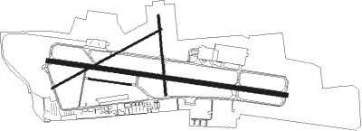
Runway info
Runway 9 / 27  | ||
| length | 2736m (8976ft) | |
| bearing | 99° / 279° | |
| width | 46m (150ft) | |
| surface | asphalt | |
| blast zone | 61m (200ft) / 61m (200ft) | |
| Runway 5 / 23 | ||
| length | 1412m (4633ft) | |
| bearing | 73° / 253° | |
| width | 23m (75ft) | |
| surface | asphalt | |
| Runway 17 / 35 | ||
| length | 911m (2989ft) | |
| bearing | 179° / 359° | |
| width | 23m (75ft) | |
| surface | asphalt | |
| Runway 10 / 28 | ||
| length | 484m (1588ft) | |
| bearing | 99° / 279° | |
| width | 15m (50ft) | |
| surface | grass | |
Nearby beacons
| code | identifier | dist | bearing | frequency |
|---|---|---|---|---|
| HLN | HELENA VORTAC | 1.2 | 90° | 117.70 |
| HAU | HAUSER (HELENA) NDB | 9.5 | 100° | 386 |
| HIA | WHITEHALL VOR/DME | 45.4 | 194° | 113.70 |
| CPN | COPPERTOWN (BUTTE) VOR/DME | 46.8 | 233° | 111.60 |
| BZ | MANNI (BOZEMAN) NDB | 52.7 | 136° | 266 |
| GTF | GREAT FALLS VORTAC | 55.7 | 34° | 115.10 |
| BZN | BOZEMAN VOR/DME | 60.2 | 135° | 112.40 |
Departure and arrival routes
| Transition altitude | 18000ft |
| Transition level | 18000ft |
| SID end points | distance | outbound heading | |
|---|---|---|---|
| RW09 | |||
| STAKK4 | 22mi | 89° | |
| SIEBE3 | 18mi | 329° | |
| RW27 | |||
| STAKK4 | 22mi | 89° | |
| SIEBE3 | 18mi | 329° | |
Instrument approach procedures
| runway | airway (heading) | route (dist, bearing) |
|---|---|---|
| RW09-Y | GLUES (77°) | GLUES KELTY (18mi, 52°) 9800ft DOMVE (7mi, 95°) 8000ft |
| RW09-Y | HLN (270°) | HLN KELTY (20mi, 276°) 9800ft KELTY (turn) 9800ft DOMVE (7mi, 95°) 8000ft |
| RW09-Y | PIXXI (99°) | PIXXI KELTY (12mi, 102°) 9800ft DOMVE (7mi, 95°) 8000ft |
| RNAV | DOMVE 8000ft AXOBE (2mi, 95°) 7400ft CENET (3mi, 99°) 6440ft KHLN (7mi, 99°) 3914ft (6300mi, 113°) 4280ft SIEBE (6302mi, 293°) 9000ft SIEBE (turn) | |
| RW09-Z | GLUES (77°) | GLUES KELTY (18mi, 52°) 9000ft |
| RW09-Z | HLN (270°) | HLN BENZE (18mi, 243°) 10000ft FEXAD (14mi, 281°) 10000ft KELTY (13mi, 48°) 9000ft |
| RW09-Z | PIXXI (99°) | PIXXI KELTY (12mi, 102°) 9000ft |
| RNAV | KELTY 9000ft HIRSA (6mi, 95°) 8200ft JEBSI (4mi, 95°) 7100ft KHLN (9mi, 99°) 3919ft BOSCA (14mi, 99°) URELE (25mi, 24°) 12000ft URELE (turn) | |
| RW27-X | SWEDD (290°) | SWEDD GASBE (6mi, 334°) 8000ft |
| RNAV | GASBE 8000ft BIBDE (6mi, 279°) 7100ft KHLN (11mi, 279°) 3900ft EKIKE (6mi, 279°) WOKEN (22mi, 16°) 9300ft WOKEN (turn) 9300ft | |
| RW27-Y | HEXOL (270°) | HEXOL FALDE (15mi, 270°) 9000ft BOSCA (6mi, 247°) 7200ft |
| RW27-Y | HIA (14°) | HIA SUZZY (18mi, 48°) 10500ft FAVTA (20mi, 53°) 9100ft BOSCA (13mi, 336°) 7200ft |
| RW27-Y | HLN (270°) | HLN CEMLI (11mi, 165°) 10000ft DULCA (11mi, 121°) 10000ft FAVTA (6mi, 74°) 9000ft BOSCA (13mi, 336°) 7200ft |
| RW27-Y | LINGE (259°) | LINGE FALDE (17mi, 247°) 9000ft BOSCA (6mi, 247°) 7200ft |
| RW27-Y | SWEDD (290°) | SWEDD BOSCA (8mi, 313°) 7200ft |
| RW27-Y | URELE (235°) | URELE FALDE (21mi, 188°) 9300ft BOSCA (6mi, 247°) 7200ft |
| RNAV | BOSCA 7200ft JEXUT (5mi, 279°) 6500ft KHLN (9mi, 279°) 3900ft ZEKSA (1mi, 278°) MUSEW (4mi, 279°) JEBSI (4mi, 279°) KELTY (10mi, 275°) PIXXI (12mi, 282°) 13000ft PIXXI (turn) | |
| RW27-Z | HEXOL (270°) | HEXOL FALDE (15mi, 270°) 9000ft BOSCA (6mi, 247°) 7200ft |
| RW27-Z | HIA (14°) | HIA SUZZY (18mi, 48°) 10500ft FAVTA (20mi, 53°) 9100ft BOSCA (13mi, 336°) 7200ft |
| RW27-Z | HLN (270°) | HLN CEMLI (11mi, 165°) 10000ft DULCA (11mi, 121°) 10000ft FAVTA (6mi, 74°) 9000ft BOSCA (13mi, 336°) 7200ft |
| RW27-Z | LINGE (259°) | LINGE FALDE (17mi, 247°) 9000ft BOSCA (6mi, 247°) 7200ft |
| RW27-Z | SUZZY (350°) | SUZZY FAVTA (20mi, 53°) 9100ft BOSCA (13mi, 336°) 7200ft |
| RW27-Z | SWEDD (290°) | SWEDD BOSCA (8mi, 313°) 7200ft |
| RW27-Z | URELE (235°) | URELE FALDE (21mi, 188°) 9300ft BOSCA (6mi, 247°) 7200ft |
| RNAV | BOSCA 7200ft JEXUT (5mi, 279°) 6500ft KHLN (9mi, 279°) 3900ft JEBSI (9mi, 279°) KELTY (10mi, 275°) PIXXI (12mi, 282°) 13000ft PIXXI (turn) |
Disclaimer
The information on this website is not for real aviation. Use this data with the X-Plane flight simulator only! Data taken with kind consent from X-Plane 12 source code and data files. Content is subject to change without notice.