Alamogordo - Holloman Afb
Airport details
| Country | United States of America |
| State | New Mexico |
| Region | K2 |
| Airspace | Albuquerque Ctr |
| Municipality | Otero County |
| Elevation | 4090ft (1247m) |
| Timezone | GMT -7 |
| Coordinates | 32.85808, -106.09024 |
| Magnetic var | |
| Type | land |
| Available since | X-Plane v10.40 |
| ICAO code | KHMN |
| IATA code | HMN |
| FAA code | HMN |
Communication
| Holloman AFB Holloman Clearance | 126.700 |
| Holloman AFB Holloman Ground | 127.050 |
| Holloman AFB Holloman Tower | 119.300 |
| Holloman AFB Holloman Approach | 120.600 |
| Holloman AFB Holloman Departure | 128.100 |
Approach frequencies
| ILS-cat-I | RW22 | 111.7 | 18.00mi |
| ILS-cat-I | RW16 | 108.9 | 18.00mi |
| 3° GS | RW22 | 111.7 | 18.00mi |
| 2.5° GS | RW16 | 108.9 | 18.00mi |
Nearby Points of Interest:
White Sands National Park Historic District
-Lincoln National Forest Service Building
-Alamogordo Woman's Club
-Jackson House
-Queen Anne House
-La Luz Pottery Factory
-White Sands V-2 Launching Site
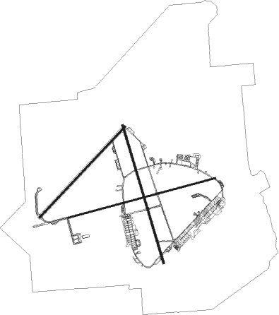
Runway info
Runway 7 / 25  | ||
| length | 3932m (12900ft) | |
| bearing | 81° / 261° | |
| width | 46m (150ft) | |
| surface | concrete | |
| blast zone | 0m (0ft) / 255m (837ft) | |
| Runway 16 / 34 | ||
| length | 3709m (12169ft) | |
| bearing | 166° / 346° | |
| width | 46m (150ft) | |
| surface | asphalt | |
| blast zone | 255m (837ft) / 255m (837ft) | |
| Runway 4 / 22 | ||
| length | 3225m (10581ft) | |
| bearing | 53° / 233° | |
| width | 46m (150ft) | |
| surface | asphalt | |
| blast zone | 255m (837ft) / 255m (837ft) | |
Airport layout
Parking locations
|
Nearby beacons
| code | identifier | dist | bearing | frequency |
|---|---|---|---|---|
| HMN | HOLLOMAN (ALAMOGORDO) TACAN | 0.9 | 282° | 114.50 |
| BWS | (ALAMOGORDO) DME | 4.4 | 116° | 109.60 |
| PIO | PINON VOR/DME | 44.3 | 113° | 110.40 |
| CEP | CAPITAN (RUIDOSO) NDB | 51.2 | 47° | 278 |
| EWM | NEWMAN VORTAC | 55.2 | 191° | 112.40 |
| EL | VALTR (EL PASO) NDB | 61 | 193° | 242 |
Departure and arrival routes
| Transition altitude | 18000ft |
| Transition level | 18000ft |
| SID end points | distance | outbound heading | |
|---|---|---|---|
| RW04 | |||
| ZOVOS1 | 22mi | 11° | |
| RW16 | |||
| ZOVOS1 | 22mi | 11° | |
| CLOUA4, CLOUB4 | 13mi | 87° | |
| IZZYY1 | 17mi | 324° | |
| RW22 | |||
| ZOVOS1 | 22mi | 11° | |
| CLOUA4, CLOUB4 | 13mi | 87° | |
| IZZYY1 | 17mi | 324° | |
| RW25 | |||
| ZOVOS1 | 22mi | 11° | |
| CLOUA4, CLOUB4 | 13mi | 87° | |
| IZZYY1 | 17mi | 324° | |
| RW34 | |||
| ZOVOS1 | 22mi | 11° | |
Instrument approach procedures
| runway | airway (heading) | route (dist, bearing) |
|---|---|---|
| RW16 | JEMTO (162°) | JEMTO 8000ft |
| RNAV | JEMTO 8000ft FAGUS (4mi, 166°) 6900ft FETER (5mi, 166°) 5800ft KHMN (6mi, 158°) 4134ft (6214mi, 107°) 5000ft JOBAM (6219mi, 287°) 7000ft JOBAM (turn) 10000ft | |
| RW22 | KASTL (230°) | KASTL 11000ft COPOR (4mi, 233°) 10200ft DACAG (5mi, 233°) 10000ft LEVAK (3mi, 233°) 7600ft |
| RNAV | LEVAK 7600ft DANLE (3mi, 233°) 6800ft CIMVU (4mi, 233°) 5700ft JOGDI (2mi, 233°) 4900ft KHMN (2mi, 208°) 4135ft (6214mi, 107°) 5000ft JOBAM (6219mi, 287°) 7000ft JOBAM (turn) |
Disclaimer
The information on this website is not for real aviation. Use this data with the X-Plane flight simulator only! Data taken with kind consent from X-Plane 12 source code and data files. Content is subject to change without notice.