Houston - William P Hobby
Airport details
| Country | United States of America |
| State | Texas |
| Region | K4 |
| Airspace | Houston Oceanic Ctr |
| Municipality | Houston |
| Elevation | 42ft (13m) |
| Timezone | GMT -6 |
| Coordinates | 29.64542, -95.27889 |
| Magnetic var | |
| Type | land |
| Available since | X-Plane v10.40 |
| ICAO code | KHOU |
| IATA code | HOU |
| FAA code | HOU |
Communication
| William P Hobby ATIS | 124.600 |
| William P Hobby UNICOM | 122.950 |
| William P Hobby Clearance DEL | 125.450 |
| William P Hobby Ground Control | 121.900 |
| William P Hobby HOBBY Tower | 118.700 |
| William P Hobby HOUSTON Approach | 120.050 |
| William P Hobby HOUSTON Approach | 124.350 |
| William P Hobby HOUSTON Approach | 134.450 |
| William P Hobby HOUSTON Departure | 119.700 |
| William P Hobby HOUSTON Departure | 123.800 |
| William P Hobby HOUSTON Departure | 134.450 |
Approach frequencies
| LOC | RW22 | 109.9 | 18.00mi |
| ILS-cat-III | RW04 | 109.9 | 18.00mi |
| ILS-cat-I | RW13R | 111.3 | 18.00mi |
| ILS-cat-I | RW31L | 111.3 | 18.00mi |
| 3° GS | RW04 | 109.9 | 18.00mi |
| 3° GS | RW13R | 111.3 | 18.00mi |
| 3° GS | RW31L | 111.3 | 18.00mi |
Nearby Points of Interest:
Washburn Tunnel
-Houston Negro Hospital School of Nursing Building
-Houston Negro Hospital
-Almeda Road Bridge over Brays Bayou
-Aviary at the Houston Zoo
-James L. Autry House
-First Evangelical Church
-Isabella Court
-Benjamin Apartments
-Arthur B. Cohn House
-Logue House
-National Biscuit Company Building
-Houston Fire Station No. 7
-United States Customhouse
-Antioch Missionary Baptist Church
-Courtlandt Place Historic District
-Humble Oil Building
-City National Bank Building
-Stowers Building
-Houston Post-Dispatch Building
-Link–Lee House
-S. H. Kress and Co. Building
-1910 Harris County Courthouse
-JPMorgan Chase Building
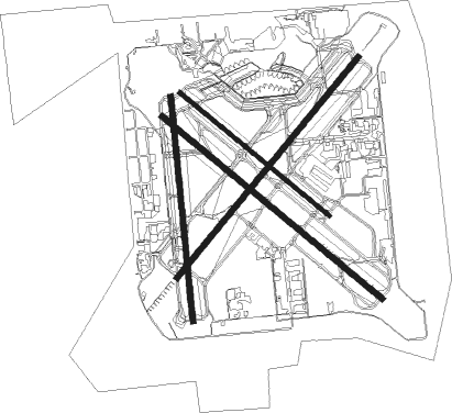
Runway info
Runway 4 / 22  | ||
| length | 2319m (7608ft) | |
| bearing | 48° / 228° | |
| width | 46m (151ft) | |
| surface | concrete | |
| blast zone | 60m (197ft) / 60m (197ft) | |
| Runway 13R / 31L | ||
| length | 2319m (7608ft) | |
| bearing | 130° / 310° | |
| width | 46m (151ft) | |
| surface | asphalt | |
| displ threshold | 315m (1033ft) / 0m (0ft) | |
| blast zone | 45m (148ft) / 45m (148ft) | |
| Runway 17 / 35 | ||
| length | 1835m (6020ft) | |
| bearing | 179° / 359° | |
| width | 46m (151ft) | |
| surface | asphalt | |
| blast zone | 60m (197ft) / 60m (197ft) | |
| Runway 13L / 31R | ||
| length | 1571m (5154ft) | |
| bearing | 130° / 310° | |
| width | 30m (98ft) | |
| surface | concrete | |
| blast zone | 45m (148ft) / 45m (148ft) | |
Nearby beacons
| code | identifier | dist | bearing | frequency |
|---|---|---|---|---|
| EFD | ELLINGTON (HOUSTON) TACAN | 6.6 | 108° | 109.40 |
| IAH | HUMBLE (HOUSTON) VORTAC | 19 | 348° | 116.60 |
| BVP | NIXIN (HOUSTON) NDB | 21.1 | 10° | 326 |
| MHF | TRINITY (SMITH POINT) VOR/DME | 28.3 | 101° | 113.60 |
| VUH | SCHOLES (GALVESTON) VOR/DME | 31.1 | 132° | 113 |
| DAS | DAISETTA VORTAC | 46.4 | 49° | 116.90 |
| CX | ALIBI (HOUSTON) NDB | 48.3 | 346° | 281 |
| TNV | NAVASOTA VOR/DME | 55.9 | 310° | 115.90 |
Departure and arrival routes
| Transition altitude | 18000ft |
| Transition level | 18000ft |
| SID end points | distance | outbound heading | |
|---|---|---|---|
| ALL | |||
| GIFFA1 | 104mi | 1° | |
| ELD1 | 253mi | 35° | |
| AEX3 | 278mi | 72° | |
| IDU1 | 254mi | 242° | |
| PSX2 | 166mi | 270° | |
| LOA4 | 218mi | 330° | |
| CRIED1 | 160mi | 340° | |
| RW04 | |||
| INDIE8 | 222mi | 29° | |
| LURIC8 | 218mi | 41° | |
| STRYA8 | 228mi | 67° | |
| ELOCO5 | 152mi | 90° | |
| HOODO7 | 93mi | 112° | |
| PEECE5 | 107mi | 142° | |
| PTRON7 | 140mi | 228° | |
| RETYR6 | 68mi | 277° | |
| STYCK8 | 160mi | 340° | |
| BLTWY7 | 105mi | 347° | |
| WYLSN8 | 113mi | 351° | |
| RW13 (ALL) | |||
| INDIE8 | 222mi | 29° | |
| LURIC8 | 218mi | 41° | |
| STRYA8 | 228mi | 67° | |
| ELOCO5 | 152mi | 90° | |
| HOODO7 | 93mi | 112° | |
| PEECE5 | 107mi | 142° | |
| PTRON7 | 140mi | 228° | |
| RETYR6 | 68mi | 277° | |
| STYCK8 | 160mi | 340° | |
| BLTWY7 | 105mi | 347° | |
| WYLSN8 | 113mi | 351° | |
| RW22 | |||
| INDIE8 | 222mi | 29° | |
| LURIC8 | 218mi | 41° | |
| STRYA8 | 228mi | 67° | |
| ELOCO5 | 152mi | 90° | |
| HOODO7 | 93mi | 112° | |
| PEECE5 | 107mi | 142° | |
| PTRON7 | 140mi | 228° | |
| RETYR6 | 68mi | 277° | |
| STYCK8 | 160mi | 340° | |
| BLTWY7 | 105mi | 347° | |
| WYLSN8 | 113mi | 351° | |
| RW31 (ALL) | |||
| INDIE8 | 222mi | 29° | |
| LURIC8 | 218mi | 41° | |
| STRYA8 | 228mi | 67° | |
| ELOCO5 | 152mi | 90° | |
| HOODO7 | 93mi | 112° | |
| PEECE5 | 107mi | 142° | |
| PTRON7 | 140mi | 228° | |
| RETYR6 | 68mi | 277° | |
| STYCK8 | 160mi | 340° | |
| BLTWY7 | 105mi | 347° | |
| WYLSN8 | 113mi | 351° | |
| STAR starting points | distance | inbound heading | |
|---|---|---|---|
| ALL | |||
| TSHRT1 | 46.5 | 68° | |
| SNIFY1 | 59.8 | 122° | |
| BLUBL4 | 66.3 | 123° | |
| OHIIO4 | 31.2 | 202° | |
| HUDZY4 | 36.8 | 226° | |
| RW04 | |||
| BELLR4 | 33.0 | 74° | |
| KIDDZ4 | 31.4 | 91° | |
| WAPPL6 | 13.5 | 200° | |
| CESAN4 | 45.4 | 259° | |
| BAYYY4 | 35.2 | 291° | |
| TKNIQ3 | 35.7 | 295° | |
| RW13 (ALL) | |||
| BELLR4 | 33.0 | 74° | |
| KIDDZ4 | 31.4 | 91° | |
| WAPPL6 | 13.5 | 200° | |
| CESAN4 | 45.4 | 259° | |
| BAYYY4 | 35.2 | 291° | |
| TKNIQ3 | 35.7 | 295° | |
| RW22 | |||
| BELLR4 | 33.0 | 74° | |
| KIDDZ4 | 31.4 | 91° | |
| WAPPL6 | 13.5 | 200° | |
| CESAN4 | 45.4 | 259° | |
| PUCKS4 | 35.2 | 291° | |
| TKNIQ3 | 35.7 | 295° | |
| RW31 (ALL) | |||
| BELLR4 | 33.0 | 74° | |
| KIDDZ4 | 31.4 | 91° | |
| WAPPL6 | 13.5 | 200° | |
| CESAN4 | 45.4 | 259° | |
| PUCKS4 | 35.2 | 291° | |
| TKNIQ3 | 35.7 | 295° | |
Instrument approach procedures
| runway | airway (heading) | route (dist, bearing) |
|---|---|---|
| RW04 | GEEEO (66°) | GEEEO 6000ft CARCO (9mi, 94°) 4000ft |
| RNAV | CARCO 4000ft ELREN (7mi, 48°) 2000ft ESAAY (3mi, 48°) 1500ft KHOU (5mi, 48°) 99ft (5681mi, 107°) 244ft RAYCI (5669mi, 287°) 2000ft RAYCI (turn) |
Holding patterns
| STAR name | hold at | type | turn | heading* | altitude | leg | speed limit |
|---|---|---|---|---|---|---|---|
| BAYYY4 | GEEAR | VHF | left | 92 (272)° | DME 10.0mi | ICAO rules | |
| BAYYY4 | KCEEE | VHF | left | 88 (268)° | DME 10.0mi | ICAO rules | |
| BAYYY4 | LEV | NDB | left | 103 (283)° | DME 10.0mi | ICAO rules | |
| BAYYY4 | SHLLL | VHF | left | 133 (313)° | DME 10.0mi | ICAO rules | |
| BELLR4 | ALIEF | VHF | right | 209 (29)° | DME 10.0mi | ICAO rules | |
| BELLR4 | AMMMO | VHF | right | 203 (23)° | DME 10.0mi | ICAO rules | |
| BELLR4 | BELLR | VHF | right | 206 (26)° | DME 10.0mi | ICAO rules | |
| BLUBL4 | ELLVR | VHF | right | 351 (171)° | 18000ft - 45000ft | 1.5min timed | ICAO rules |
| HUDZY4 | BRWCK | VHF | left | 55 (235)° | DME 20.0mi | ICAO rules | |
| HUDZY4 | WAPPL | VHF | left | 55 (235)° | DME 10.0mi | ICAO rules | |
| KIDDZ4 | CAASE | VHF | right | 332 (152)° | DME 10.0mi | ICAO rules | |
| KIDDZ4 | JAAES | VHF | left | 285 (105)° | DME 10.0mi | ICAO rules | |
| OHIIO4 | LYMBO | VHF | right | 71 (251)° | DME 20.0mi | ICAO rules | |
| OHIIO4 | ZEEKK | VHF | right | 46 (226)° | DME 10.0mi | ICAO rules | |
| PUCKS4 | GEEAR | VHF | left | 92 (272)° | DME 10.0mi | ICAO rules | |
| PUCKS4 | KCEEE | VHF | left | 88 (268)° | DME 10.0mi | ICAO rules | |
| PUCKS4 | LEV | NDB | left | 103 (283)° | DME 10.0mi | ICAO rules | |
| PUCKS4 | SHLLL | VHF | left | 133 (313)° | DME 10.0mi | ICAO rules | |
| SNIFY1 | ELLVR | VHF | right | 351 (171)° | 18000ft - 45000ft | 1.5min timed | ICAO rules |
| TKNIQ3 | TKNIQ | VHF | left | 91 (271)° | DME 10.0mi | ICAO rules | |
| TSHRT1 | ALIEF | VHF | right | 209 (29)° | DME 10.0mi | ICAO rules | |
| TSHRT1 | HYDRL | VHF | right | 209 (29)° | DME 10.0mi | ICAO rules | |
| WAPPL6 | BRWCK | VHF | left | 55 (235)° | DME 20.0mi | ICAO rules | |
| WAPPL6 | WAPPL | VHF | left | 55 (235)° | DME 10.0mi | ICAO rules | |
| *) magnetic outbound (inbound) holding course | |||||||
Disclaimer
The information on this website is not for real aviation. Use this data with the X-Plane flight simulator only! Data taken with kind consent from X-Plane 12 source code and data files. Content is subject to change without notice.