Hugoton - Hugoton Muni
Airport details
| Country | United States of America |
| State | Kansas |
| Region | K3 |
| Airspace | Kansas City Ctr |
| Municipality | Stevens County |
| Elevation | 3133ft (955m) |
| Timezone | GMT -6 |
| Coordinates | 37.16308, -101.37053 |
| Magnetic var | |
| Type | land |
| Available since | X-Plane v10.40 |
| ICAO code | KHQG |
| IATA code | n/a |
| FAA code | HQG |
Communication
| Hugoton Muni AWOS 3 | 118.600 |
| Hugoton Muni CTAF/UNICOM | 122.800 |
Nearby Points of Interest:
Wagon Bed Spring
-Hooker Woodframe Grain Elevator
-Grant County Courthouse District
-Morton County WPA Bridge
-Texas County Courthouse
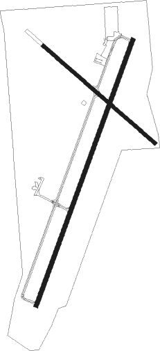
Runway info
Runway 2 / 20  | ||
| length | 1526m (5007ft) | |
| bearing | 30° / 210° | |
| width | 23m (75ft) | |
| surface | concrete | |
| Runway 13 / 31 | ||
| length | 801m (2628ft) | |
| bearing | 129° / 309° | |
| width | 18m (60ft) | |
| surface | asphalt | |
| displ threshold | 0m (0ft) / 62m (203ft) | |
Nearby beacons
| code | identifier | dist | bearing | frequency |
|---|---|---|---|---|
| HQG | HUGOTON NDB | 0.2 | 277° | 365 |
| LBL | LIBERAL VORTAC | 20.4 | 107° | 112.30 |
| LB | PANCK (LIBERAL) NDB | 23.1 | 116° | 383 |
| ULS | ULYSSES NDB | 26 | 0° | 395 |
| GUY | GUYMON NDB | 28.2 | 196° | 275 |
| GC | PIEVE (GARDEN CITY) NDB | 50.4 | 44° | 347 |
| PYX | PERRYTON NDB | 54.1 | 140° | 266 |
| GCK | GARDEN CITY VORTAC | 54.8 | 40° | 113.30 |
Instrument approach procedures
| runway | airway (heading) | route (dist, bearing) |
|---|---|---|
| RW02 | BRAKR (17°) | BRAKR OVAME (15mi, 6°) 5000ft |
| RW02 | LBL (287°) | LBL UBICI (21mi, 256°) 5000ft OVAME (5mi, 290°) 5000ft |
| RW02 | OVAME (30°) | OVAME 5000ft |
| RNAV | OVAME 5000ft WATRI (6mi, 30°) 5000ft KHQG (6mi, 30°) 3178ft (5948mi, 110°) 3383ft WAGIX (5942mi, 290°) 5000ft WAGIX (turn) | |
| RW20 | LBL (287°) | LBL ZATUX (19mi, 324°) 5000ft WAGIX (5mi, 290°) 5000ft |
| RW20 | UPIRE (148°) | UPIRE POYIL (9mi, 105°) 5000ft WAGIX (5mi, 110°) 5000ft |
| RW20 | WAGIX (210°) | WAGIX 5000ft |
| RNAV | WAGIX 5000ft YAPUS (6mi, 210°) 5000ft KHQG (6mi, 210°) 3175ft (5948mi, 110°) 3382ft OVAME (5955mi, 290°) 5000ft OVAME (turn) |
Disclaimer
The information on this website is not for real aviation. Use this data with the X-Plane flight simulator only! Data taken with kind consent from X-Plane 12 source code and data files. Content is subject to change without notice.