Harrisburg - Harrisburgh Raleigh
Airport details
| Country | United States of America |
| State | Illinois |
| Region | K5 |
| Airspace | Kansas City Ctr |
| Municipality | Saline County |
| Elevation | 395ft (120m) |
| Timezone | GMT -6 |
| Coordinates | 37.81126, -88.55026 |
| Magnetic var | |
| Type | land |
| Available since | X-Plane v10.40 |
| ICAO code | KHSB |
| IATA code | HSB |
| FAA code | HSB |
Communication
| Harrisburgh Raleigh AWOS 3 | 135.925 |
| Harrisburgh Raleigh CTAF/UNICOM | 122.800 |
Nearby Points of Interest:
Harrisburg City Hall
-Tunnel Hill State Trail
-Eldorado City Hall
-Saline County Poor Farm
-Crenshaw House
-Illinois Salines
-Chalon Guard and Emma Blades Cloud House
-Cloud State Bank
-Aaron G. Cloud House
-Lusk Creek Canyon
-Bell Smith Springs
-West Frankfort City Hall
-Goddard Chapel
-Williamson County Jail
-Willis Allen House
-Camp Mather-Camp Logan
-Ed M. Stotlar House
-Marion Veterans Affairs Medical Center
-Franklin County Jail
-Robert and John McKee Peeples Houses
-Duffy Site
-Carmi Chapter House
-Orr-Herl Mound and Village Site
-L. Haas Store
-Robinson-Stewart House
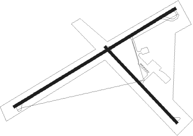
Runway info
Runway 14 / 32  | ||
| length | 843m (2766ft) | |
| bearing | 134° / 314° | |
| width | 23m (75ft) | |
| surface | asphalt | |
| Runway 6 / 24 | ||
| length | 1529m (5016ft) | |
| bearing | 68° / 248° | |
| width | 23m (75ft) | |
| surface | asphalt | |
Nearby beacons
| code | identifier | dist | bearing | frequency |
|---|---|---|---|---|
| MW | JONNY (MARION) NDB | 20 | 274° | 382 |
| MWA | DME | 22.1 | 263° | 110.40 |
| MD | CABBI (CARBONDALE-MURPHYSBORO) NDB | 33.1 | 275° | 388 |
| FWC | WAYNE CO (FAIRFIELD) NDB | 34.8 | 14° | 257 |
| VNN | VERNON DME | 35.2 | 335° | 113.80 |
| PXV | POCKET CITY (EVANSVILLE) VORTAC | 38 | 82° | 113.30 |
| SAM | SAMSVILLE VOR/DME | 46 | 35° | 116.60 |
| ENL | CENTRALIA VORTAC | 46.5 | 315° | 115 |
| CNG | CUNNINGHAM (PADUCAH) VOR/DME | 50.1 | 200° | 113.10 |
| CIR | CAIRO NDB | 55.3 | 222° | 397 |
| OLY | OLNEY NDB | 57.3 | 23° | 272 |
| LWV | DME | 72.8 | 45° | 108.80 |
Instrument approach procedures
| runway | airway (heading) | route (dist, bearing) |
|---|---|---|
| RW06 | FEBIB (47°) | FEBIB 2700ft JATUS (5mi, 327°) 2700ft |
| RW06 | JATUS (68°) | JATUS 2700ft |
| RW06 | VINUC (87°) | VINUC 2700ft JATUS (5mi, 147°) 2700ft |
| RNAV | JATUS 2700ft LUSIY (6mi, 68°) 2100ft CIKAB (3mi, 68°) 1020ft KHSB (2mi, 70°) 422ft JIVSO (11mi, 68°) 2000ft JIVSO (turn) | |
| RW24 | IPEYU (267°) | IPEYU 2000ft JIVSO (5mi, 328°) 2000ft |
| RW24 | JIVSO (248°) | JIVSO 6000ft JIVSO (turn) 2000ft |
| RW24 | TIYUP (226°) | TIYUP JIVSO (5mi, 147°) 2000ft |
| RNAV | JIVSO 2000ft LAGLE (6mi, 248°) 2000ft FASKI (3mi, 248°) 1020ft KHSB (2mi, 246°) 431ft (5336mi, 113°) 697ft JATUS (5347mi, 293°) 2700ft JATUS (turn) |
Disclaimer
The information on this website is not for real aviation. Use this data with the X-Plane flight simulator only! Data taken with kind consent from X-Plane 12 source code and data files. Content is subject to change without notice.