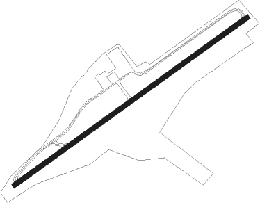
Hot Springs - Ingalls Field
Airport details
| Country | United States of America |
| State | Virginia |
| Region | K6 |
| Airspace | Washington Ctr |
| Municipality | Bath County |
| Elevation | 3791ft (1155m) |
| Timezone | GMT -5 |
| Coordinates | 37.95144, -79.83389 |
| Magnetic var | |
| Type | land |
| Available since | X-Plane v10.40 |
| ICAO code | KHSP |
| IATA code | HSP |
| FAA code | HSP |
Communication
| Ingalls Field AWOS 3 | 118.800 |
| Ingalls Field CTAF/UNICOM | 123.000 |
Approach frequencies
| ILS-cat-I | RW25 | 108.7 | 18.00mi |
| 3° GS | RW25 | 108.7 | 18.00mi |
Nearby Points of Interest:
Ashwood School
-Barton Lodge
-The Yard (Hot Springs, Virginia)
-Mustoe House
-Old Stone House
-Garth Newel
-Oakley Farm
-Massie House
-Warm Springs Mill
-Homestead Dairy Barns
-Jefferson Pools
-Clifton Forge Residential Historic District
-Clifton Forge Commercial Historic District
-Clifton Furnace
-Hidden Valley (Bacova, Virginia)
-Camp Alkulana
-Callie Furnace
-Millboro School
-Luke Mountain Historic District
-Fudge House
-Wood Hall (Callaghan, Virginia)
-John Moore House (Lexington, Virginia)
-Rosedale Historic District
-Mountain View Farm (Lexington, Virginia)
-Watoga State Park
Runway info
| Runway 7 / 25 | ||
| length | 1708m (5604ft) | |
| bearing | 64° / 244° | |
| width | 30m (98ft) | |
| surface | asphalt | |
Nearby beacons
| code | identifier | dist | bearing | frequency |
|---|---|---|---|---|
| LWB | DME | 26.9 | 261° | 116.05 |
| LW | BUSHI (LEWISBURG) NDB | 31.7 | 255° | 346 |
| MOL | MONTEBELLO VOR/DME | 34.5 | 94° | 115.30 |
| ODR | WOODRUM (ROANOKE) VOR | 38.2 | 193° | 114.90 |
| ROA | ROANOKE VOR/DME | 38.2 | 201° | 109.40 |
| SH | STAUT(STAUNTON-WAYNESBORO-HARR NDB | 44 | 74° | 375 |
| VIT | VINTON (ROANOKE) NDB | 44.9 | 184° | 277 |
| RNL | RAINELLE VOR | 46 | 271° | 116.60 |
| LY | BOJAR (LYNCHBURG) NDB | 50 | 139° | 385 |
| LYH | LYNCHBURG VOR/DME | 50.5 | 139° | 109.20 |
| TEC | TECH (BLACKSBURG) NDB | 52.2 | 217° | 368 |
| RQY | RANDOLPH CO. (ELKINS) NDB | 56.6 | 358° | 284 |
| EKN | ELKINS VORTAC | 59.1 | 345° | 114.20 |
| PSK | PULASKI (DUBLIN) VORTAC | 66.6 | 226° | 116.80 |
Instrument approach procedures
| runway | airway (heading) | route (dist, bearing) |
|---|---|---|
| RW07 | COVEY (36°) | COVEY WUWAP (14mi, 5°) 6000ft |
| RW07 | FRETT (91°) | FRETT WUWAP (19mi, 107°) 6000ft |
| RNAV | WUWAP 6000ft HOSFE (6mi, 64°) 5700ft KHSP (6mi, 64°) 3850ft AHLER (11mi, 64°) 6000ft AHLER (turn) | |
| RW25 | AHLER (244°) | AHLER 6000ft |
| RW25 | BOOME (275°) | BOOME AHLER (13mi, 300°) 6000ft |
| RW25 | HOBOS (339°) | HOBOS DAYYU (17mi, 31°) 7000ft AHLER (5mi, 323°) 6000ft |
| RW25 | NATTS (89°) | NATTS GOBRE (21mi, 66°) 7000ft AHLER (5mi, 143°) 6000ft |
| RNAV | AHLER 6000ft AHAFY (6mi, 244°) 5100ft KHSP (4mi, 244°) 3822ft CEXAS (2mi, 244°) NATTS (10mi, 273°) 6000ft NATTS (turn) |
Disclaimer
The information on this website is not for real aviation. Use this data with the X-Plane flight simulator only! Data taken with kind consent from X-Plane 12 source code and data files. Content is subject to change without notice.
