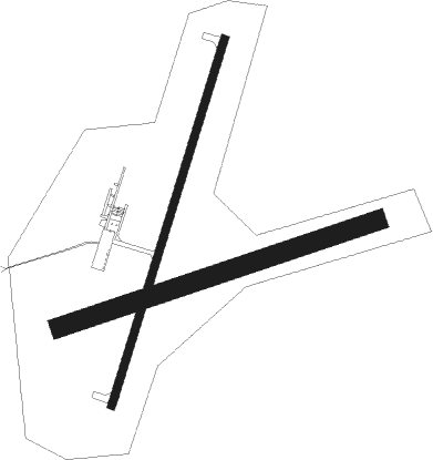
Hot Springs - Hot Springs Muni
Airport details
| Country | United States of America |
| State | South Dakota |
| Region | K3 |
| Airspace | Denver Ctr |
| Municipality | Fall River County |
| Elevation | 3145ft (959m) |
| Timezone | GMT -7 |
| Coordinates | 43.36831, -103.38828 |
| Magnetic var | |
| Type | land |
| Available since | X-Plane v10.40 |
| ICAO code | KHSR |
| IATA code | n/a |
| FAA code | HSR |
Communication
| Hot Springs Muni CTAF/UNICOM | 122.800 |
Nearby Points of Interest:
Governor Leslie Jensen House
-Mammoth Site, Hot Springs
-Hot Springs High School
-Phillip Wesch House
-Buffalo Gap Historic Commercial District
-Wind Cave National Park Administrative and Utility Area Historic District
-Beaver Creek Rockshelter
-Beaver Creek Bridge
-Pig Tail Bridge
-Chilson Bridge
-Garlock Building
-Peter Norbeck Summer House
-Needles
Nearby beacons
| code | identifier | dist | bearing | frequency |
|---|---|---|---|---|
| HIN | WHITNEY (CHADRON) NDB | 34.8 | 151° | 275 |
| CD | DAWES (CHADRON) NDB | 37.9 | 161° | 362 |
| RAP | RAPID CITY VORTAC | 39.9 | 32° | 112.30 |
| RCA | ELLSWORTH (RAPID CITY) TACAN | 47.9 | 20° | 108.80 |
| TST | TOADSTOOL VOR/DME | 48.7 | 175° | 113.40 |
| ECS | NEWCASTLE VOR | 50.4 | 299° | 108.20 |
Departure and arrival routes
| Transition altitude | 18000ft |
| Transition level | 18000ft |
| SID end points | distance | outbound heading | |
|---|---|---|---|
| RW01 | |||
| HSR2 | 40mi | 32° | |
| TST2 | 49mi | 175° | |
| RW19 | |||
| HSR2 | 40mi | 32° | |
| TST2 | 49mi | 175° | |
Instrument approach procedures
| runway | airway (heading) | route (dist, bearing) |
|---|---|---|
| RW01 | WOTEP (29°) | WOTEP 6600ft |
| RNAV | WOTEP 6600ft ZEKEB (8mi, 28°) 5000ft LODHY (3mi, 28°) 4000ft KHSR (3mi, 30°) 3190ft (5987mi, 113°) 3900ft WOTEP (5994mi, 293°) 6600ft WOTEP (turn) | |
| RW19 | YIVSU (208°) | YIVSU 6800ft |
| RNAV | YIVSU 6800ft WIPDO (8mi, 209°) 5200ft OSLUW (4mi, 209°) 4040ft KHSR (3mi, 207°) 3182ft (5987mi, 113°) 3550ft WOTEP (5994mi, 293°) 6600ft WOTEP (turn) |
Disclaimer
The information on this website is not for real aviation. Use this data with the X-Plane flight simulator only! Data taken with kind consent from X-Plane 12 source code and data files. Content is subject to change without notice.

