San Marcos - San Marcos Rgnl
Airport details
| Country | United States of America |
| State | Texas |
| Region | K4 |
| Airspace | Houston Oceanic Ctr |
| Municipality | San Marcos |
| Elevation | 594ft (181m) |
| Timezone | GMT -6 |
| Coordinates | 29.89275, -97.86300 |
| Magnetic var | |
| Type | land |
| Available since | X-Plane v10.40 |
| ICAO code | KHYI |
| IATA code | n/a |
| FAA code | HYI |
Communication
| San Marcos Rgnl ATIS | 120.825 |
| San Marcos Rgnl Clearance DEL | 121.350 |
| San Marcos Rgnl San Marcos Ground | 120.125 |
| San Marcos Rgnl San Marcos Tower | 126.825 |
| San Marcos Rgnl AUSTIN Approach/Departure | 119.000 |
Approach frequencies
| ILS-cat-I | RW13 | 108.7 | 18.00mi |
| 3° GS | RW13 | 108.7 | 18.00mi |
Nearby Points of Interest:
Old Main
-Farmers Union Gin Company
-Katherine Anne Porter House
-M. A. Withers House
-Caldwell County Courthouse Historic District
-Winters-Wimberley House
-Gruene Historic District
-Gruene Family Home
-Lindheimer House
-Carl W. A. Groos House
-Comal County Courthouse
-Comal Power Plant
-Smith Rock Shelter
-Dripping Springs
-Dr. Joseph M. and Sarah Pound Farmstead
-Louis and Mathilde Reuter House
-Swedish Hill Historic District
-West Line Historic District
-Shadow Lawn Historic District
-Old West Austin Historic District
-Willow-Spence Streets Historic District
-J. P. Schneider Store
-Austin Central Fire Station 1
-West Fifth Street Bridge at Shoal Creek
-Congress Avenue Historic District
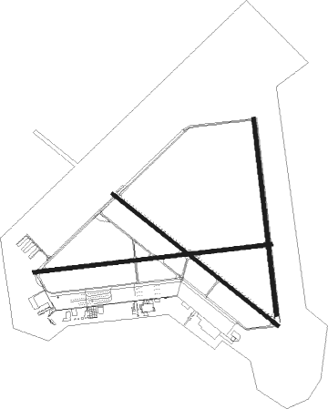
Runway info
Runway 13 / 31  | ||
| length | 1709m (5607ft) | |
| bearing | 129° / 309° | |
| width | 30m (100ft) | |
| surface | asphalt | |
| Runway 17 / 35 | ||
| length | 1595m (5233ft) | |
| bearing | 178° / 358° | |
| width | 30m (100ft) | |
| surface | asphalt | |
| blast zone | 0m (0ft) / 70m (230ft) | |
| Runway 8 / 26 | ||
| length | 1929m (6329ft) | |
| bearing | 88° / 268° | |
| width | 30m (100ft) | |
| surface | asphalt | |
Nearby beacons
| code | identifier | dist | bearing | frequency |
|---|---|---|---|---|
| RU | GARYS (AUSTIN) NDB | 5.9 | 307° | 272 |
| DHK | RANDOLPH TACAN | 30 | 229° | 109.90 |
| RND | RANDOLPH VORTAC | 31.4 | 228° | 112.30 |
| CWK | CENTEX VORTAC | 33.9 | 34° | 112.80 |
| SAT | SAN ANTONIO VORTAC | 34.5 | 247° | 116.80 |
| AN | ALAMO (SAN ANTONIO) NDB | 40.6 | 248° | 368 |
| STV | STONEWALL VORTAC | 47.6 | 290° | 113.80 |
| KSY | KELLY (SAN ANTONIO) TACAN | 48 | 235° | 112 |
| SSF | STINSON (SAN ANTONIO) VOR | 48.6 | 222° | 108.40 |
| LLO | LLANO VORTAC | 72.3 | 314° | 108.20 |
Departure and arrival routes
| Transition altitude | 18000ft |
| Transition level | 18000ft |
| SID end points | distance | outbound heading | |
|---|---|---|---|
| RW08 | |||
| SAYBR3 | 77mi | 37° | |
| ILEXY3 | 97mi | 78° | |
| BNDIA3 | 35mi | 247° | |
| MUCKY3 | 61mi | 298° | |
| AEROZ2 | 161mi | 300° | |
| ELOEL3 | 80mi | 352° | |
| RW13 | |||
| SAYBR3 | 77mi | 37° | |
| ILEXY3 | 97mi | 78° | |
| BNDIA3 | 35mi | 247° | |
| MUCKY3 | 61mi | 298° | |
| AEROZ2 | 161mi | 300° | |
| ELOEL3 | 80mi | 352° | |
| RW17 | |||
| SAYBR3 | 77mi | 37° | |
| ILEXY3 | 97mi | 78° | |
| BNDIA3 | 35mi | 247° | |
| MUCKY3 | 61mi | 298° | |
| AEROZ2 | 161mi | 300° | |
| ELOEL3 | 80mi | 352° | |
| RW26 | |||
| SAYBR3 | 77mi | 37° | |
| ILEXY3 | 97mi | 78° | |
| BNDIA3 | 35mi | 247° | |
| MUCKY3 | 61mi | 298° | |
| AEROZ2 | 161mi | 300° | |
| ELOEL3 | 80mi | 352° | |
| RW31 | |||
| SAYBR3 | 77mi | 37° | |
| ILEXY3 | 97mi | 78° | |
| BNDIA3 | 35mi | 247° | |
| MUCKY3 | 61mi | 298° | |
| AEROZ2 | 161mi | 300° | |
| ELOEL3 | 80mi | 352° | |
| RW35 | |||
| SAYBR3 | 77mi | 37° | |
| ILEXY3 | 97mi | 78° | |
| BNDIA3 | 35mi | 247° | |
| MUCKY3 | 61mi | 298° | |
| AEROZ2 | 161mi | 300° | |
| ELOEL3 | 80mi | 352° | |
| STAR starting points | distance | inbound heading | |
|---|---|---|---|
| ALL | |||
| BLEWE4 | 85.9 | 206° | |
| GABOO1 | 68.0 | 208° | |
| BITER9, POTRR1 | 52.4 | 261° | |
Instrument approach procedures
| runway | airway (heading) | route (dist, bearing) |
|---|---|---|
| RW08 | RAJRY (88°) | RAJRY 3000ft |
| RNAV | RAJRY 3000ft KEDCE (7mi, 88°) 2400ft NUHOS (2mi, 88°) 1620ft KHYI (4mi, 88°) 643ft (5814mi, 107°) 839ft QIMIB (5802mi, 287°) 3000ft QIMIB (turn) | |
| RW13 | ORALE (129°) | ORALE 3500ft |
| RNAV | ORALE 3500ft JISGO (7mi, 129°) 2700ft YOYTU (3mi, 129°) 1700ft KHYI (4mi, 128°) 650ft (5814mi, 107°) 793ft HODAL (5806mi, 287°) 3000ft HODAL (turn) | |
| RW17 | PUKIY (179°) | PUKIY 3100ft |
| RNAV | PUKIY 3100ft YADUK (7mi, 178°) 2600ft KUXZE (3mi, 178°) 1700ft KHYI (4mi, 183°) 650ft (5814mi, 107°) 960ft CILAK (5814mi, 287°) 3100ft CILAK (turn) | |
| RW26 | QIMIB (268°) | QIMIB 3000ft |
| RNAV | QIMIB 3000ft NAKIC (7mi, 268°) 2000ft TUROC (2mi, 268°) 1400ft KHYI (3mi, 269°) 635ft (5814mi, 107°) 830ft RAJRY (5828mi, 287°) 3000ft RAJRY (turn) | |
| RW31 | HODAL (309°) | HODAL 3000ft |
| RNAV | HODAL 3000ft RUYOK (7mi, 309°) 2000ft TONXU (2mi, 309°) 1420ft KHYI (3mi, 310°) 633ft (5814mi, 107°) 850ft ORALE (5824mi, 287°) 3500ft ORALE (turn) | |
| RW35 | CILAK (356°) | CILAK 3100ft |
| RNAV | CILAK 3100ft UDOTE (7mi, 358°) 2000ft MOKXO (2mi, 358°) 1420ft KHYI (3mi, 351°) 630ft (5814mi, 107°) 825ft PUKIY (5814mi, 287°) 3100ft PUKIY (turn) |
Holding patterns
| STAR name | hold at | type | turn | heading* | altitude | leg | speed limit |
|---|---|---|---|---|---|---|---|
| BITER9 | WLEEE | VHF | left | 101 (281)° | 1.0min timed | ICAO rules | |
| BLEWE4 | SEWZY | VHF | left | 12 (192)° | 1.0min timed | ICAO rules | |
| *) magnetic outbound (inbound) holding course | |||||||
Disclaimer
The information on this website is not for real aviation. Use this data with the X-Plane flight simulator only! Data taken with kind consent from X-Plane 12 source code and data files. Content is subject to change without notice.