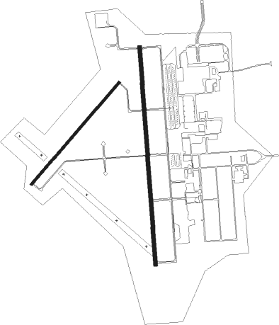
Independence - Independence Muni
Airport details
| Country | United States of America |
| State | Kansas |
| Region | K3 |
| Airspace | Kansas City Ctr |
| Municipality | Independence |
| Elevation | 825ft (251m) |
| Timezone | GMT -5 |
| Coordinates | 37.15792, -95.77895 |
| Magnetic var | |
| Type | land |
| Available since | X-Plane v10.40 |
| ICAO code | KIDP |
| IATA code | IDP |
| FAA code | IDP |
Communication
| INDEPENDENCE MUNI AWOS 3 | 118.525 |
| INDEPENDENCE MUNI CTAF/UNICOM | 123.050 |
| INDEPENDENCE MUNI Clearance DEL | 121.650 |
| INDEPENDENCE MUNI CTAF (No Tower) | 123.050 |
| INDEPENDENCE MUNI KANSAS CITY CNTR | 132.900 |
Approach frequencies
| ILS-cat-I | RW35 | 110.7 | 18.00mi |
| 3° GS | RW35 | 110.7 | 18.00mi |
Nearby Points of Interest:
Union Implement and Hardware Building-Masonic Temple
-Booth Theater
-Onion Creek Bridge (Coffeyville, Kansas)
-Elk Falls Pratt Truss Bridge
-Old Washington County Courthouse
-LaQuinta
-Diamond Point School
Nearby beacons
| code | identifier | dist | bearing | frequency |
|---|---|---|---|---|
| BV | DEWIE (BARTLESVILLE) NDB | 22.1 | 216° | 201 |
| BVO | BARTLESVILLE VOR/DME | 22.5 | 217° | 117.90 |
| OSW | OSWEGO VOR/DME | 27.5 | 90° | 117.60 |
| CNU | CHANUTE VOR/DME | 29.4 | 22° | 109.20 |
| TUL | TULSA VORTAC | 57.7 | 181° | 114.40 |
Instrument approach procedures
| runway | airway (heading) | route (dist, bearing) |
|---|---|---|
| RW17 | UYUPU (181°) | UYUPU 2600ft |
| RW17 | WENIX (217°) | WENIX UYUPU (7mi, 270°) 2600ft |
| RNAV | UYUPU 2600ft PUWES (6mi, 180°) 2500ft FLEYS (3mi, 180°) 1700ft KIDP (3mi, 183°) 876ft (5682mi, 111°) 1021ft USUCE (5682mi, 291°) 2600ft USUCE (turn) | |
| RW35 | BVO (37°) | BVO WARTO (9mi, 44°) 2600ft USUCE (6mi, 89°) 2600ft |
| RW35 | EJYAR (320°) | EJYAR USUCE (9mi, 279°) 2600ft |
| RW35 | USUCE (360°) | USUCE 2600ft |
| RNAV | USUCE 2600ft ZIMID (6mi, 0°) 2600ft YIRGU (3mi, 0°) 1740ft KIDP (3mi, 358°) 861ft (5682mi, 111°) 1021ft UYUPU (5681mi, 291°) 2600ft UYUPU (turn) |
Disclaimer
The information on this website is not for real aviation. Use this data with the X-Plane flight simulator only! Data taken with kind consent from X-Plane 12 source code and data files. Content is subject to change without notice.

