Chicago - Lansing Muni
Airport details
| Country | United States of America |
| State | Illinois |
| Region | K5 |
| Airspace | Chicago Ctr |
| Municipality | Lynwood |
| Elevation | 620ft (189m) |
| Timezone | GMT -6 |
| Coordinates | 41.53492, -87.52953 |
| Magnetic var | |
| Type | land |
| Available since | X-Plane v10.40 |
| ICAO code | KIGQ |
| IATA code | IGQ |
| FAA code | IGQ |
Communication
| LANSING MUNI AWOS 3 | 119.275 |
| LANSING MUNI CTAF/UNICOM | 122.700 |
| LANSING MUNI TOWER | 128.800 |
| LANSING MUNI CHICAGO Approach/Departure | 128.200 |
Approach frequencies
| LOC | RW36 | 109.15 | 18.00mi |
Nearby Points of Interest:
Stallbohm Barn-Kaske House
-Ibach House
-Meyer's Castle
-George John Wolf House
-Roselawn-Forest Heights Historic District
-Morse Dell Plain House and Garden
-Northern States Life Insurance Company
-Griffith Grand Trunk Depot
-E.J. and E. Griffith Interlocking Tower
-State Bank of Hammond Building
-Hohman Avenue Commercial Historic District
-State Street Commercial Historic District
-Flat Iron Building
-Francis P. Keilman House
-Indiana Harbor Public Library
-Pacesetter Gardens Historic District
-Combs Addition Historic District
-Gensburg-Markham Prairie
-Barney Sablotney House
-Morningside Historic District
-Jefferson Street Historic District
-Eskilson Historic District
-Whiting Memorial Community House
-Lincoln Street Historic District
-Wilbur Wynant House
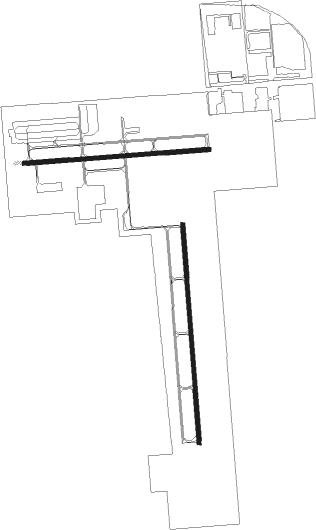
Runway info
Runway 18 / 36  | ||
| length | 1222m (4009ft) | |
| bearing | 180° / 0° | |
| width | 23m (75ft) | |
| surface | asphalt | |
| Runway 9 / 27 | ||
| length | 1035m (3396ft) | |
| bearing | 90° / 270° | |
| width | 23m (74ft) | |
| surface | asphalt | |
| blast zone | 63m (207ft) / 0m (0ft) | |
Nearby beacons
| code | identifier | dist | bearing | frequency |
|---|---|---|---|---|
| CGT | CHICAGO HEIGHTS VORTAC | 2.4 | 239° | 114.20 |
| GY | GARIE (GARY) NDB | 9.3 | 80° | 236 |
| MX | KEDZI (CHICAGO) NDB | 14.3 | 322° | 248 |
| EON | PEOTONE VORTAC | 19.8 | 225° | 113.20 |
| VP | SEDLY (VALPARAISO) NDB | 29.7 | 97° | 212 |
| IKK | DME | 31.2 | 215° | 111.60 |
| GCO | DME | 32.2 | 321° | 108.25 |
| IK | LUKOW (KANKAKEE) NDB | 35.3 | 216° | 272 |
| JOT | JOLIET VOR/DME | 35.4 | 271° | 112.30 |
| OXI | KNOX VOR/DME | 41.6 | 104° | 115.60 |
| DPA | DUPAGE (CHICAGO) VOR/DME | 42.5 | 293° | 108.40 |
| OBK | NORTHBROOK VOR/DME | 45.3 | 328° | 113 |
| DTG | DWIGHT NDB | 47.4 | 246° | 344 |
| UG | WAUKE (CHICAGO/WAUKEGAN) NDB | 57 | 344° | 379 |
| BVT | BOILER (LAFAYETTE) VORTAC | 62.3 | 155° | 115.10 |
| RBS | ROBERTS VOR/DME | 64 | 214° | 116.80 |
Departure and arrival routes
| Transition altitude | 18000ft |
| Transition level | 18000ft |
| STAR starting points | distance | inbound heading | |
|---|---|---|---|
| ALL | |||
| GSH7 | 67.5 | 270° | |
| LUCIT2 | 18.7 | 341° | |
Instrument approach procedures
| runway | airway (heading) | route (dist, bearing) |
|---|---|---|
| RW09 | EON (45°) | EON UYELO (16mi, 6°) 2400ft |
| RW09 | JOT (91°) | JOT UYELO (25mi, 91°) 2400ft |
| RW09 | UYELO (91°) | UYELO 2400ft |
| RNAV | UYELO 2400ft HEFER (5mi, 90°) 2300ft KOGEC (3mi, 90°) 1320ft KIGQ (2mi, 95°) 655ft (5294mi, 115°) 1020ft UYELO (5305mi, 295°) 2400ft UYELO (turn) | |
| RW27 | HALIE (273°) | HALIE COOTE (7mi, 279°) 2300ft |
| RW27 | HARRT (211°) | HARRT BIZZE (10mi, 154°) 2300ft COOTE (5mi, 180°) 2300ft |
| RW27 | LUCIT (341°) | LUCIT WYZZE (14mi, 28°) 2800ft COOTE (5mi, 0°) 2300ft |
| RNAV | COOTE 2300ft CHIPR (5mi, 270°) 2200ft KIGQ (5mi, 268°) 657ft (5294mi, 115°) 1016ft UYELO (5305mi, 295°) 2400ft UYELO (turn) | |
| RW36 | EON (45°) | EON TOGOC (13mi, 72°) 2300ft |
| RW36 | LUCIT (341°) | LUCIT TOGOC (9mi, 320°) 2300ft |
| RW36 | TOGOC (360°) | TOGOC 2300ft |
| RNAV | TOGOC 2300ft WOKLA (5mi, 0°) 2300ft KIGQ (6mi, 359°) 659ft (5294mi, 115°) 1020ft TOGOC (5294mi, 295°) 2300ft TOGOC (turn) |
Holding patterns
| STAR name | hold at | type | turn | heading* | altitude | leg | speed limit |
|---|---|---|---|---|---|---|---|
| GSH7 | GSH | NDB | left | 92 (272)° | 1.0min timed | ICAO rules | |
| GSH7 | HALIE | VHF | left | 87 (267)° | 1.0min timed | ICAO rules | |
| GSH7 | IROCK | VHF | right | 87 (267)° | 1.0min timed | ICAO rules | |
| *) magnetic outbound (inbound) holding course | |||||||
Disclaimer
The information on this website is not for real aviation. Use this data with the X-Plane flight simulator only! Data taken with kind consent from X-Plane 12 source code and data files. Content is subject to change without notice.