Wilmington - New Castle
Airport details
| Country | United States of America |
| State | Delaware |
| Region | K6 |
| Airspace | Washington Ctr |
| Municipality | New Castle County |
| Elevation | 79ft (24m) |
| Timezone | GMT -5 |
| Coordinates | 39.67872, -75.60664 |
| Magnetic var | |
| Type | land |
| Available since | X-Plane v10.40 |
| ICAO code | KILG |
| IATA code | ILG |
| FAA code | ILG |
Communication
| New Castle ATIS | 123.950 |
| New Castle CTAF | 126.000 |
| New Castle UNICOM | 122.950 |
| New Castle Clearance DEL | 119.950 |
| New Castle Ground Control | 121.700 |
| New Castle WILMINGTON Tower | 126.000 |
| New Castle PHILADELPHIA Approach/Departure | 118.350 |
Approach frequencies
| ILS-cat-I | RW01 | 110.3 | 18.00mi |
| 3° GS | RW01 | 110.3 | 18.00mi |
Nearby Points of Interest:
The Hermitage
-Newport Railroad Station
-Lewis Weldin House
-Killgore Hall
-Joseph Killgore House
-New Castle Historic District
-Lobdell Estate, Minquadale Home
-Read House and Garden
-State of Pennsylvania
-Greenbank Historic Area
-Wilmington Rail Viaduct
-Philips-Thompson Buildings
-Charles Schagrin Building
-Louis McLane House
-Robert Ferguson House
-Charles Gray Printing Shop
-Finn's Point Rear Range Light
-Dr. John A. Brown House
-Torbert Street Livery Stables
-Kingswood Methodist Episcopal Church
-Continental Army Encampment Site
-Augustine Paper Mill
-Rockwood Museum and Park
-Eleutherian Mills
-State Theater
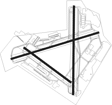
Runway info
Runway 9 / 27  | ||
| length | 2218m (7277ft) | |
| bearing | 80° / 260° | |
| width | 46m (150ft) | |
| surface | asphalt | |
| blast zone | 61m (200ft) / 61m (200ft) | |
| Runway 1 / 19 | ||
| length | 2140m (7021ft) | |
| bearing | 7° / 187° | |
| width | 46m (150ft) | |
| surface | asphalt | |
| blast zone | 183m (600ft) / 31m (102ft) | |
| Runway 14 / 32 | ||
| length | 1404m (4606ft) | |
| bearing | 124° / 304° | |
| width | 46m (150ft) | |
| surface | asphalt | |
Nearby beacons
| code | identifier | dist | bearing | frequency |
|---|---|---|---|---|
| DQO | DUPONT (WILMINGTON) VORTAC | 0 | 218° | 114 |
| IL | HADIN (WILMINGTON) NDB | 5.8 | 184° | 248 |
| OOD | WOODSTOWN VORTAC | 14.2 | 98° | 112.80 |
| MXE | MODENA VORTAC | 14.6 | 345° | 113.20 |
| RNB | RAINBOW (MILLVILLE) NDB | 26.8 | 119° | 363 |
| ENO | SMYRNA (KENTON) VORTAC | 27.1 | 169° | 111.40 |
| ING | AMBLER NDB | 30.6 | 36° | 275 |
| VCN | CEDAR LAKE (MILLVILLE) VOR/DME | 30.7 | 102° | 115.20 |
| PTW | POTTSTOWN VORTAC | 32.7 | 5° | 116.50 |
| DOV | DOVER TACAN | 33.4 | 166° | 110 |
| LRP | LANCASTER VOR/DME | 41.1 | 303° | 117.30 |
| MTN | MARTIN (BALTIMORE) TACAN | 42.7 | 247° | 134.10 |
| ARD | YARDLEY VOR/DME | 47.1 | 51° | 108.20 |
| SIE | SEA ISLE VORTAC | 51.2 | 126° | 114.80 |
| ETX | EAST TEXAS VOR/DME | 54.3 | 355° | 110.20 |
| ATR | WATERLOO VOR/DME | 55.3 | 156° | 112.60 |
| BZJ | BELLGROVE (INDIANTOWN GAP) NDB | 62.9 | 309° | 328 |
| SBJ | SOLBERG VOR/DME | 67.2 | 44° | 112.90 |
| RAV | RAVINE VORTAC | 69.5 | 311° | 114.60 |
Departure and arrival routes
| Transition altitude | 18000ft |
| Transition level | 18000ft |
| STAR starting points | distance | inbound heading | |
|---|---|---|---|
| ALL | |||
| BUNTS2 | 77.0 | 113° | |
| JIIMS3, VCN9 | 30.7 | 282° | |
| ARLFT2 | 27.1 | 349° | |
Instrument approach procedures
| runway | airway (heading) | route (dist, bearing) |
|---|---|---|
| RW01 | ODESA (50°) | ODESA COTMA (9mi, 94°) 2000ft |
| RW01 | OOD (278°) | OOD FOMOB (14mi, 232°) 2000ft COTMA (5mi, 274°) 2000ft |
| RNAV | COTMA 2000ft FESER (6mi, 7°) 1900ft CIROM (3mi, 7°) 960ft KILG (3mi, 2°) 127ft CUBBE (6mi, 9°) TENPY (7mi, 258°) ELUDE (6mi, 210°) 2000ft ELUDE (turn) | |
| RW09 | MXE (165°) | MXE ESTOO (15mi, 226°) 2100ft AWINN (5mi, 164°) 2000ft |
| RW09 | OOD (278°) | OOD DREFF (25mi, 261°) 2100ft AWINN (5mi, 344°) 2000ft |
| RNAV | AWINN 2000ft BATRE (6mi, 80°) 1700ft KILG (5mi, 81°) 135ft GUSTE (6mi, 80°) OOD (9mi, 109°) 2100ft OOD (turn) | |
| RW19 | DQO (38°) | DQO JIGUP (12mi, 8°) 2000ft JIGUP (turn) 2000ft |
| RW19 | MXE (165°) | MXE JIGUP (5mi, 112°) 2000ft |
| RNAV | JIGUP 2000ft CUBBE (6mi, 187°) 1900ft HIKPO (3mi, 187°) 880ft KILG (3mi, 191°) 116ft FESER (6mi, 184°) 2000ft FESER (turn) | |
| RW27 | OOD (278°) | OOD KAHOE (6mi, 326°) 2100ft |
| RW27 | RUUTH (254°) | RUUTH KAHOE (18mi, 250°) 2100ft |
| RNAV | KAHOE 2100ft GUSTE (6mi, 261°) 1800ft JEKVO (3mi, 261°) 860ft KILG (3mi, 259°) 139ft BATRE (5mi, 261°) ELUDE (4mi, 264°) 2000ft ELUDE (turn) |
Holding patterns
| STAR name | hold at | type | turn | heading* | altitude | leg | speed limit |
|---|---|---|---|---|---|---|---|
| ARLFT2 | BUBBI | VHF | right | 293 (113)° | 6001ft - 14000ft | 1.0min timed | 210 |
| ARLFT2 | COLIN | VHF | left | 238 (58)° | > 18000ft | 1.5min timed | ICAO rules |
| BUNTS2 | BUNTS | VHF | left | 284 (104)° | 6001ft - 14000ft | DME 4.0mi | 210 |
| BUNTS2 | MIROY | VHF | right | 276 (96)° | 1.5min timed | ICAO rules | |
| JIIMS3 | JIIMS | VHF | left | 228 (48)° | 6001ft - 14000ft | DME 4.0mi | 210 |
| VCN9 | VCN | NDB | left | 226 (46)° | 6001ft - 14000ft | 1.0min timed | 210 |
| *) magnetic outbound (inbound) holding course | |||||||
Disclaimer
The information on this website is not for real aviation. Use this data with the X-Plane flight simulator only! Data taken with kind consent from X-Plane 12 source code and data files. Content is subject to change without notice.