Iron Mountain / Kingsford - Ford
Airport details
| Country | United States of America |
| State | Michigan |
| Region | K5 |
| Airspace | Minneapolis Ctr |
| Municipality | Kingsford |
| Elevation | 1182ft (360m) |
| Timezone | GMT -6 |
| Coordinates | 45.81836, -88.11456 |
| Magnetic var | |
| Type | land |
| Available since | X-Plane v10.40 |
| ICAO code | KIMT |
| IATA code | IMT |
| FAA code | IMT |
Communication
| Ford ASOS | 119.025 |
| Ford CTAF/UNICOM | 122.800 |
Approach frequencies
| ILS-cat-I | RW01 | 111.5 | 18.00mi |
| 2.9° GS | RW01 | 111.5 | 18.00mi |
Nearby Points of Interest:
Iron Mountain Central Historic District
-Dickinson County Courthouse and Jail
-Ardis Furnace
-Florence County Courthouse and Jail
-Fern School
-Armstrong Creek Bridge
-Iron County Courthouse
-Iron County MRA
-Chicago, Milwaukee and Saint Paul Railway Iron River Depot
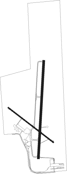
Runway info
Runway 1 / 19  | ||
| length | 1982m (6503ft) | |
| bearing | 11° / 191° | |
| width | 46m (150ft) | |
| surface | asphalt | |
| blast zone | 198m (650ft) / 0m (0ft) | |
| Runway 13 / 31 | ||
| length | 1160m (3806ft) | |
| bearing | 122° / 302° | |
| width | 23m (75ft) | |
| surface | asphalt | |
Nearby beacons
| code | identifier | dist | bearing | frequency |
|---|---|---|---|---|
| IMT | IRON MOUNTAIN VOR/DME | 0.1 | 134° | 111.20 |
| ES | PIKLE (ESCANABA) NDB | 37.7 | 96° | 344 |
| MNM | MENOMINEE VOR/DME | 43 | 144° | 109.60 |
| SAW | SAWYER VOR/DME | 44.1 | 53° | 117.10 |
| TN | TRIBE (MENOMINEE) NDB | 48.7 | 151° | 239 |
Instrument approach procedures
| runway | airway (heading) | route (dist, bearing) |
|---|---|---|
| RW01 | AFERO (40°) | AFERO 3900ft SEYOC (5mi, 95°) 3400ft |
| RW01 | OJOSO (339°) | OJOSO 3400ft SEYOC (5mi, 275°) 3400ft |
| RW01 | SEYOC (11°) | SEYOC 3400ft |
| RNAV | SEYOC 3400ft JUNEM (6mi, 11°) 2900ft LOOMS (3mi, 11°) 2000ft KIMT (3mi, 10°) 1185ft DAMPY (12mi, 11°) 3400ft DAMPY (turn) | |
| RW19 | BECKI (160°) | BECKI 3600ft DAMPY (5mi, 95°) 3400ft |
| RW19 | DAMPY (191°) | DAMPY 3400ft |
| RW19 | IRENE (220°) | IRENE 3400ft DAMPY (5mi, 275°) 3400ft |
| RNAV | DAMPY 3400ft HANDS (6mi, 191°) 3000ft KIMT (6mi, 191°) 1224ft SEYOC (12mi, 191°) 3400ft SEYOC (turn) |
Disclaimer
The information on this website is not for real aviation. Use this data with the X-Plane flight simulator only! Data taken with kind consent from X-Plane 12 source code and data files. Content is subject to change without notice.