Iowa City - Iowa City Muni
Airport details
| Country | United States of America |
| State | Iowa |
| Region | K3 |
| Airspace | Chicago Ctr |
| Municipality | Iowa City |
| Elevation | 666ft (203m) |
| Timezone | GMT -6 |
| Coordinates | 41.63978, -91.54814 |
| Magnetic var | |
| Type | land |
| Available since | X-Plane v10.40 |
| ICAO code | KIOW |
| IATA code | IOW |
| FAA code | IOW |
Communication
| Iowa City Muni ASOS | 128.075 |
| Iowa City Muni CTAF/UNICOM | 122.800 |
| Iowa City Muni CEDAR RAPIDS Approach/Departure | 119.700 |
Nearby Points of Interest:
Billingsley-Hills House
-Johnson County Courthouse
-Plum Grove Historic House
-Clark House
-College Block Building
-Franklin Printing House
-Paul–Helen Building
-Iowa City Downtown Historic District
-Pentacrest
-Kirkwood House
-Old Post Office
-Jefferson Street Historic District
-Union Brewery
-Linsay House
-Thomas C. Carson House
-Summit Apartment Building
-Nicking House
-St. Mary's Rectory
-Oakes-Wood House
-Emma J. Harvat and Mary E. Stach House
-Letovsky-Rohret House
-Parish Apartments
-Dr. Albert Henry Byfield House
-Czecho Slovakian Association Hall
-Ned Ashton House
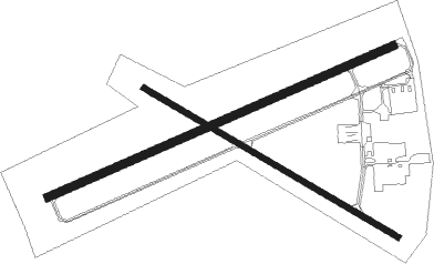
Runway info
Runway 7 / 25  | ||
| length | 1520m (4987ft) | |
| bearing | 75° / 255° | |
| width | 30m (100ft) | |
| surface | concrete | |
| displ threshold | 0m (0ft) / 244m (801ft) | |
| blast zone | 0m (0ft) / 46m (151ft) | |
| Runway 12 / 30 | ||
| length | 1187m (3894ft) | |
| bearing | 117° / 297° | |
| width | 23m (75ft) | |
| surface | concrete | |
Nearby beacons
| code | identifier | dist | bearing | frequency |
|---|---|---|---|---|
| IOW | IOWA CITY VOR/DME | 7.8 | 208° | 116.20 |
| CID | CEDAR RAPIDS VOR/DME | 18.2 | 316° | 114.10 |
| DDD | CITY DME | 24.3 | 124° | 116.50 |
| MZV | MOLINE VOR/DME | 45.1 | 109° | 114.40 |
| OTM | OTTUMWA VOR/DME | 50.7 | 232° | 111.60 |
| IIB | WAPSIE (INDEPENDENCE) NDB | 52 | 334° | 206 |
| DB | ZILOM (DUBUQUE) NDB | 58.9 | 54° | 341 |
| DBQ | DUBUQUE VORTAC | 59.1 | 48° | 115.80 |
| BRL | BURLINGTON VOR/DME | 61.8 | 146° | 111.40 |
| BR | BURNS (BURLINGTON) NDB | 62.2 | 157° | 390 |
| ALO | WATERLOO VOR/DME | 66.8 | 317° | 112.20 |
| BEX | BLOOMFIELD NDB | 66.9 | 225° | 269 |
Instrument approach procedures
| runway | airway (heading) | route (dist, bearing) |
|---|---|---|
| RW25 | BUCKA (255°) | BUCKA 3300ft |
| RNAV | BUCKA 3300ft HEWRI (4mi, 256°) 2800ft GRAFY (3mi, 255°) 2300ft ROLOC (3mi, 255°) 1480ft KIOW (3mi, 255°) 694ft (5475mi, 114°) 1100ft IOW (5478mi, 294°) 2600ft IOW (turn) | |
| RW30 | ICWAR (298°) | ICWAR 3000ft |
| RNAV | ICWAR 3000ft CURTT (6mi, 298°) 2400ft KIOW (6mi, 298°) 689ft (5475mi, 114°) 1100ft IOW (5478mi, 294°) 3000ft IOW (turn) |
Disclaimer
The information on this website is not for real aviation. Use this data with the X-Plane flight simulator only! Data taken with kind consent from X-Plane 12 source code and data files. Content is subject to change without notice.