Imperial - Imperial County
Airport details
| Country | United States of America |
| State | California |
| Region | K2 |
| Airspace | Los Angeles Ctr |
| Municipality | Imperial |
| Elevation | -54ft (-16m) |
| Timezone | GMT -8 |
| Coordinates | 32.83422, -115.57875 |
| Magnetic var | |
| Type | land |
| Available since | X-Plane v10.40 |
| ICAO code | KIPL |
| IATA code | IPL |
| FAA code | IPL |
Communication
| Imperial County ASOS | 132.175 |
| Imperial County UNICOM/CTAF | 122.700 |
Nearby Points of Interest:
El Centro Main Post Office
-Calexico Carnegie Library
-Algodones Dunes
-Desert View Tower
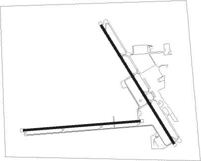
Runway info
Runway 14 / 32  | ||
| length | 1621m (5318ft) | |
| bearing | 149° / 329° | |
| width | 30m (100ft) | |
| surface | asphalt | |
| blast zone | 46m (151ft) / 46m (151ft) | |
| Runway 8 / 26 | ||
| length | 1369m (4491ft) | |
| bearing | 90° / 270° | |
| width | 23m (75ft) | |
| surface | asphalt | |
| blast zone | 46m (151ft) / 45m (148ft) | |
Nearby beacons
| code | identifier | dist | bearing | frequency |
|---|---|---|---|---|
| NJK | EL CENTRO TACAN | 5.1 | 269° | 111 |
| IPL | IMPERIAL VORTAC | 6.2 | 141° | 115.90 |
| MXL | MEXICALI VOR/DME | 21.1 | 121° | 115 |
| BZA | BARD (YUMA) VORTAC | 49.4 | 94° | 116.80 |
| NYL | YUMA TACAN | 50 | 101° | 113.70 |
| TRM | THERMAL VORTAC | 55.9 | 324° | 116.20 |
| BLH | BLYTHE VORTAC | 61.4 | 47° | 117.40 |
Disclaimer
The information on this website is not for real aviation. Use this data with the X-Plane flight simulator only! Data taken with kind consent from X-Plane 12 source code and data files. Content is subject to change without notice.