Orlando - Kissimmee Gateway
Airport details
| Country | United States of America |
| State | Florida |
| Region | K7 |
| Airspace | Miami Oceanic Ctr |
| Municipality | Kissimmee |
| Elevation | 82ft (25m) |
| Timezone | GMT -5 |
| Coordinates | 28.28981, -81.43708 |
| Magnetic var | |
| Type | land |
| Available since | X-Plane v10.40 |
| ICAO code | KISM |
| IATA code | ISM |
| FAA code | ISM |
Communication
| Kissimmee Gateway AWOS 3 | 128.775 |
| Kissimmee Gateway CTAF | 124.450 |
| Kissimmee Gateway UNICOM | 122.950 |
| Kissimmee Gateway ORLANDO Clearance DEL | 119.950 |
| Kissimmee Gateway Ground Control | 121.700 |
| Kissimmee Gateway Tower | 124.450 |
| Kissimmee Gateway ORLANDO Approach | 119.400 |
| Kissimmee Gateway ORLANDO Departure | 119.400 |
Approach frequencies
| ILS-cat-I | RW15 | 109.75 | 18.00mi |
| 3° GS | RW15 | 109.75 | 18.00mi |
Nearby Points of Interest:
Osceola County Courthouse
-Kissimmee Historic District
-First United Methodist Church
-Old Holy Redeemer Catholic Church
-Colonial Estate
-Grand Army of the Republic Memorial Hall
-Davenport Historic District
-1890 Windermere School
-Cal Palmer Memorial Building
-Windermere Town Hall
-St. Mark's Episcopal Church
-Downtown Haines City Commercial District
-J. J. Bridges House
-Old Central Grammar School
-Tinker Field
-Dr. P. Phillips House
-Orlando Utilities Commission Administration Building
-Well'sbuilt Hotel
-Holden-Parramore Historic District
-Palm Cottage Gardens
-Rogers Building
-Lake Eola Heights Historic District
-John N. Huttig Estate
-Lake Adair-Lake Concord Historic District
-Jack Kerouac House
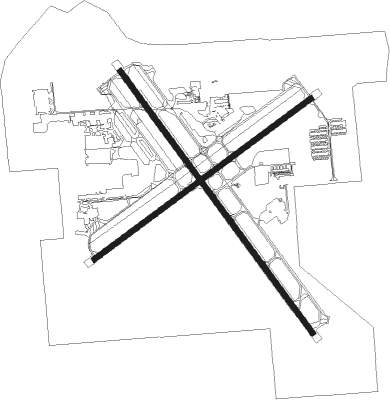
Runway info
Runway 15 / 33  | ||
| length | 1833m (6014ft) | |
| bearing | 145° / 325° | |
| width | 30m (100ft) | |
| surface | asphalt | |
| blast zone | 61m (200ft) / 61m (200ft) | |
| Runway 6 / 24 | ||
| length | 1524m (5000ft) | |
| bearing | 61° / 241° | |
| width | 30m (100ft) | |
| surface | asphalt | |
| blast zone | 62m (203ft) / 51m (167ft) | |
Nearby beacons
| code | identifier | dist | bearing | frequency |
|---|---|---|---|---|
| OR | HERNY (ORLANDO) NDB | 13 | 1° | 221 |
| ORL | ORLANDO VORTAC | 16.1 | 22° | 112.20 |
| LAL | LAKELAND VORTAC | 35.5 | 242° | 116 |
| COF | PATRICK (COCOA) TACAN | 43.7 | 94° | 115 |
| MLB | MELBOURNE VOR/DME | 43.8 | 103° | 115.85 |
| TRV | TREASURE (VERO BEACH) VORTAC | 62.2 | 123° | 117.30 |
| OCF | OCALA VORTAC | 67.5 | 318° | 113.70 |
Departure and arrival routes
| Transition altitude | 18000ft |
| Transition level | 18000ft |
| STAR starting points | distance | inbound heading | |
|---|---|---|---|
| ALL | |||
| JOKRS2 | 21.5 | 48° | |
| MINEE5 | 19.2 | 61° | |
| PRICY1 | 31.3 | 66° | |
| JAFAR2 | 52.7 | 139° | |
| SHREK2 | 49.3 | 146° | |
| LEESE3 | 38.6 | 149° | |
| GRNCH1 | 53.0 | 149° | |
| BITHO7 | 63.2 | 198° | |
| SNFLD1 | 49.6 | 202° | |
| ALYNA1 | 36.6 | 219° | |
| RIDES1 | 28.8 | 317° | |
| GOOFY7 | 26.6 | 317° | |
Instrument approach procedures
| runway | airway (heading) | route (dist, bearing) |
|---|---|---|
| RW06 | JENSN (99°) | JENSN ZOVLU (7mi, 139°) 2000ft FOJSO (5mi, 139°) 2000ft |
| RW06 | YOJIX (27°) | YOJIX VACTE (4mi, 318°) 2000ft FOJSO (5mi, 351°) 2000ft |
| RNAV | FOJSO 2000ft TOTNY (7mi, 61°) 1700ft EHECU (3mi, 61°) 760ft KISM (2mi, 62°) 125ft (4953mi, 109°) 600ft JENSN (4970mi, 289°) 4000ft JENSN (turn) | |
| RW15 | JENSN (99°) | JENSN WERPO (13mi, 69°) 2000ft |
| RW15 | ORL (202°) | ORL WERPO (13mi, 241°) 2000ft |
| RNAV | WERPO 2000ft WADSI (6mi, 145°) 1200ft KISM (4mi, 145°) 131ft YARTU (4mi, 145°) TEMPE (10mi, 220°) 2200ft TEMPE (turn) | |
| RW33 | PRESK (261°) | PRESK UFRAJ (12mi, 207°) 2000ft AXMEB (5mi, 250°) 2000ft |
| RW33 | YONMA (353°) | YONMA AXMEB (6mi, 55°) 2000ft |
| RNAV | AXMEB 2000ft LOJUF (6mi, 325°) 1700ft KISM (6mi, 325°) 121ft (4953mi, 109°) 540ft CAMBE (4962mi, 289°) 2000ft CAMBE (turn) |
Holding patterns
| STAR name | hold at | type | turn | heading* | altitude | leg | speed limit |
|---|---|---|---|---|---|---|---|
| ALYNA1 | GRDON | VHF | right | 19 (199)° | DME 10.0mi | ICAO rules | |
| ALYNA1 | SURFR | VHF | left | 79 (259)° | DME 10.0mi | ICAO rules | |
| ALYNA1 | TIMIE | VHF | left | 19 (199)° | DME 10.0mi | ICAO rules | |
| BITHO7 | LAMMA | VHF | left | 356 (176)° | < 17999ft | 1.0min timed | ICAO rules |
| BITHO7 | OMN | VHF | left | 2 (182)° | DME 10.0mi | ICAO rules | |
| GOOFY7 | BAIRN | VHF | right | 162 (342)° | < 17999ft | 1.0min timed | ICAO rules |
| GRNCH1 | ADLYN | VHF | left | 356 (176)° | DME 10.0mi | ICAO rules | |
| GRNCH1 | COAXE | VHF | left | 356 (176)° | DME 10.0mi | ICAO rules | |
| GRNCH1 | ELITE | VHF | left | 321 (141)° | DME 10.0mi | ICAO rules | |
| GRNCH1 | GRNCH | VHF | right | 337 (157)° | DME 10.0mi | ICAO rules | |
| JAFAR2 | BITTE | VHF | right | 304 (124)° | DME 10.0mi | ICAO rules | |
| JAFAR2 | BRKWL | VHF | left | 354 (174)° | DME 10.0mi | ICAO rules | |
| JAFAR2 | BUULL | VHF | right | 339 (159)° | DME 10.0mi | ICAO rules | |
| JAFAR2 | HUNKR | VHF | right | 339 (159)° | DME 10.0mi | ICAO rules | |
| JAFAR2 | ILEXX | VHF | right | 307 (127)° | DME 10.0mi | ICAO rules | |
| JAFAR2 | JAFAR | VHF | left | 343 (163)° | DME 10.0mi | ICAO rules | |
| JOKRS2 | FAZES | VHF | left | 169 (349)° | DME 10.0mi | ICAO rules | |
| JOKRS2 | MOANS | VHF | left | 183 (3)° | < 17999ft | 1.0min timed | ICAO rules |
| LEESE3 | LEESE | VHF | right | 309 (129)° | 1.0min timed | ICAO rules | |
| LEESE3 | SHIMM | VHF | right | 309 (129)° | 1.0min timed | ICAO rules | |
| MINEE5 | DOWNN | VHF | left | 183 (3)° | 1.0min timed | ICAO rules | |
| MINEE5 | MINEE | VHF | right | 240 (60)° | < 17999ft | 1.0min timed | ICAO rules |
| MINEE5 | MOANS | VHF | left | 183 (3)° | < 17999ft | 1.0min timed | ICAO rules |
| PRICY1 | CHIVE | VHF | right | 273 (93)° | DME 10.0mi | ICAO rules | |
| PRICY1 | DAAWG | VHF | right | 272 (92)° | DME 10.0mi | ICAO rules | |
| PRICY1 | DECKS | VHF | right | 276 (96)° | DME 10.0mi | ICAO rules | |
| PRICY1 | DOZES | VHF | right | 250 (70)° | DME 10.0mi | ICAO rules | |
| PRICY1 | PRICY | VHF | right | 252 (72)° | DME 10.0mi | ICAO rules | |
| RIDES1 | RIDES | VHF | left | 164 (344)° | DME 10.0mi | ICAO rules | |
| RIDES1 | ZALUP | VHF | right | 125 (305)° | DME 10.0mi | ICAO rules | |
| SHREK2 | BITTE | VHF | right | 304 (124)° | DME 10.0mi | ICAO rules | |
| SHREK2 | WANDD | VHF | right | 310 (130)° | DME 10.0mi | ICAO rules | |
| SNFLD1 | LPERD | VHF | right | 14 (194)° | DME 10.0mi | ICAO rules | |
| SNFLD1 | NOOMN | VHF | left | 2 (182)° | DME 10.0mi | ICAO rules | |
| *) magnetic outbound (inbound) holding course | |||||||
Disclaimer
The information on this website is not for real aviation. Use this data with the X-Plane flight simulator only! Data taken with kind consent from X-Plane 12 source code and data files. Content is subject to change without notice.