Wisconsin Rapids - Alexander Fld South Wood Co
Airport details
| Country | United States of America |
| State | Wisconsin |
| Region | K5 |
| Airspace | Minneapolis Ctr |
| Municipality | Town of Grand Rapids |
| Elevation | 1020ft (311m) |
| Timezone | GMT -6 |
| Coordinates | 44.36065, -89.83814 |
| Magnetic var | |
| Type | land |
| Available since | X-Plane v10.30 |
| ICAO code | KISW |
| IATA code | ISW |
| FAA code | ISW |
Communication
| Alexander Fld South Wood Co ASOS | 126.575 |
| Alexander Fld South Wood Co CTAF/UNICOM | 122.800 |
Nearby Points of Interest:
Old Plover Methodist Church
-Willard D. Purdy Junior High and Vocational School
-Adams County Courthouse
-L. A. Pomeroy House
-Pipe School
-Joseph Dessert Library
-Karl Mathie House
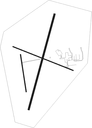
Runway info
Runway 2 / 20  | ||
| length | 1677m (5502ft) | |
| bearing | 27° / 207° | |
| width | 30m (100ft) | |
| surface | asphalt | |
| blast zone | 0m (0ft) / 30m (98ft) | |
| Runway 12 / 30 | ||
| length | 1108m (3635ft) | |
| bearing | 109° / 289° | |
| width | 15m (50ft) | |
| surface | asphalt | |
| displ threshold | 0m (0ft) / 52m (171ft) | |
| Runway 18 / 36 | ||
| length | 641m (2103ft) | |
| bearing | 174° / 354° | |
| width | 15m (50ft) | |
| surface | dirt | |
Nearby beacons
| code | identifier | dist | bearing | frequency |
|---|---|---|---|---|
| DAF | NECEDAH NDB | 22.2 | 217° | 233 |
| VOK | VOLK (CAMP DOUGLAS) TACAN | 30.9 | 225° | 110.40 |
| AUW | WAUSAU VOR/DME | 31.1 | 27° | 111.60 |
| CMY | MC COY NDB | 42.9 | 242° | 412 |
| DLL | DELLS (BARABOO) VORTAC | 48.7 | 175° | 117 |
Instrument approach procedures
| runway | airway (heading) | route (dist, bearing) |
|---|---|---|
| RW02 | HURST (41°) | HURST JENUN (20mi, 54°) 3000ft |
| RW02 | ZAVOX (350°) | ZAVOX JENUN (28mi, 340°) 3000ft |
| RNAV | JENUN 3000ft GIRLE (6mi, 4°) 2700ft KACHU (3mi, 23°) 1880ft XOBRY (2mi, 23°) 1229ft (5399mi, 116°) 1298ft UYOLU (5398mi, 296°) AKAKE (10mi, 28°) 3000ft AKAKE (turn) | |
| RW20 | AKAKE (207°) | AKAKE 3000ft |
| RW20 | RROBB (239°) | RROBB AKAKE (9mi, 270°) 3000ft |
| RNAV | AKAKE 3000ft MERVE (7mi, 207°) 2700ft UHTIZ (3mi, 207°) 1640ft KISW (2mi, 207°) 1063ft (5398mi, 116°) 1380ft WEMUG (5400mi, 296°) OCEDE (5mi, 109°) LHALL (5mi, 57°) FAYYE (5mi, 5°) 3000ft FAYYE (turn) |
Disclaimer
The information on this website is not for real aviation. Use this data with the X-Plane flight simulator only! Data taken with kind consent from X-Plane 12 source code and data files. Content is subject to change without notice.